Skip Links

USGS - science for a changing world

Data Series 995

Cupsoque Inset Map


Home | Abbreviations | Contents | Photographs and Maps | Navigation Data | Logs | Metadata | Citation Page


Click on a segment name to view the contact sheet.

Cupsoque inset map ds995_2015_1008_161500 ds995_2015_1008_162000 ds995_2015_1008_162500 ds995_2015_1008_163000
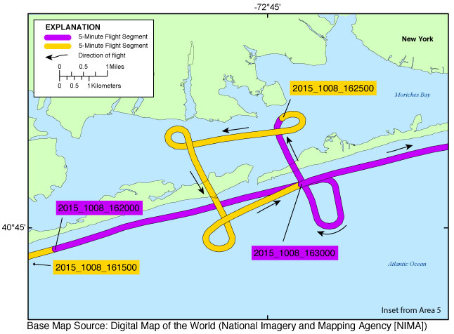
Figure 8. Cupsoque inset map (Area 5). Map showing the flight path of the post-Hurricane Joaquin coastal oblique aerial survey of from West Hampton Dunes, New York, to Smith Point County Park, New York, on October 8, 2015. Purple and yellow lines correspond to 5-minute flight segments that link to contact sheets of associated photograph thumbnails. Click on the 5-minute segment name to view each contact sheet.


Full Survey Area | 2015-338-FA: Area 1 | 2015-338-FA: Area 2 | 2015-338-FA: Area 3 | 2015-338-FA: Area 4 | 2015-338-FA: Area 5
2015-338-FA: Area 6 | 2015-338-FA: Area 7 | 2015-338-FA: Area 8

Ocean City, Maryland, Inset Map | Mantoloking Inset Map | Mid-Fire Island Inset Map | Old Inlet Inset Map | Cupsoque Inset Map
Shinnecock Inset Map | Cape Fear Inset Map | Cape Lookout Inset Map | Hatteras Inset Map | Cape Hatteras Inset Map
Rodanthe Inset Map | Pea Island Inset Map

Home | Abbreviations | Contents | Photographs and Maps | Navigation Data | Logs | Metadata | Citation Page

Accessibility FOIA Privacy Policies and Notices

Take Pride in America logo USA.gov logo U.S. Department of the Interior | U.S. Geological Survey
URL: http://pubsdata.usgs.gov/pubs/ds/0995/html/ds995_inset08_cupsoque.html
Page Contact Information: GS Pubs Web Contact
Page Last Modified: Monday, 28-Nov-2016 20:48:05 EST