


Error Analysis
|
Like all survey data, the position of a bathymetric sounding has three components, X, Y and Z, where X and Y are the horizontal position and Z is the vertical position. Differential GPS was used to compute all X,Y,Z positions presented in this report. Due to the geometric solutions used to solve an X,Y,Z position from GPS data, it can be assumed that the accuracy of the X,Y position is typically twice as good as the Z position and the errors associated with the X,Y position are about half of the Z position. Thus, the reported X,Y accuracies and errors presented in this report are based on this assumption, that is, not actually computed. The vertical component, Z, also known as the elevation of the sea floor, or approximate water depth, is the most critical component of the three components (X,Y,Z) and is the focus of the survey error analysis. The horizontal and vertical accuracies of GPS position measurements are dependent on many factors such as: GPS satellite geometry strength or Position Dilution of Precision (PDOP), distance from the reference receiver, and ionospheric, tropospheric, and local atmospheric conditions. Under ideal conditions, all of these factors can be controlled; however, survey costs and time constraints necessitate some flexibility from ideal conditions. Hydrographic surveys employ multiple sensors to accurately determine sea floor elevations, and GPS measurements have the greatest influence on survey accuracies. Survey vertical bias errors are those associated with the GPS reference station and supply a constant offset to the sounding data. These types of errors are considered absolute, because the reference station coordinates are relative to the earth. Vertical bias errors are reported by the static GPS processing software programs that were used to compute the reference station coordinates. The majority of the surveys in this report used three online GPS processing software programs: GNSS-Inferred Positioning System and Orbit Analysis Simulation Software (GIPSY), Scripps Coordinate Update Tool (SCOUT), and On-Line Processing User Service (OPUS). Later surveys used only OPUS because of software improvements. Because of the complexity and uncertainty of evaluating combined vertical errors associated with the sounder/lidar laser, motion sensor, and GPS trajectories, a proven and effective solution is to assess sea floor elevation differences at trackline crossings. Figure 7 illustrates two tracklines that intersect and the elevation difference at the intersection. In theory, the values at a crossing point should be the same and any deviation represents combined errors. The Root Mean Squared (RMS) of all the crossing differences (dZ) is a good indication of survey vertical accuracy (assuming no change in sea floor depth). This technique evaluates the relative accuracy of the survey, because all measurements are relative to the reference station coordinates. Total sounding vertical errors presented in this report are a combination of the survey bias and the trackline crossing difference RMS. The estimated horizontal and vertical accuracies are listed in the Survey Highlights section on each project's Description page. |
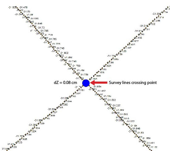 Fig. 7. Example of sounding crossing point error. |
Disclaimer: This report was prepared by an agency of the United States Government. Although these data have been processed successfully on a computer system at the U.S. Geological Survey (USGS), no warranty expressed or implied is made regarding the display or utility of the data on any other system, nor shall the act of distribution imply any such warranty. The USGS shall not be held liable for improper or incorrect use of the data described and (or) contained herein. Reference herein to any specific commercial product, process, or service by trade name, trademark, manufacturer, or otherwise does not constitute or imply its endorsement, recommendation, or favoring by the United States Government or any agency thereof. |
