Project Description - Lemon Bay (2011)
|
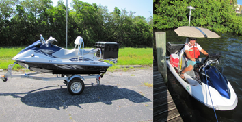
Figure 43. Project study area - Lemon Bay, Florida. [Click on icon for link to data page] Lemon Bay is a long, narrow body of water on the west-central Florida coast, straddling both Sarasota and Charlotte Counties (fig. 43). The bay encompasses nearly 32 square kilometers (km2) and ranges in depth from 7 meters (m) at Stump Pass to less than 0.1 m on the many emergent shoals throughout the bay. The bay is home to a sizeable manatee population where they feed on seagrass in the very shallow waters. Manatees have been tracked by satellite, and it has been found that their daily routine includes moving to and from grass flats including crossing the Intercoastal Water Way (ICWW). Unfortunately, due to the configuration of the main ICWW, there are high incidents of manatee deaths due to boat collisions (Deutsch and Reynolds, 2012). In an effort to reduce fatalities, the Florida Fish and Wildlife Conservation Commission (FWC) and the Wildlife Foundation of Florida have developed a program entitled "Manatee Response to Boats." The U.S. Geological Survey (USGS), in collaboration with FWC, developed a strategy to map the sea floor of Lemon Bay. As stated in the collaborative agreement: “The overarching goal of the study is to understand how manatees respond to watercraft in their natural environment in order to provide managers with a solid scientific basis for taking actions to reduce the risk of vessel strikes. The specific goal of this FWC funded project is to create a detailed bathymetric map of the study area using a vessel-mounted acoustic system. Data on bathymetry provide the essential physiographic context for understanding manatee-boat interactions and constraints on manatee movements and habitat use.” To fulfill plan objectives, the USGS was tasked with performing a high precision bathymetric survey in all areas of the bay “reachable by boat” (fig. 44). The operation included the use of three different single-beam bathymetry mapping platforms: a 21-foot (ft) shallow-draft boat for deeper sections, a 16-ft flat-back canoe, and a jet-ski to collect data in the shallow portions of the bay.
Figure 44. Photo of shallow water jet ski survey platform and operator on jet ski. |
SURVEY HIGHLIGHTS
|