


Establishing New Control using GIPSY, SCOUT and OPUS
|
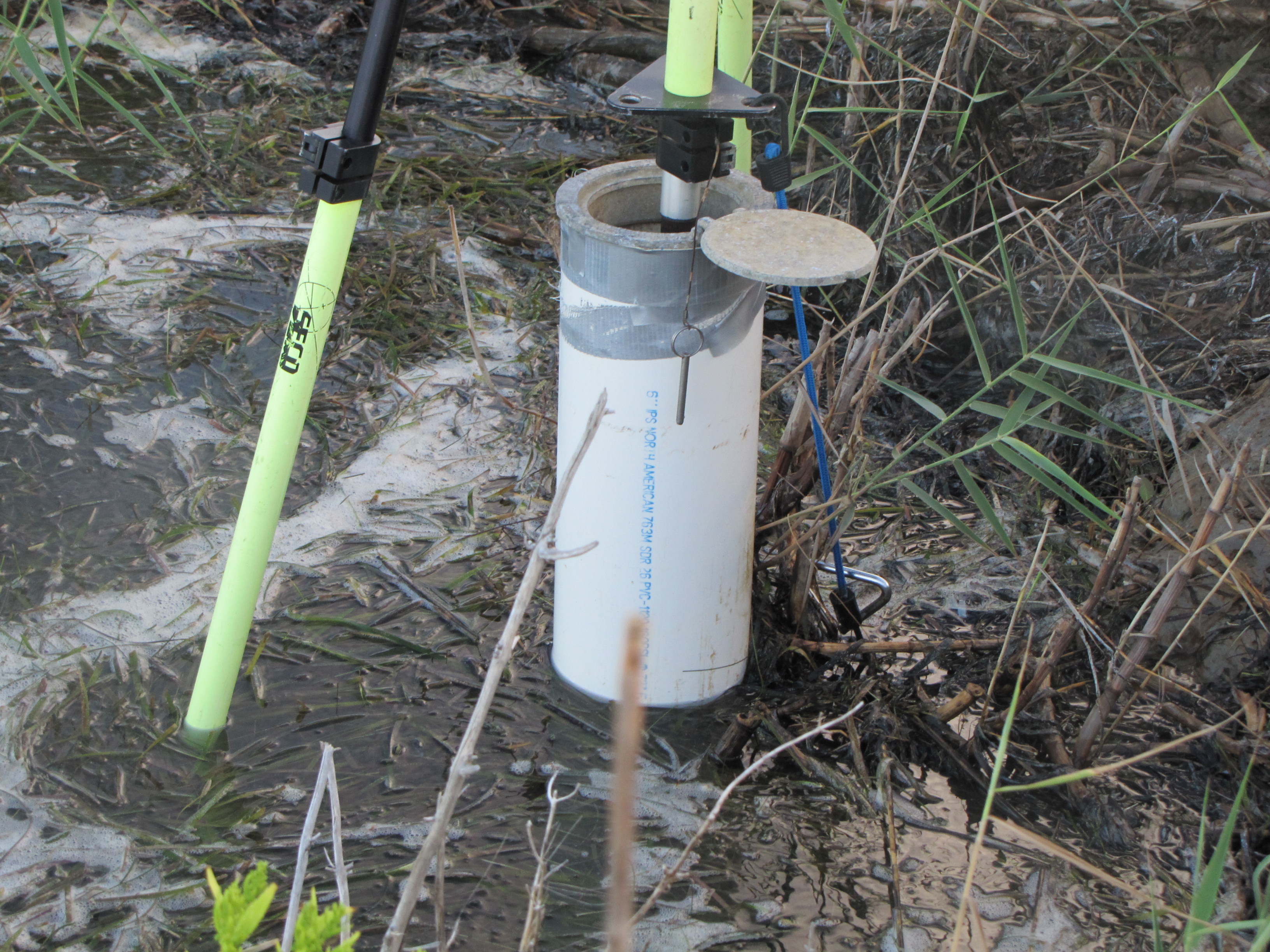
The preferred method for obtaining GPS reference station coordinates is to occupy first-order (Class I) vertical and first-order horizontal monuments (bench marks) established by the National Geodetic Survey (NGS). However, it is seldom that first-order monuments are near the study site and convenient to access by either land or boat. In addition, locating appropriate monuments without obstructions is often problematic. To overcome the issue of locating high order bench marks, scientists at the USGS have developed a method for establishing new bench marks. It should be noted that this method does not conform to NGS "Blue Book" standards, but internal tests conducted by the USGS indicate this method is accurate to +/- 2 centimeters (cm). Novatel Waypoint Consulting, Inc., a GPS software development company, compared data using this method to traditional GPS methods and found similar results (McDonald, 2002). When the USGS establishes a new bench mark, the location is carefully selected to avoid multipath errors. Signal multipathing errors occur when a GPS signal reflects off a nearby structure and is recorded along with the original unobstructed signal. Thus, two identical signals are recorded, each with different arrival times, thereby corrupting the signal. The general guideline applied is that the GPS antenna must be located where there are no signal obstructions above 10 degrees from the horizon and easily assessible. Industry standard survey components were used for physically building a new bench mark (fig. 13). When the location is over soil, the components consist of sectional 1meterlong by 1.905cmdiameter aluminum pipe, survey cap, 7.6-cm PVC, and bag concrete. The sections of aluminum pipe are coupled together and driven to refusal; the upper 0.3- to 0.6-m section is excavated and encased with the 7.6-cm polyvinyl chloride (PVC) pipe. The cavity is filled with concrete, and the survey cap is attached. If the location is situated on tarmac pavement or a road surface, a hardened 3-inch Parker Kalon (PK) survey nail is driven into the surface. The new bench mark is occupied by the reference GPS receiver for a minimum of three 8-hour occupations recorded at 30-second epoch intervals. Three independent GPS autonomous processing software services are then used to derive the position of the new bench mark, for each daily occupation. The services provided are National Aeronautics and Space Administration's (NASA) Jet Propulsion Laboratory's (JPL) GIPSY, NGS OPUS, and Scripts Institute SCOUT software. GIPSY software computes base station coordinates by accurately modeling (submeter) the orbital trajectories of the NAVSTAR GPS satellites and is capable of computing base station coordinates to less than 1 cm root mean square (RMS). OPUS and Scout software use the average of three distinct single-baseline solutions computed by double-differenced, carrier-phase measurements from three different reference sites. OPUS uses the nearest three Continuously Operating Reference Stations (CORS) and SCOUT uses the nearest three International GPS Service (IGS) stations. The stated vertical accuracies of OPUS and SCOUT are between 1 and 3 cm RMS. GIPSY coordinates are provided in International Terrestrial Reference Frame 2000 (ITRF00) and converted to World Geodetic System 1984 (WGS84) horizontal coordinates and ellipsoid height vertical coordinates using NGS Horizontal Time-Dependent Positioning (HTDP) software. OPUS and SCOUT coordinates are provided in NAD83 horizontal coordinates and converted to WGS84 horizontal coordinates and ellipsoid height vertical coordinates using NGS HTDP software. Positions derived from all occupations and all processing software services were then averaged. The derived position was applied when processing the kinematic boat trajectory data. |

