Project Description - Southwest Florida Rivers (2015)
|
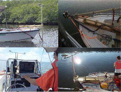
Figure 47. Project study area - Lower Shark and Lostmans Rivers. [Click on icon for link to data page] During the past century, river and tidal creeks through the coastal wetlands of the Everglades have filled with sediment and vegetation of surrounding landscapes to the point that many have greatly diminished or disappeared entirely. Restoration plans are under consideration to redirect additional freshwater inflow from the Everglades to open and sustain these waterways to a level that closely resembles historical patterns. In the last 100 years, requirements for water supply and flood protection for urban areas and agriculture in south Florida have resulted in the construction of an extensive canal system to prompt drainage of water into the Atlantic Ocean rather than allowing historic seasonal seepage through the Everglades and Florida Bay. Water diversions and excessive nutrients and contaminants within the Everglades have decimated bird populations and driven the Florida panther to the brink of extinction (Roelke and Glass, 1992). Modern and comprehensive bathymetric data were needed for South Florida Water Management District (SFWMD) hydrodynamic modeling in order to determine minimum flow levels (MFL). U.S. Geological Survey (USGS) Priority Ecosystem Science studies also require these data to improve society's understanding of the environment and assist in the sustainable use, protection, and restoration of the Everglades and other ecosystems within the southwest region of Florida. A shallow-water, sonar swath interferometric system was selected as best suited for fulfilling multiple project requirements. Recent analyses of geodatabases from the Southwest Florida Rivers (2004) project show that Lostmans River and several segments of Lower Shark River had not been mapped (fig. 47). Surveys for these areas provided an invaluable and completed set of bathymetric surveys of coastal rivers along the southwest coast of Everglades National Park (ENP). The USGS, in cooperation with ENP, performed a bathymetric survey of the Lostmans and Lower Shark Rivers area using a swath interferometric hydrographic system (fig. 48).
Figure 48. Interferometric swath system setup on the USGS shallow-draft survey boat, R/V Mako. |
SURVEY HIGHLIGHTS
|