Data Series 1033
|
Introduction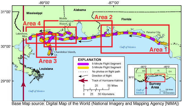 Figure 1. Map showing the post-Hurricane Katrina coastal oblique survey flight path from Panama City, Florida, to Lakeshore, Mississippi, and the Chandeleur Islands, Louisiana, August 31, 2005. Click in an area box (1–4) to view a detailed map. The U.S. Geological Survey (USGS), as part of the National Assessment of Storm-Induced Coastal Change Hazards project, conducts baseline and storm-response photography missions to document and understand the changes in vulnerability of the Nation's coasts in response to extreme storms. On August 31, 2005, the USGS conducted an oblique aerial photography survey from Panama City, Florida, to Lakeshore, Mississippi, and the Chandeleur Islands, Louisiana (fig. 1), aboard a Piper Navajo Chieftain aircraft at an altitude of 500 feet (ft) and approximately 1,000 ft offshore (fig. 2). This mission was flown to collect post-Hurricane Katrina data, which can be used to assess incremental changes in the beach and nearshore area since the previous survey, flown in July 2001 (unpublished data). The data can be used to assess future coastal change and recovery. The photographs in this report are Joint Photographic Experts Group (JPEG) images. The software ExifTool was used to add the following to the header of each photograph: time of collection, Global Positioning System (GPS) latitude, GPS longitude, keywords, credit, artist (photographer), caption, copyright, and contact information. The photograph locations are an estimate of the position of the aircraft at the time each photograph was taken and do not indicate the location of any feature shown in the images (see the Navigation Data page). These photographs document the state of the barrier islands and other coastal features at the time of the survey. Pages containing thumbnail images of the photographs, referred to as contact sheets, were created in 5-minute segments of flight time. These segments are shown in figures 3A–3D on the Photographs and Maps page. Photographs can be opened directly with any JPEG-compatible image viewer by clicking on a thumbnail on the contact sheet. In addition to the photographs, a Google Earth Keyhole Markup Language (KML) file is provided and can be used to view the images by clicking on the marker and then clicking on either the thumbnail or the link above the thumbnail. The KML file was created using the photographic navigation files and can be found in the kml folder. Links to the full-sized images can be found on the Photographs and Maps page and in table 1. KML files, Hypertext Markup Language (HTML) files, images used to produce the Web pages, and a readme file are also included in this report. GPS data collected during the flight are available on the Navigation Data page. The Logs page contains information about the flight and the equipment used. List of FiguresFigure 2. Diagram of the survey flight acquisition geometry Figure 3A. Area 1—Panama City, Florida, to Pensacola Beach, Florida Figure 3B. Area 2—Pensacola Beach, Florida, to Ship Island, Mississippi Figure 3C. Area 3—Cat Island, Mississippi, to the Chandeleur Islands, Louisiana Figure 3D. Area 4—Coden, Alabama, to Lakeshore, Mississippi Figure 4. Navarre, Florida, inset map (Area 1) |

![]() U.S. Department of the Interior |
U.S. Geological Survey
U.S. Department of the Interior |
U.S. Geological Survey
URL: http://pubsdata.usgs.gov/pubs/ds/1033/html/ds1033_introduction.html
Page Contact Information: GS Pubs Web Contact
Page Last Modified: Wednesday, 29-Mar-2017 10:53:27 EDT
