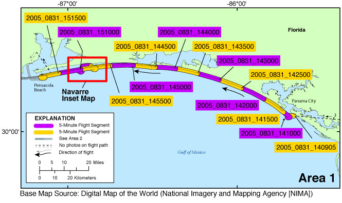
USGS - science for a changing world

Data Series 1033

Post-Hurricane Katrina Coastal Oblique Aerial Photographs Collected From Panama City, Florida, to Lakeshore, Mississippi, and the Chandeleur Islands, Louisiana, August 31, 2005

Skip Links

Citation Page
Abstract
Introduction
Photographs and Maps
Navigation Data
Logs
Metadata
Abbreviations
 

Photographs and Maps

The maps below show the division of the survey into Areas 1–4 (figs. 3A–3D) and the flight path in each area divided into 5-minute (time) segments. Alternating purple and yellow lines represent each segment. Pages containing thumbnail images of the photographs, referred to as contact sheets, were created based on these 5-minute segments. Click on each segment name to access the associated contact sheet.

Segment names are labeled with the following file name convention: yyyy_mmdd_hhmmss, where yyyy denotes the year, mmdd denotes the month and day, and hhmmss denotes the start time in hours, minutes, and seconds of the 5-minute segment of time during which those photographs were taken. All times refer to Coordinated Universal Time (UTC). For example, segment 2005_0831_164000 was taken August 31, 2005, starting at 16:40:00 UTC. An effort was made to set the camera's internal clock to within 1 second of UTC at the beginning of the flight.

Table of Images

Table 1 provides detailed information about the image name, GPS location, date, and time for each of the 3,738 photographs taken during this survey, along with links to each photograph and contact sheet.

KML file

A Keyhole Markup Language (KML) file, ds1033_05CCH02.kml, can be found in the kml folder with a readme file describing the KML. This file can be used to view the images in Google Earth by clicking on the image marker and then the thumbnail or the link above the thumbnail.


05CCH02: Area 1—Panama City, Florida, to Pensacola Beach, Florida

05CCH02: Area 1 Map ds1033_2005_0831_141500 ds1033_2005_0831_142000 ds1033_2005_0831_145500 Navarre Inset Map ds1033_2005_0831_140905 ds1033_2005_0831_144000 ds1033_2005_0831_144500 ds1033_2005_0831_145000 ds1033_2005_0831_142500 ds1033_2005_0831_143000 ds1033_2005_0831_143500 ds1033_2005_0831_141000 ds1033_2005_0831_151000 ds1033_2005_0831_151500

Figure 3A. Area 1—Panama City, Florida, to Pensacola Beach, Florida. Map showing the post-Hurricane Katrina flight path divided into 5-minute (time) segments. The flight path is represented by the alternating purple and yellow lines. Pages containing thumbnail images of the photographs, referred to as contact sheets, were created based on these segments. Click on the 5-minute segment name to view each contact sheet. Click on the inset box to view a detailed map of the area.

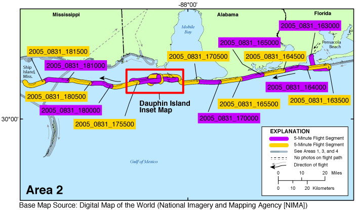
05CCH02: Area 2—Pensacola Beach, Florida, to Ship Island, Mississippi

05CCH02: Area 2 Map Dauphin Island Inset Map ds1033_2005_0831_163000 ds1033_2005_0831_163500 ds1033_2005_0831_164000 ds1033_2005_0831_164500 ds1033_2005_0831_165000 ds1033_2005_0831_165500 ds1033_2005_0831_170000 ds1033_2005_0831_170500 ds1033_2005_0831_175500 ds1033_2005_0831_180000 ds1033_2005_0831_180500 ds1033_2005_0831_181000 ds1033_2005_0831_181500

Figure 3B. Area 2—Pensacola Beach, Florida, to Ship Island, Mississippi. Map showing the post-Hurricane Katrina flight path divided into 5-minute (time) segments. The flight path is represented by the alternating purple and yellow lines. Pages containing thumbnail images of the photographs, referred to as contact sheets, were created based on these segments. Click on the 5-minute segment name to view each contact sheet. Click on the inset box to view a detailed map of the area.

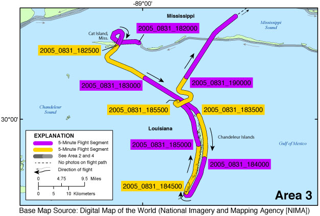
05CCH02: Area 3—Cat Island, Mississippi, to the Chandeleur Islands, Louisiana

05CCH02: Area 3 Map ds1033_2005_0831_182000 ds1033_2005_0831_182500 ds1033_2005_0831_183000 ds1033_2005_0831_183500 ds1033_2005_0831_184000 ds1033_2005_0831_184500 ds1033_2005_0831_185000 ds1033_2005_0831_185500 ds1033_2005_0831_190000

Figure 3C. Area 3—Cat Island, Mississippi, to the Chandeleur Islands, Louisiana. Map showing the post-Hurricane Katrina flight path divided into 5-minute (time) segments. The flight path is represented by the alternating purple and yellow lines. Pages containing thumbnail images of the photographs, referred to as contact sheets, were created based on these segments. Click on the 5-minute segment name to view each contact sheet.

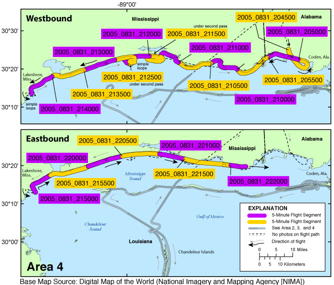
05CCH02: Area 4—Coden, Alabama, to Lakeshore, Mississippi

05CCH02: Area 4 Map ds1033_2005_0831_204500 ds1033_2005_0831_205000 ds1033_2005_0831_205500 ds1033_2005_0831_210000 ds1033_2005_0831_210500 ds1033_2005_0831_211000 ds1033_2005_0831_211500 ds1033_2005_0831_212000 ds1033_2005_0831_212500 ds1033_2005_0831_213000 ds1033_2005_0831_213500 ds1033_2005_0831_214000 ds1033_2005_0831_215000 ds1033_2005_0831_215500 ds1033_2005_0831_220000 ds1033_2005_0831_220500 ds1033_2005_0831_221000 ds1033_2005_0831_221500 ds1033_2005_0831_222000

Figure 3D. Area 4—Coden, Alabama, to Lakeshore, Mississippi. Map showing the post-Hurricane Katrina flight path divided into 5-minute (time) segments. The flight path is represented by the alternating purple and yellow lines. Pages containing thumbnail images of the photographs, referred to as contact sheets, were created based on these segments. Click on the 5-minute segment name to view each contact sheet.


Navarre Inset Map | Dauphin Island Inset Map

Accessibility FOIA Privacy Policies and Notices

Take Pride in America logo USA.gov logo U.S. Department of the Interior | U.S. Geological Survey
URL: http://pubsdata.usgs.gov/pubs/ds/1033/html/ds1033_photos.html
Page Contact Information: GS Pubs Web Contact
Page Last Modified: Wednesday, 29-Mar-2017 10:55:50 EDT