Data Series 1100
| Field Data CollectionUSGS scientists collected 14 vibracores on April 10 and 11, 2016 (USGS FAN 2016–322–FA), along 6 transects that extend from the upper to the lower subaerial shoreface at Fire Island. Henderson and others (2015, 2017; see U.S. Geological Survey, undated) collected repeat cross-shore beach elevation profiles before and after Hurricane Sandy (including at the same time the vibracores were collected) to document storm-induced coastal change and subsequent beach response and recovery. Core locations were selected where profile data analyses indicated that the recovery of sediments from below the post-Hurricane Sandy surface was possible. The coring transects correspond to the locations of beach elevation profiles 10, 11 (western Fire Island geomorphic zone), 22 (central geomorphic zone), and 25, 26, and 29 (eastern geomorphic zone) (fig. 3). 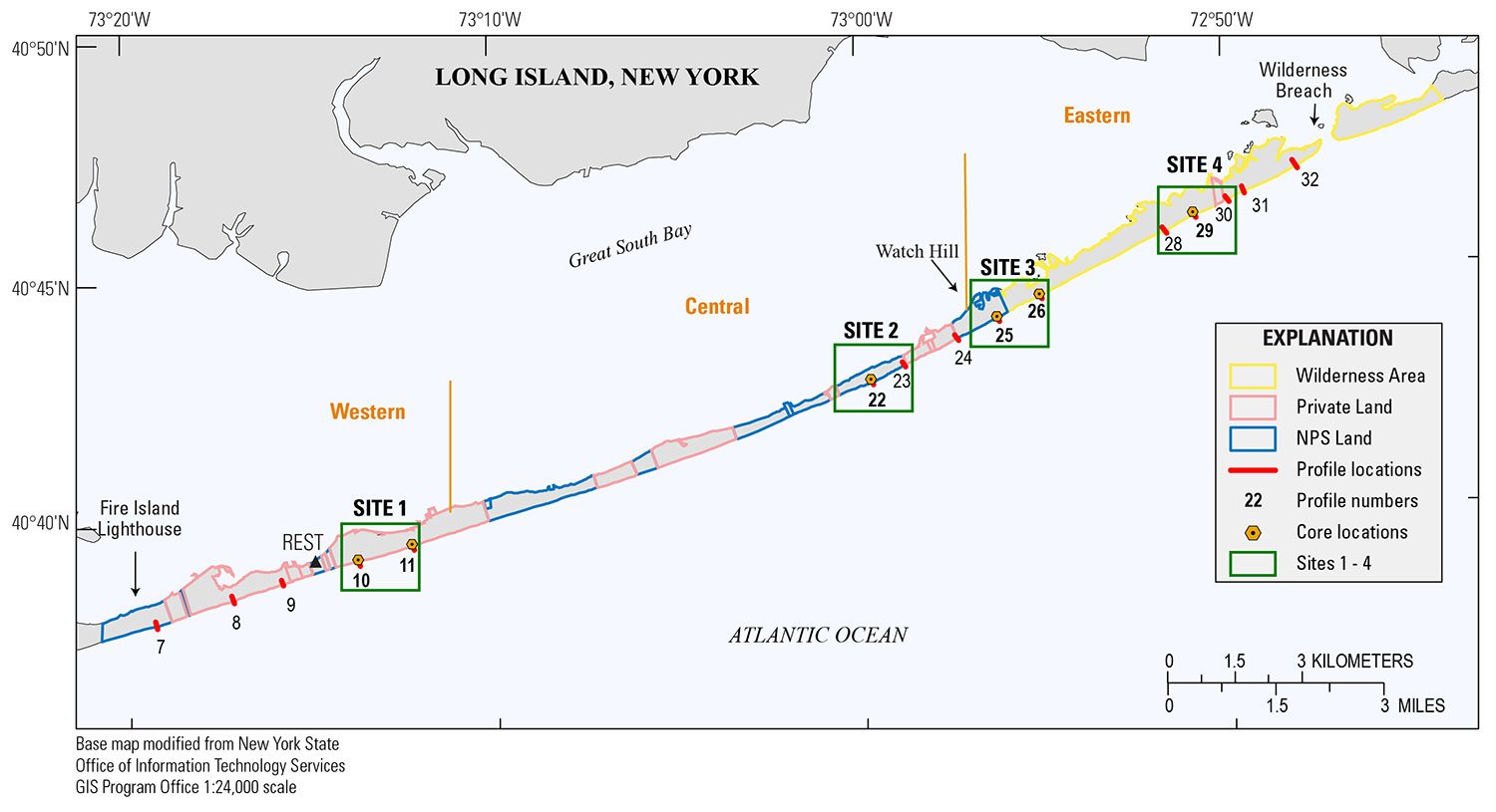 Figure 3. Locations of sites where vibracores were collected along previously surveyed beach-elevation profiles in April 2016 (USGS FAN 2016-322–FA) and the differential global positioning system (DGPS) base station at Robbins Rest (REST) on Fire Island, New York. [NPS, National Park Service] [Click figure to enlarge] All vibracore locations were recorded at the time of collection by using a Garmin GPSMAP 76S handheld Global Positioning System (GPS) receiver. Position and elevation data were also recorded with an Ashtech DGPS receiver and geodetic antenna, which provided more accurate horizontal and vertical control than the handheld GPS. A stop-and-go rapid-static survey technique was used, with a static occupation duration of 5 minutes at each sample location. The DGPS data were recorded concurrently throughout the survey using a similar instrument combination (Ashtech receiver and Thales choke ring antenna) at a base station set up on the National Park Service (NPS) Robins Rest (REST) benchmark (fig. 3). Vibracores were collected using an 8-horsepower Briggs and Stratton motor connected by way of an 8.5-m-long (27.9-foot-long) shaft to a Dreyer 5.4-centimeter (cm) (2 1/8-inch) concrete vibrator head (fig. 4). The vibrator was attached to a 7.6-cm- (3-inch-) diameter aluminum core barrel using a quick-release clamp, and the core barrel was vibrated into the subsurface until refusal. Measurements were taken on the inside and outside of the core barrel prior to extraction to determine compaction or core shortening values (Morton and White, 1997) calculated as the difference between the recovered core length and the total depth the core barrel penetrated below the sediment surface. After extraction, each core was capped, sealed, and labeled with the core number and orientation. All cores were transported to the St. Petersburg Coastal and Marine Science Center (SPCMSC) sediment laboratory for processing and analysis. 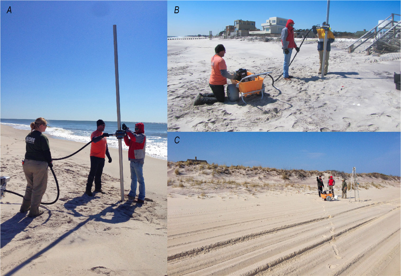 Figure 4. Vibracores being collected at core locations (A) P11-C01, (B) P10-C03, and (C) P22-C13 on Fire Island, New York. Photographs by Jennifer Miselis and Kyle Kelso (U.S. Geological Survey). [Click figure to enlarge] |

![]() U.S. Department of the Interior |
U.S. Geological Survey
U.S. Department of the Interior |
U.S. Geological Survey
URL: http://pubsdata.usgs.gov/pubs/ds/1100/ds1100_data-collection.html
Page Contact Information: GS Pubs Web Contact
Page Last Modified: Thursday, 15-Nov-2018 11:45:35 EST
