 |
|
|
||||
| U.S. Geological Survey Data Series 344 |
|
Photographs from each vibracore were taken to visually represent the general physical properties of the core. These include but are not limited to sediment texture characteristics, color, composition, bedding structures, and biogenic content as seen on the Vibracore Description Sheets page.
Photographs are available for the following cruises: CR83, P86, 00SCC.
Accessing the Data To access the data for each core simply click on the Study Area Map (right) and then navigate to the section that contains the desired core. Right-click (to open page in a new window) on a core or core label to activate a table that contains links to specific data sets for each core. All vibracore photographs for each cruise are presented in the data table on the Core Data Table page. The table contains a column entitled vibracore photographs that contains each cores thumbnail preview and links to JPEG files. |
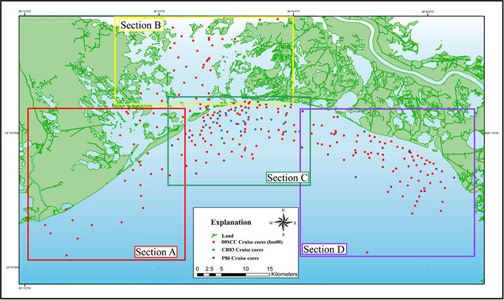
Click on the Study Area Map above to open an enlarged map version. The enlarged map contains core locations that are linked to Vibracore Description Sheets, Interpreted Core Classification Profiles, Photographs, and Grain-Size and Penetrometer Data. |


![]() U.S. Department of the Interior |
U.S. Geological Survey
U.S. Department of the Interior |
U.S. Geological Survey
URL: https://pubsdata.usgs.gov/pubs/ds/344/html/Photos.html
Page Contact Information: Publications Team
Page Last Modified: Monday, 28-Nov-2016 13:00:56 EST