 |
|
|
||||
| U.S. Geological Survey Data Series 344 |
|
Information defining the borehole description sheets and explaining how the data were obtained and processed is available in the Methods section under Sediment- Borehole Collection (for USACE cores only). This section contains information about the borehole description sheets and the grain-size data. For this cruise a paper copy of each borehole description sheet was scanned and converted into a downloadable PDF document (image only). The format of the description sheet is based upon the output of the USACE BORPLOT program. However, all description sheets contain similar information such as the core ID (B-#), date, and location. The following figures depict the USACE type of description sheets and the sediment type legend used for this type of description sheet. This sediment type legend appears at the bottom of the page on each description sheet. This section also contains information about the downloadable borehole grain-size data. The downloadable Microsoft Excel spreadsheet (XLS) files contain a grain-size table with data on each of the sub-samples that were taken down core, listed under the Sample ID. For greater detail on the table attribute columns on the spreadsheets, please refer to the Grain-Size and Penetrometer Data page.
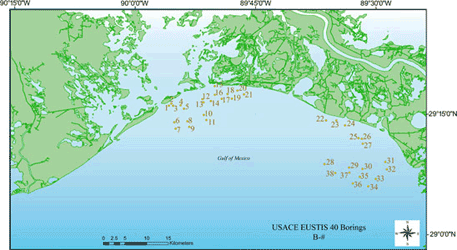
Accessing the Data To access the data for each core simply click on the USACE EUSTIS study area map (right) to skip to the enlarged map version (below). Right-click (to open page in a new window) on a core or core label to activate a table that contains links to specific data sets for each core. The borehole description sheet and grain-size data for each cruise are presented in the data table on the Core Data Table page. The table contains two columns that pertain to the USACE EUSTIS cores, one with Core Description Sheet previews and downloadable PDF files and the other with Grain-Size Analysis Data previews and downloadable XLS files. |

Click on the USACE EUSTIS study area map above to skip to the enlarged map version (below). The enlarged map shows the location of the borehole cores in more detail. To view the 00SCC, CR83 and P86 vibracores, please refer to the Study Area Map. |


