
Multibeam Sonar Mapping and Modeling of a Submerged Bryophyte Mat in Crater Lake, Oregon
Selected Views and Movies
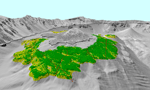 |
View 1. Perspective view looking north toward Wizard Island (center) showing the distribution of the bryophyte mat (moss) over Wizard Island platform
Green shades show thicker, continuous mats of moss, whereas yellow shades show areas with thinner, patchy coverage. The red dots show points where moss was observed during the August 2006 camera sled ground-truthing cruise. The vertical exaggeration in this image is 2X. Large Image (152 Kb) View Full-Size Image (568 Kb) |
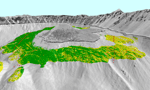 |
View 2. Perspective view looking south toward Wizard Island (center) showing the distribution of the bryophyte mat (moss) over Wizard Island platform
Green shades show thicker, continuous mats of moss, whereas yellow shades show areas with thinner, patchy coverage. The red dots show points where moss was observed during the August 2006 camera sled ground-truthing cruise. The vertical exaggeration in this image is 2X. Large Image (164 Kb) View Full-Size Image (640 Kb) |
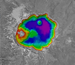 |
Movie 1. Fly-though movie around Crater Lake, Oregon
The color-coded lake floor was generated from the 2000 multibeam bathymetry data. Reds and oranges are shallower whereas dark blues and purples are deeper. The grey-scale land area is generated by draping digital orthophotographs (DOQs) over U.S. Geological Survey 10-m digital elevation models (DEMs). The movie starts by looking straight down over the lake and then zooms toward Wizard Island. It then flies between the western side of the island and the caldera wall and turns east flying along the northern side of the lake toward Merriam Cone. Flying around the submerged cone the movie travels over the deepest part of the lake (purples) and heads back toward Wizard Island flying over the Central Platform and Ryodacite Dome. The movie ends by turning over the eastern side of the island and heads southeast over the Chaski Bay and Phantom Ship Rock and out past Applegate Peak. Refer to the image at http://walrus.wr.usgs.gov/pacmaps/cl-ovrvw.html for the place names. The vertical exaggeration of topography and bathymetry is 2X. View Movie (36.8 Mb) Download Movie (35.3 Mb) |
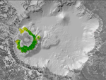 |
Movie 2. Fly-through movie showing the distribution of the bryophyte mat (moss) over the Wizard Island platform
Green shades show thicker, continuous mats of moss, whereas yellow shades show areas with thinner, patchy coverage. The red dots show points where moss was observed during the August 2006 camera sled ground-truthing operations and the light blue dots show points where detritus was observed. The gray-scale lake floor was generated from the 2000 multibeam bathymetry data and the land area was generated by draping digital orthophotographs (DOQs) over U.S. Geological Survey 10-m digital elevation models (DEMs). The movie starts by looking straight down over the lake and then zooms toward Wizard Island. The movie flies completely around Wizard Island showing the distribution of the moss and ends looking west over Ryodacite Dome. View Movie (23.7 Mb) Download Movie (23.6 Mb) |
For more information contact: Peter Dartnell
