Multibeam Sonar Mapping and Modeling of a Submerged Bryophyte Mat in Crater Lake, Oregon
Figures
 |
Figure 1. Crater Lake location map
Shaded relief map of the western United States showing the location of Crater Lake in the Cascade Range of western Oregon. View Full-Size Image (172 Kb) |
 |
Figure 2. Deep-Water, Bryophyte Moss within Crater Lake, Oregon
Sample photographs of the deep-water, bryophyte mat (moss) found in Crater Lake. View Full-Size Image (500 Kb) |
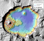 |
Figure 3. Shaded-Relief Bathymetry Image of Crater Lake, Oregon
The colored region is the lake floor, while the gray region is the surrounding mountains and Wizard Island. The width of the lake is about 9 km (5.6 mi). The reds and yellows show the shallower depths of the lake, whereas the greens and blues show the deeper depths. The gray land area is generated from USGS 7.5-min digital elevation models (DEM's). Crater Lake occupies a caldera in Mount Mazama, a Cascade Range volcano that once stood about 3,700 m (12,000 ft). Mount Mazama erupted about 7,700 years ago and soon after, collapsed upon itself to form the caldera shown in this view. This image also shows the August 2006 camera sled (light blue) and ROV (dark blue) transects used to ground-truth the moss distribution model in this report. View Full-Size Image (340 Kb) |
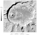 |
Figure 4. Acoustic Backscatter Image of Crater Lake, Oregon
The surrounding land is a shaded-relief topography image generated from USGS 7.5 minute DEM's. In the backscatter image, brighter contrasts are stronger acoustic returns from the lake floor, possibly rock, whereas darker contrasts are weaker acoustic returns from the lake floor, possibly soft sediment. In the backscatter amplitude gray-level key, dB (decibels) is the intensity of the backscattered acoustic pulse. View Full-Size Image (528 Kb) |
 |
Figure 5. Summer 2006 Camera Sled Operations within Crater Lake, Oregon
Camera sled operations during the summer 2006 ground-truthing cruise. This photograph shows the USGS camera sled with two regular video cameras, a high-definition camera, and paired lasers. View Full-Size Image (136 Kb) |
 |
Figure 6. Summer 2006 Camera Sled Operations within Crater Lake, Oregon
Camera sled operations during the summer 2006 ground-truthing cruise. This photograph shows the real-time video feed to the RV Neuston that is used to fly the sled and to make real-time lake floor observations (Robert Collier, OSU in photo). View Full-Size Image (136 Kb) |
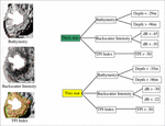 |
Figure 7. Moss Distribution Model for Crater Lake, Oregon
Moss distribution model or decision tree mapping the distribution of "thick" and "thin" mat of moss in Crater Lake. The model is built in ERDAS Imagine software. View Full-Size Image (164 Kb) |
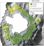 |
Figure 8. Coverage of Moss Over Wizard Island Platform, Crater Lake, Oregon
The distribution of "continuous" or thick and "patchy" or thin moss over the Wizard Island Platform. View Full-Size Image (256 Kb) |
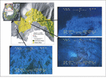 |
Figure 9. Comparison between predicted distribution of moss and video observations, Crater Lake, Oregon
Comparisons between video stills captured from video collected along the northern side of Wizard Island and the moss map. View Full-Size Image (256 Kb) |
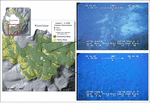 |
Figure 10. Comparison between predicted distribution of moss and video observations, Crater Lake, Oregon
Comparisons between video stills captured from video collected along the southern side of Wizard Island and the moss map. View Full-Size Image (252 Kb) |
For more information contact: Peter Dartnell

