Data Series 437
· Abstract · Introduction—Video of Exploration and Production Through Time · Undiscovered Oil and Gas Resources in the Southwestern Wyoming Province · Undiscovered Gas in the Mesaverde Total Petroleum System · The Almond Continuous Gas Assessment Unit · The Rock Springs–Ericson Gas Assessment Unit · Undiscovered Gas in the Mesaverde–Lance–Fort Union Composite Total Petroleum System · The Mesaverde–Lance–Fort Union Continuous Gas Assessment Unit · Undiscovered Gas in the Lewis Total Petroleum System · The Lewis Continuous Gas Assessment Unit · Undiscovered Gas in the Hilliard-Baxter-Mancos Total Petroleum System · The Hilliard-Baxter-Mancos Continuous Gas Assessment Unit · Undiscovered Gas in the Mowry Composite Total Petroleum System · The Mowry Continuous Gas Assessment Unit · Undiscovered Gas in the Lance–Fort Union Composite Total Petroleum System · The Lance–Fort Union Continuous Gas Assessment Unit · Reservoirs That Contain the Majority of Undiscovered Gas Resources |
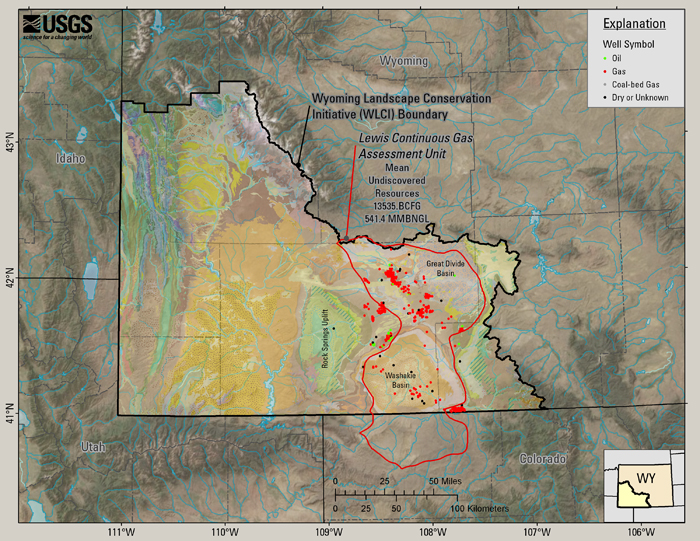
The Lewis Continuous Gas Assessment Unit (13.5 TCFG)Hettinger and Roberts (2005) report that over its extent, about 18 to 69 percent of the Lewis Continuous Gas AU has potential for additions to reserves in the next 30 years. These areas are estimated to contain between 8,765 and 19,667 BCFG, with a calculated mean of about 13,536 BCFG (Hettinger and Roberts, 2005). Gas discoveries in the next 30 years are likely to be similar in size to historical discoveries, but success ratios are expected to be significantly higher owing to improved exploration strategies, improved completion techniques, and an improved understanding of the basin-centered system (Hettinger and Roberts, 2005). Drilling success ratios are anticipated to range from 80 to 90 percent (with a median of 85 percent, Hettinger and Roberts, 2005). In Great Divide Basin, the Lewis Shale contains sandstones that were cited specifically as examples of stratigraphic sweet spots (Law, 2002, p. 1913), which are local areas of enhanced reservoir quality. Although about 600 BCFG has been produced from the Lewis Shale (Doelger and others, 1999), its production is impossible to determine precisely due to commingling with other formations (Hettinger and Roberts, 2005). The Lewis Continuous Gas AU occupies the deeper parts of the basin that are characterized by an overpressured, gas-saturated, basin-centered system (Hettinger and Roberts, 2005). The deep-basin accumulations may have the best reservoir potential for stratigraphic trapping because they contain laterally continuous basin-floor sandstones overlain by deep-water shales that provide good seals (Pyles, 2000; Pyles and Slatt, 2000). Figure 14 shows the outline of the Lewis Continuous Gas AU, the mean estimate of undiscovered gas and gas liquids in that AU, and wells from the WOGCC that have a reservoir name of Lewis and a completion date of 2001 or earlier.
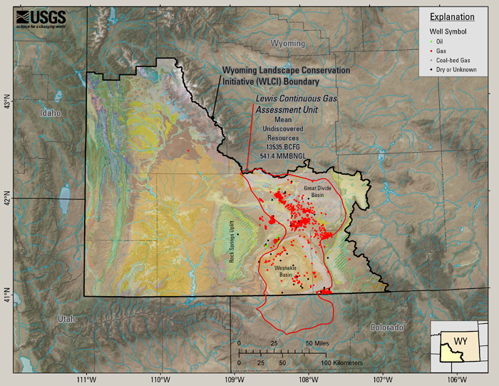
Figure 14. Lewis Shale wells at the time of the assessment (through 2001). Figure 15 includes the same data as figure 14, with post-2001 wells added to show how drilling of the Lewis Shale has progressed to the spring of 2008 (WOGCC).
Figure 15. Lewis Shale wells as of spring, 2008. Since the 2002 assessment, 354 additional wells have been completed in the Lewis Shale (WOGCC). |

![]() U.S. Department of the Interior |
U.S. Geological Survey
U.S. Department of the Interior |
U.S. Geological Survey
URL: http://pubsdata.usgs.gov/pubs/ds/437/html/lewisau.html
Page Contact Information: GS Pubs Web Contact
Page Last Modified: Monday, 28-Nov-2016 14:30:27 EST