Data Series 437
· Abstract · Introduction—Video of Exploration and Production Through Time · Undiscovered Oil and Gas Resources in the Southwestern Wyoming Province · Undiscovered Gas in the Mesaverde Total Petroleum System · The Almond Continuous Gas Assessment Unit · The Rock Springs–Ericson Gas Assessment Unit · Undiscovered Gas in the Mesaverde–Lance–Fort Union Composite Total Petroleum System · The Mesaverde–Lance–Fort Union Continuous Gas Assessment Unit · Undiscovered Gas in the Lewis Total Petroleum System · The Lewis Continuous Gas Assessment Unit · Undiscovered Gas in the Hilliard-Baxter-Mancos Total Petroleum System · The Hilliard-Baxter-Mancos Continuous Gas Assessment Unit · Undiscovered Gas in the Mowry Composite Total Petroleum System · The Mowry Continuous Gas Assessment Unit · Undiscovered Gas in the Lance–Fort Union Composite Total Petroleum System · The Lance–Fort Union Continuous Gas Assessment Unit · Reservoirs That Contain the Majority of Undiscovered Gas Resources |
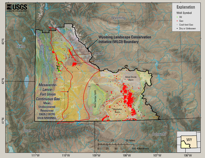
The Mesaverde–Lance–Fort Union Continuous Gas Assessment Unit (13.6 TCFG)The Mesaverde–Lance–Fort Union Continuous Gas AU encompasses the deeper part of the Composite TPS where thermal maturities at the base of the Rock Springs Formation and equivalent rocks are 0.8 percent Ro or greater (Finn and others, 2005). Two gas fields, Jonah and Pinedale, are included in the Mesaverde–Lance–Fort Union continuous gas AU (Finn and others, 2005). Figure 12 shows the extent of the Mesaverde–Lance–Fort Union Continuous Gas AU, the mean estimate of undiscovered gas and gas liquids in that AU, the Jonah and Pinedale gas fields, and wells from the WOGCC that produce from or terminate in units of the Mesaverde–Lance–Fort Union Composite TPS and have a completion date of 2001 or earlier. Notice that wells that produce from the Mesaverde Group appear between the Great Divide Basin and the Washakie Basin in the area occupied by the Almond Continuous Gas AU. These wells that are attributed in the database as producing from the Mesaverde, most likely produce from the Almond bar sandstones within the Mesaverde Group.
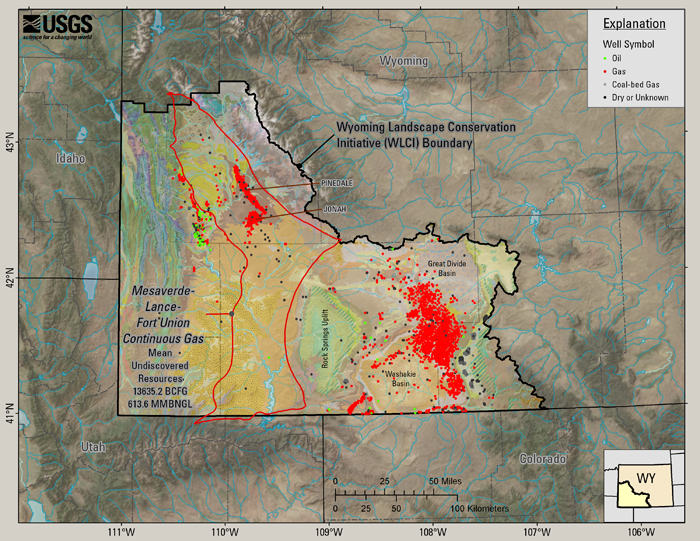
Figure 12. Mesaverde Group, Lance and Fort Union Formation wells at the time of the assessment (through 2001). Figure 13 includes the same data as figure 12, with post-2001 wells added to show how, according to the WOGCC wells database, drilling of the Mesaverde Group, the Lance Formation and the Fort Union Formation has progressed to the spring of 2008.
Figure 13. Mesaverde Group, Lance and Fort Union Formation wells as of spring, 2008. Since the 2002 assessment, 4,162 additional wells have been completed in the Mesaverde Group, Lance and Fort Union Formations, 300 of which are shown to have produced from or terminated in coal beds (WOGCC). |

![]() U.S. Department of the Interior |
U.S. Geological Survey
U.S. Department of the Interior |
U.S. Geological Survey
URL: http://pubsdata.usgs.gov/pubs/ds/437/html/mesalanceftau.html
Page Contact Information: GS Pubs Web Contact
Page Last Modified: Monday, 28-Nov-2016 14:30:17 EST