Data Series 437
· Abstract · Introduction—Video of Exploration and Production Through Time · Undiscovered Oil and Gas Resources in the Southwestern Wyoming Province · Undiscovered Gas in the Mesaverde Total Petroleum System · The Almond Continuous Gas Assessment Unit · The Rock Springs–Ericson Gas Assessment Unit · Undiscovered Gas in the Mesaverde–Lance–Fort Union Composite Total Petroleum System · The Mesaverde–Lance–Fort Union Continuous Gas Assessment Unit · Undiscovered Gas in the Lewis Total Petroleum System · The Lewis Continuous Gas Assessment Unit · Undiscovered Gas in the Hilliard-Baxter-Mancos Total Petroleum System · The Hilliard-Baxter-Mancos Continuous Gas Assessment Unit · Undiscovered Gas in the Mowry Composite Total Petroleum System · The Mowry Continuous Gas Assessment Unit · Undiscovered Gas in the Lance–Fort Union Composite Total Petroleum System · The Lance–Fort Union Continuous Gas Assessment Unit · Reservoirs That Contain the Majority of Undiscovered Gas Resources |
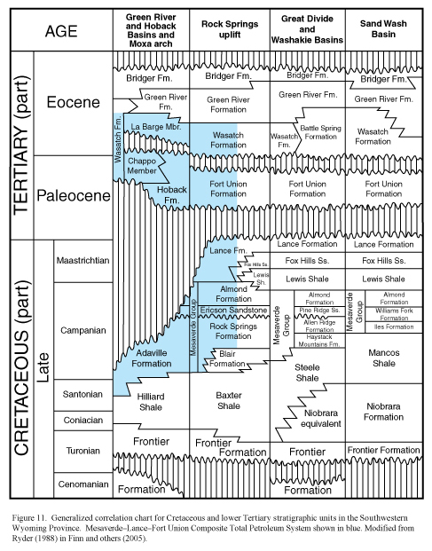
Undiscovered Gas in the Mesaverde–Lance–Fort Union Composite Total Petroleum SystemFor the 2002 assessment, the Mesaverde–Lance–Fort Union Composite TPS is considered as one total petroleum system because all of the units were deposited in a nonmarine continental setting and contain similar gas-prone source rocks, and because there is no regional seal within the entire stratigraphic succession to inhibit the vertical migration of gas (Finn and others, 2005). In the generalized stratigraphic cross section and generalized correlation chart (fig. 10), where the Lewis Shale is present, to the east, the same stratigraphic interval is subdivided into three TPSs in ascending order: the Mesaverde TPS, the Lewis TPS, and the Lance–Fort Union Composite TPS (Finn and others, 2005). The upper limit of the Composite TPS is placed at the base of the lowest regionally extensive lacustrine shale seal in the Wasatch or Green River Formation (Finn and others, 2005).
|

![]() U.S. Department of the Interior |
U.S. Geological Survey
U.S. Department of the Interior |
U.S. Geological Survey
URL: http://pubsdata.usgs.gov/pubs/ds/437/html/mesalanceft.html
Page Contact Information: GS Pubs Web Contact
Page Last Modified: Monday, 28-Nov-2016 14:30:29 EST