Skip past header information
USGS - science for a changing world

U.S. Geological Survey Data Series 469

Seabed Photographs, Sediment Texture Analyses, and Sun-illuminated Sea Floor Topography in the Stellwagen Bank National Marine Sanctuary Region off Boston, Massachusetts


Description of Sea-Floor Topography and Geographic Names

Skip past contents information

Sea-Floor Topography

A map showing the quadrangles within the Stellwagen Bank National Marine Sanctuary

Location map showing the 18 quadrangles in the Stellwagen Bank region.

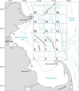
Maps showing the sea-floor topography of the Stellwagen Bank National Marine Sanctuary region have been published in both paper and digital formats: http://woodshole.er.usgs.gov/project-pages/stellwagen/stellwagenbank.html. An 18-map series showing the sun-illuminated topography of each of the quadrangles (scale 1:25,000), including a description of seabed features, was published on paper in 1999-2001 (USGS Maps I-2701 to 2718). These maps are included here in digital (PDF) format with separate files of the descriptive text. During the mapping project, many seabed features were named for the first time, and subsequent maps showing the entire 18-quadrangle region (scale 1:60,000) display these names. Refer to USGS Scientific Investigations Maps 2840-A or -B to see the locations of named features.

Topographic Maps

To view all of the geographic names in Stellwagen Bank National Marine Sanctuary region, choose either of the two maps below to download.

USGS Scientific Investigations Map 2840-A (sea-floor topography; 1:60,000)

USGS Scientific Investigations Map 2840-B (sun-illuminated sea-floor topography; 1:60,000)

To view and/or download a 1:25,000 map of an individual quadrangle showing sun-illuminated topography and/or a description of its seabed topography, choose from the table below.

View printing instructions here.

Quadrangle
Sun-Illuminated topographic map, 1:25,000 (PDF)
Description of topographic features (PDF)
1
USGS Map I-2701 (2.5 MB)  Quadrangle 1 description of topographic features (33 KB)
2
USGS Map I-2702 (2.3 MB) Quadrangle 2 description of topographic features (31 KB)
3
USGS Map I-2703 (2.2 MB) Quadrangle 3 description of topographic features (31 KB)
4
USGS Map I-2704 (2.6 MB) Quadrangle 4 description of topographic features (34 KB)
5
USGS Map I-2705 (2.4 MB) Quadrangle 5 description of topographic features (33 KB)
6
USGS Map I-2706 (2.7 MB) Quadrangle 6 description of topographic features (32 KB)
7
USGS Map I-2707 (2.7 MB) Quadrangle 7 description of topographic features (35 KB)
8
USGS Map I-2708 (2.6 MB) Quadrangle 8 description of topographic features (33 KB)
9
USGS Map I-2709 (2.9 MB) Quadrangle 9 description of topographic features (32 KB)
10
USGS Map I-2710 (2.8 MB) Quadrangle 10 description of topographic features (36 KB)
11
USGS Map I-2711 (3.3 MB) Quadrangle 11 description of topographic features (33 KB)
12
USGS Map I-2712 (3.1 MB) Quadrangle 12 description of topographic features (33 KB)
13
USGS Map I-2713 (2.7 MB) Quadrangle 13 description of topographic features (37 KB)
14
USGS Map I-2714 (3.0 MB) Quadrangle 14 description of topographic features (33 KB)
15
USGS Map I-2715 (3.6 MB) Quadrangle 15 description of topographic features (33 KB)
16
USGS Map I-2716 (2.8 MB) Quadrangle 16 description of topographic features (33 KB)
17
USGS Map I-2717 (2.9 MB) Quadrangle 17 description of topographic features (34 KB)
18
USGS Map I-2718 (3.6 MB) Quadrangle 18 description of topographic features (32 KB)


Geographic Names

Named geographic features that lie within the 18 quadrangles of the Stellwagen Bank National Marine Sanctuary region are listed below by quadrangle. Most of these features were named during the mapping project, and a link to the official description is provided. Some feature names are historical; no official description is available. An alphabetized list of names and descriptions is available at http://woodshole.er.usgs.gov/project-pages/stellwagen/html/geonames.html.

Quadrangle
Geographic name
Description
Quadrangle 1
Stellwagen Basin historical name; no detailed official description available
Quadrangle 2
Little Stellwagen Basin historical name; no detailed official description available
Race Point Channel http://woodshole.er.usgs.gov/project-pages/stellwagen/html/geonames.html#racepointchannel
Southwest Corner http://woodshole.er.usgs.gov/project-pages/stellwagen/html/geonames.html#southwestcorner
Stellwagen Bank historical name; no detailed official description available
Stellwagen Basin historical name; no detailed official description available
Quadrangle 3
Little Stellwagen Basin historical name; no detailed official description available
Race Point Channel http://woodshole.er.usgs.gov/project-pages/stellwagen/html/geonames.html#racepointchannel
South Ninety Bank http://woodshole.er.usgs.gov/project-pages/stellwagen/html/geonames.html#sninetybank
Stellwagen Bank historical name; no detailed official description available
Quadrangle 4
East Breakwater Bank http://woodshole.er.usgs.gov/project-pages/stellwagen/html/geonames.html#ebreakwaterbank
Long Bank http://woodshole.er.usgs.gov/project-pages/stellwagen/html/geonames.html#longbank
Southwestern Spur http://woodshole.er.usgs.gov/project-pages/stellwagen/html/geonames.html#southwesternspur
Stellwagen Basin historical name; no detailed official description available
Quadrangle 5
Fifteen Bank http://woodshole.er.usgs.gov/project-pages/stellwagen/html/geonames.html#fifteenbank
Southwestern Spur http://woodshole.er.usgs.gov/project-pages/stellwagen/html/geonames.html#southwesternspur
Stellwagen Basin historical name; no detailed official description available
Western Spur http://woodshole.er.usgs.gov/project-pages/stellwagen/html/geonames.html#westernspur
Quadrangle 6
East Ninety Bank http://woodshole.er.usgs.gov/project-pages/stellwagen/html/geonames.html#eastninetybank
Middle Ninety Bank http://woodshole.er.usgs.gov/project-pages/stellwagen/html/geonames.html#middleninetybank
Ninety Meter Banks http://woodshole.er.usgs.gov/project-pages/stellwagen/html/geonames.html#ninetymeterbanks
North Ninety Bank http://woodshole.er.usgs.gov/project-pages/stellwagen/html/geonames.html#northninetybank
South Ninety Bank http://woodshole.er.usgs.gov/project-pages/stellwagen/html/geonames.html#sninetybank
Stellwagen Bank historical name; no detailed official description available
Quadrangle 7
Compass Rose Bank http://woodshole.er.usgs.gov/project-pages/stellwagen/html/geonames.html#compassrosebank
East Breakwater Bank http://woodshole.er.usgs.gov/project-pages/stellwagen/html/geonames.html#ebreakwaterbank
Lower Stellwagen Bank http://woodshole.er.usgs.gov/project-pages/stellwagen/html/geonames.html#lowerstellwagenbank
Northwest Corner http://woodshole.er.usgs.gov/project-pages/stellwagen/html/geonames.html#northwestcorner
Stellwagen Bank historical name; no detailed official description available
Stellwagen Basin historical name; no detailed official description available
The Breakwater http://woodshole.er.usgs.gov/project-pages/stellwagen/html/geonames.html#breakwater
The Rockpile http://woodshole.er.usgs.gov/project-pages/stellwagen/html/geonames.html#therockpile
West Breakwater Bank http://woodshole.er.usgs.gov/project-pages/stellwagen/html/geonames.html#wbreakwaterbank
Quadrangle 8
Stellwagen Bank historical name; no detailed official description available
Stellwagen Basin historical name; no detailed official description available
Western Edge http://woodshole.er.usgs.gov/project-pages/stellwagen/html/geonames.html#westernedge
Western Spur http://woodshole.er.usgs.gov/project-pages/stellwagen/html/geonames.html#westernspur
Quadrangle 9
Stellwagen Bank historical name; no detailed official description available
Quadrangle 10
Ellipse Bank http://woodshole.er.usgs.gov/project-pages/stellwagen/html/geonames.html#ellipsebank
Gloucester Bank http://woodshole.er.usgs.gov/project-pages/stellwagen/html/geonames.html#gloucesterbank
Gloucester Basin http://woodshole.er.usgs.gov/project-pages/stellwagen/html/geonames.html#gloucesterbasin
Lower Stellwagen Bank http://woodshole.er.usgs.gov/project-pages/stellwagen/html/geonames.html#lowerstellwagenbank
Polygon Bank http://woodshole.er.usgs.gov/project-pages/stellwagen/html/geonames.html#polygonbank
Stenos Basin http://woodshole.er.usgs.gov/project-pages/stellwagen/html/geonames.html#stenosbasin
Quadrangle 11
Creed Basin http://woodshole.er.usgs.gov/project-pages/stellwagen/html/geonames.html#creedbasin
Creed Ridge http://woodshole.er.usgs.gov/project-pages/stellwagen/html/geonames.html#creedridge
East Tillies Basin http://woodshole.er.usgs.gov/project-pages/stellwagen/html/geonames.html#etilliesbasin
Gloucester Basin http://woodshole.er.usgs.gov/project-pages/stellwagen/html/geonames.html#gloucesterbasin
Little Tillies Bank http://woodshole.er.usgs.gov/project-pages/stellwagen/html/geonames.html#ltilliesbasin
Northern Valley http://woodshole.er.usgs.gov/project-pages/stellwagen/html/geonames.html#northernvalley
Polygon Bank http://woodshole.er.usgs.gov/project-pages/stellwagen/html/geonames.html#polygonbank
Tillies Bank http://woodshole.er.usgs.gov/project-pages/stellwagen/html/geonames.html#tilliesbank
West Tillies Basin http://woodshole.er.usgs.gov/project-pages/stellwagen/html/geonames.html#wtilliesbasin
Y Valley http://woodshole.er.usgs.gov/project-pages/stellwagen/html/geonames.html#yvalley
Quadrangle 12
Triple Valley http://woodshole.er.usgs.gov/project-pages/stellwagen/html/geonames.html#triplevalley
Y Valley http://woodshole.er.usgs.gov/project-pages/stellwagen/html/geonames.html#yvalley
Quadrangle 13
Gloucester Bank http://woodshole.er.usgs.gov/project-pages/stellwagen/html/geonames.html#gloucesterbank
Gloucester Basin http://woodshole.er.usgs.gov/project-pages/stellwagen/html/geonames.html#gloucesterbasin
Jeffreys Ledge historical name; no detailed official description available
Polygon Bank http://woodshole.er.usgs.gov/project-pages/stellwagen/html/geonames.html#polygonbank
Polygon Basin http://woodshole.er.usgs.gov/project-pages/stellwagen/html/geonames.html#polygonbasin
Salvages Basin http://woodshole.er.usgs.gov/project-pages/stellwagen/html/geonames.html#salvagesbasin
Thacher Bank http://woodshole.er.usgs.gov/project-pages/stellwagen/html/geonames.html#thacherbank
Thacher Basin http://woodshole.er.usgs.gov/project-pages/stellwagen/html/geonames.html#thacherbasin
Quadrangle 14
Creed Basin http://woodshole.er.usgs.gov/project-pages/stellwagen/html/geonames.html#creedbasin
Creed Ridge http://woodshole.er.usgs.gov/project-pages/stellwagen/html/geonames.html#creedridge
East Tillies Basin http://woodshole.er.usgs.gov/project-pages/stellwagen/html/geonames.html#etilliesbasin
Jeffreys Ledge historical name; no detailed official description available
North Tillies Basin http://woodshole.er.usgs.gov/project-pages/stellwagen/html/geonames.html#northtilliesbasin
Polygon Basin http://woodshole.er.usgs.gov/project-pages/stellwagen/html/geonames.html#polygonbasin
Tillies Bank http://woodshole.er.usgs.gov/project-pages/stellwagen/html/geonames.html#tilliesbank
West Tillies Basin http://woodshole.er.usgs.gov/project-pages/stellwagen/html/geonames.html#wtilliesbasin
Quadrangle 15
Y Valley http://woodshole.er.usgs.gov/project-pages/stellwagen/html/geonames.html#yvalley
Quadrangle 16
Jeffreys Ledge historical name; no detailed official description available
Scantum Basin historical name; no detailed official description available
The Stone Wall http://woodshole.er.usgs.gov/project-pages/stellwagen/html/geonames.html#stonewall
Quadrangle 17
East Pigeon Hill http://woodshole.er.usgs.gov/project-pages/stellwagen/html/geonames.html#epigeonhill
First Basin http://woodshole.er.usgs.gov/project-pages/stellwagen/html/geonames.html#firstbasin
Jeffreys Ledge historical name; no detailed official description available
Rose and Lucys Basin http://woodshole.er.usgs.gov/project-pages/stellwagen/html/geonames.html#roselucysbasin
Sanctuary Hill http://woodshole.er.usgs.gov/project-pages/stellwagen/html/geonames.html#sanctuaryhill
Scantum Basin historical name; no detailed official description available
Scantum Spur http://woodshole.er.usgs.gov/project-pages/stellwagen/html/geonames.html#scantumspur
The Cove http://woodshole.er.usgs.gov/project-pages/stellwagen/html/geonames.html#thecove
West Pigeon Hill http://woodshole.er.usgs.gov/project-pages/stellwagen/html/geonames.html#wpigeonhill
Quadrangle 18
East Hill http://woodshole.er.usgs.gov/project-pages/stellwagen/html/geonames.html#easthill
Pigeon Basin http://woodshole.er.usgs.gov/project-pages/stellwagen/html/geonames.html#pigeonbasin
Sanctuary Basin historical name; no detailed official description available
Sanctuary Hill http://woodshole.er.usgs.gov/project-pages/stellwagen/html/geonames.html#sanctuaryhill


Printable version in PDF format

To view files in PDF format, download a free copy of Adobe Reader.

Skip USGS links group

Accessibility FOIA Privacy Policies and Notices

Take Pride in America logo USAGov logo U.S. Department of the Interior | U.S. Geological Survey
End of USGS links group