U.S. Geological Survey Data Series 469
Seabed Photographs, Sediment Texture Analyses, and Sun-illuminated Sea Floor Topography in the Stellwagen Bank National Marine Sanctury Region off Boston, Massachusetts
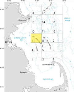
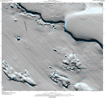
IntroductionThis report makes available for viewing and downloading digital photographs of the seabed collected by the U.S. Geological Survey in Quadrangle 7 of the Stellwagen Bank National Marine Sanctuary region during the period 1995 to 2004. In all, 1,728 photos of the seabed are available for viewing. A gallery of seabed photographs typical of the entire Stellwagen Bank region can be viewed for reference at http://woodshole.er.usgs.gov/project-pages/stellwagen/photos/phothome.html. In addition, 125 sediment samples were collected in Quadrangle 7 from 1996 to 2003. For sites where both photographs and sediment samples were collected, grain-size analyses provide information that will help in interpreting the images. All sediment grain-size and seabed-photograph data collected in this quadrangle during the project are available in this report in Excel spreadsheet format and ESRI shapefile format with accompanying Federal Geographic Data Committee compliant metadata for download from the Data Catalog page. Click here to download USGS Map I-2707 showing sun-illuminated topography of Quadrangle 7. (View printing instructions here.) |
|||||
Seabed PhotographsAll photographs associated with this publication are hosted on the Woods Hole Science Center photograph database at http://nantucket.er.usgs.gov. You can access seabed photographs for Quadrangle 7 by four methods: 1. If you wish to select photos geographically/spatially, an interactive topographic map in PDF format is provided (see the first link and instructions in the table at right). This interactive map shows the locations (station names in red) where the photos were taken. Clicking on a station number displays the photos taken at that location. Photos are presented as thumbnails and as high resolution (3072 x 2048 pixels) JPEG images. 2. For a direct link to photographs in Quadrangle 7, see the second link and instructions in the table at right. Photographs in the online database are sorted alphabetically by file name. 3. Alternatively, all photographs for Quadrangle 7 can be downloaded to your computer and viewed with an image viewer. Two resolutions are provided in zip format on the Data Catalog page: medium-resolution JPEG images (1536 x 1024 pixels) and high-resolution JPEG images (3072 x 2048 pixels). When the download is complete, you will need to extract the images by using an unzip program. Embedded in the JPEG images are metadata such as date, time, location, water depth, instrumentation, and other information. To display the image metadata, you will need to use a viewer that supports Exchangeable Image File Format (EXIF). 4. Photographs may also be viewed directly from the sb_photolocs ESRI shapefile by using the hotlink tool. URLs link all station photographs to their respective locations in the online photograph collection. To access the photographs, users must be connected to the Internet. To download the ESRI shapefile, visit the Data Catalog page. For information on photograph collection and processing and an explanation of the Excel spreadsheet columns, see the Seabed Photograph Collection and Processing section. |
|||||
Sediment AnalysesAn Excel spreadsheet displaying the results of analyses of all sediment samples from the Stellwagen Bank National Marine Sanctuary region and a shapefile of all samples with accompanying metadata can be downloaded from the Data Catalog page. Collection and analysis methods, as well as a description of the spreadsheet columns, can be found on the Seabed Sediment Collection, Processing, and Analysis page. |
|||||