U.S. Geological Survey Data Series 671
1U.S. Geological Survey, St. Petersburg, FL 33701.
2Jacobs Technology Inc., Tampa, FL 33609.
3U.S. Army Corps of Engineers, Mobile, AL 36628.
U.S. Department of the Interior
U.S. Geological Survey
U.S. Army Corp of Engineers - Mobile, AL
Publications are available from USGS Information Services, Box 25286, Federal Center, Denver, CO 80225-0046 (telephone 1-888-ASK-USGS; e-mail: infoservices@usgs.gov).
Contents: |
||||
 |
||||
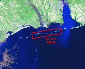
Figure 1. USGS Cruise 10CCT03 study area, offshore Gulf Islands National Seashore, Mississippi from East Ship Island, Mississippi, to Dauphin Island, Alabama. |
||||
This DVD publication was prepared by an agency of the United States Government. Although these data have been processed successfully on a computer system at the U.S. Geological Survey, no warranty expressed or implied is made regarding the display or utility of the data on any other system, or for general or scientific purposes, nor shall the act of distribution imply any such warranty. The U.S. Geological Survey shall not be held liable for improper or incorrect use of the data described and (or) contained herein. Reference herein to any specific commercial product, process, or service by trade name, trademark, manufacturer, or otherwise does not constitute or imply its endorsement, recommendation, or favoring by the United States Government or any agency thereof.
This disc is readable on any computing platform that has standard DVD driver software installed. The minimum software requirements are a Web browser and Adobe Reader.
In April of 2010, the U.S. Geological Survey (USGS) conducted a geophysical survey from the east end of East Ship Island, Miss., extending to the middle of Dauphin Island, Ala. (fig. 1). This survey had a dual purpose: (1) to interlink previously conducted nearshore geophysical surveys (shoreline to ~2 km) with those of offshore surveys (~2
This report serves as an archive of the processed multibeam bathymetry and side scan sonar (SSS) data. Data products herein include gridded and interpolated digital depth surfaces, seabed surface backscatter imagery, and x,y,z data products for both multibeam bathymetry and side scan sonar imagery. Additional files include trackline maps, navigation files, geograpahic information system (GIS) files, Field Activity Collection System (FACS) logs, and formal Federal Geographic Data Committee (FGDC) metadata. Scanned images of the handwritten FACS logs and digital FACS logs are also provided as PDF files. Refer to the Acronyms page for description of acronyms and abbreviations used in this report or hold the cursor over an acronym for a pop-up explanation.
The USGS St. Petersburg Coastal and Marine Science Center assigns a unique identifier to each cruise or field activity. For example, 10CCT03 tells us the data were collected in 2010 for the Coastal Change and Transport (CCT) study and the data were collected during the third (03) field activity for that project in that calendar year. Refer to http://walrus.wr.usgs.gov/infobank/programs/html/definition/activity.html for a detailed description of the method used to assign the field activity ID.
Data were collected aboard the U.S. Army Corps of Engineers (USACE) SV Irvington, a 56-foot (ft) Kvichak Marine Industries, Inc., catamaran (fig. 2). Side scan sonar and multibeam bathymetry data were collected simultaneously along the tracklines. The side scan sonar towfish was towed off the starboard side just slightly behind the vessel, close to the seafloor. The multibeam transducer was attached to a retractable strut-arm lowered between the catamaran hulls. Navigation was acquired with an Applanix POS MV and differentially corrected using the broadcast signal from a local National Geodetic Survey (NGS) Continuously Operating Reference Station (CORS) beacon. See the digital FACS equipment log for details about the acquisition equipment used. Raw datasets were stored digitally and processed using HYPACK Inc., HYSWEEP software at the USACE Mobile, Ala., District office. For more information on processing refer to the Equipment and Processing page. Chirp seismic data were also collected during this survey and are archived separately.
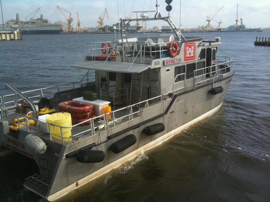
Figure 2. Photograph of the USACE SV Irvington
To access the information contained on this disc, use a Web browser to open the file index.html. This report is divided into eight sections: Acronyms, Figures and Tables, Navigation, Equipment and Processing, Images, Logs,
The Framework Group (FRAWG) at the USGS St. Petersburg Coastal and Marine Science Center would like to thank the following for their efforts:
Funding for this project was provided by the Mississippi Coastal Improvements Program (MsCIP) and the Northern Gulf of Mexico Ecosystem Change and Hazard Susceptibility Program (NGOM).
http://ngom.usgs.gov/gomsc/mscip/
Captains Fred Roberts and Reid Boa of the SV Irvington, U.S. Army Corps of Engineers, Mobile, Ala., District for their hard work and hospitality.
http://www.nap.usace.army.mil/mdc/fs11.htm
USGS St. Petersburg Coastal and Marine Science Center supporting staff:
Hayes, M.P., and Barclay, P.J., 2003, The effects of multipath on a bathymetric synthetic aperture sonar using belief propagation, In Bailey, D.G., ed., Proceedings of Image and Vision Computing New Zealand 2003, Novermber 26-28: Palmerston North, New Zealand, Massey University, 6 p.
HYPACK, Inc., 2009, HYPACK training notes, presentations and sample projects in HYPACK 2009, January 11-14: San Diego, Calif., DVD.
DeWitt, N.T., Flocks, J.G., Pfeiffer, W.R., Gibson, J.N., and Wiese, D.S., 2012, Archive of side scan sonar and swath bathymetry data collected during USGS cruise 10CCT03 offshore of the Gulf Islands National Seashore, Mississippi, from East Ship Island, Mississippi, to Dauphin Island, Alabama, April 2010: U.S. Geological Survey Data Series 671, 1 DVD.

![]() U.S. Department of the Interior |
U.S. Geological Survey
U.S. Department of the Interior |
U.S. Geological Survey
URL: http://pubsdata.usgs.gov/pubs/ds/671/index.html
Page Contact Information: GS Pubs Web Contact
Page Last Modified: Monday, 28-Nov-2016 18:39:37 EST