Fact Sheet 2006-3138
U.S. GEOLOGICAL SURVEY
Fact Sheet 2006-3138
By Wayne R. Belcher and Alan H. Welch
Water is a precious commodity, especially in the arid southwest region of the United States, where there is a limited supply of surface water and ground water. Growing populations have increased the demands on this limited supply of water. In addition to water supply, many other uses for ground water exist in this region (fig. 1). Some of these uses include:
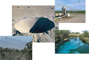
Often these uses of water compete with one another. For instance, pumping of ground water for agriculture can lower water levels in natural springs, thereby threatening the existence of aquatic animals and plants. Or pumping of ground water in water levels in natural springs, thereby threatening the existence of aquatic animals and plants. Or pumping of ground water in rural areas for municipal water supply can limit the amount of water available for agriculture.
Tools are needed to analyze the effects of these competing interests in water and to allow land managers and planners to balance the various uses. A ground-water computer model is one such tool that can be used to examine effects from pumping on water levels, spring flows, and flow paths (directions of ground-water flow). These effects can affect water availability, water-dependent ecosystems, and the movement of contaminants. A computer model can be a valuable tool for managing the water resources and for addressing complex socio-economic and political issues resulting from conflicting water uses.
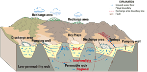
To model a ground-water system, scientists first must study the system to understand directions and rates of ground-water flow, creating a “conceptual model”. The conceptual model of ground-water flow in the Great Basin (which contains most of Nevada) consists of several interconnected, complex ground-water flow systems (fig. 2). Ground-water flow occurs in three subregions (local, intermediate, and regional). The relatively shallow and localized systems are superimposed on deeper, regional systems. Regional ground-water flows predominantly through thick Paleozoic carbonate rocks that are folded and faulted; more localized flow occurs in basin-fill and volcanic-rock units. Faults and folds can place aquifers (permeable rock) and confining units (low-permeable rock) next to each other or create zones where ground-water flow can be enhanced or restricted. Ground-water flow also can be affected by changes occurring within the rock including, but not limited to, the amount of welding in volcanic tuffs, changes in the type of sediments making up sedimentary rocks, and the chemical composition of the rock caused by the flow of hot water.
Ground water from the regional and local systems is discharged naturally by spring flow and evapotranspiration (the combination of evaporation and plant transpiration), and by pumping for agricultural, commercial, and domestic uses.
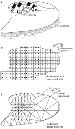
Models are simplified descriptions of physical reality and can be verbal descriptions, graphical representations, physical models, or mathematical equations. Mathematical equations, such as the ground-water flow equation, can be solved efficiently by computer programs. The ground-water flow equations are solved on a computer by two main methods—by finite differences and finite elements. Both of these methods solve the ground-water flow equations for a conceptual model (fig. 3A) across a model grid. To model a ground-water system (fig. 3A), it is divided into discrete units, or cells, consisting of a grid system with one or more layers or dimensions (fig. 4). Finite-difference grids are regular rectangular grids (fig. 3B) and finite-element grids are irregular polygonal subdivisions (fig. 3C); these grid types reflect the mathematical techniques used to solve the ground-water flow equations. These grids can represent one-, two-, or three-dimensional systems (fig. 4).
Computerized numerical methods are used with the appropriate input to define the ground-water system to create a computer (or numerical) model. For ground-water systems, model input consists of the areal extent, thickness, and altitude of aquifers (water-bearing units) and confining units (units that restrict ground-water flow) and the hydrologic properties of these units. Model input also consists of the amount, the location, and by which method water enters (recharges) and leaves (discharges) the modeled system. The definition of the amount, the location, and the method by which water enters or leaves the ground-water system describes the “boundary conditions”.
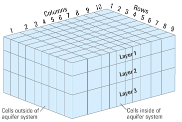
When the ground-water flow equation is solved for each cell, the water level and flow is calculated for each cell. The equation can be solved for equilibrium (steady state) or changing (transient) conditions. These modeled water levels and (or) flows then can be compared to measured water levels in wells and (or) measured flows. Model calibration consists of adjusting model inputs until there is a good match between the modeled and measured water levels/flows. The need to calibrate model inputs by trial and error is reduced greatly by parameter estimation, a mathematical process that helps calculate model inputs that best represent the natural system.
The modular, finite-difference ground-water flow modeling computer program, MODFLOW, developed by the U.S. Geological Survey (USGS), is a computer program for simulating common features in ground-water systems (Harbaugh and McDonald, 1996; Harbaugh, 2005). MODFLOW originally was constructed in the early 1980’s and has evolved continually since then with development of many new packages to model different ground-water processes. Currently, MODFLOW is the world’s most widely used program for simulating ground-water flow. More information on MODFLOW can be found in Leake (1997).
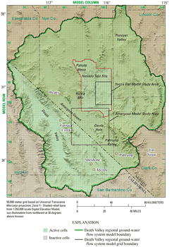
The conceptual model presented in figure 2 is the basis of several computer models that describe regional ground-water flow in Nevada. Regional-scale models examine larger ground-water systems that incorporate multiple basins and the ground-water flow between them. A regional-scale model of the carbonate-rock province of the Great Basin was developed by Prudic and others (1995). The Death Valley regional ground-water flow system model (Belcher, 2004; Faunt and others, 2004a) is another example of a regional-scale model of ground-water flow in Nevada (fig. 5).
Local-scale models examine smaller flow systems in more detail, typically with a smaller grid size and area than a regional-scale model. Local-scale models enable scientists to model a ground-water flow system in detail, capturing information that normally would be smoothed out in a regional model. The choice of a regional-scale or local-scale model depends on the scope of the scientific study. For instance, in the Amargosa Desert area in southern Nevada (figs. 5 and 6B), water levels from pumping can change rapidly over short distances and the variable geology in the basin-fill deposits greatly affects ground-water flow. Accordingly, a model with a smaller “local” grid size is needed in this type of setting (fig. 6). Boundary conditions for the edges of a local-scale model can be obtained from a regional-scale model when the regional-scale model area encompasses the local-scale model area.
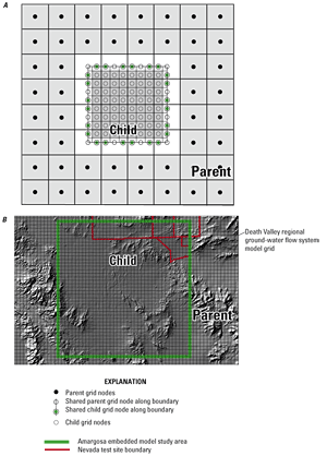
There are two ways to link local models to regional models. The first way to link them is to produce a separate local model that scientists obtain the boundary conditions for the edges of a local model from a regional model. Typically, this linkage is one way and only water levels or flows (but not both) are specified at the boundary.
The second way to link local- and regional-scale models is to produce an “embedded” model. The embedded model is a local model that is “coupled” to the regional model, allowing information on ground-water flow to be transferred between them, in effect calibrating both models simultaneously. The local model has a finer-scale grid of an area within a regional-scale model. The regional-scale model is known as the “parent” grid, while the embedded model (the coupled local model) is the “child” grid (fig. 6A). The embedded model is coupled to the regional model using a Local Grid Refinement (LGR) package for MODFLOW (Mehl and Hill, 2005). The advantage of LGR is that it uses a two-way linking procedure to balance water levels and flows across the boundary between the two models. Embedded models of underground test areas at Yucca Flat on the Nevada Test Site and the southern part of Amargosa Desert, both in Nye County, Nevada, currently are being developed (fig. 5).
The USGS maintains a neutral, unbiased approach to scientific data collection, interpretation, and presentation. One of the strengths of the USGS is the ability to carry out large-scale, multi-disciplinary investigations that increase our understanding of Earth and provide managers with the tools and information they need to address issues of social concern. Unlike many other government agencies, the USGS is not a regulatory or management agency and does not manage lands and natural resources and is not an advocate for public policies. The role of the USGS is to supply data and scientific interpretation that allows managers to make informed decisions about how resources are managed for society.
Maintaining a neutral, unbiased standing on management issues for natural resources has allowed the USGS to be considered an authority in the field of earth sciences within the Federal Government. USGS data and interpretations are used in judicial cases concerning resource management because we maintain an unbiased stance. Extensive quality assurance and review procedures assure that science is accurate and interpretations remain neutral.
Belcher, W.R., ed., 2004, Death Valley regional ground-water flow system, Nevada and California—Hydrogeologic framework and transient ground-water flow model: U.S. Geological Survey Scientific Investigations Report 2004–5205, 408 p, https://pubs.usgs.gov/sir/2004/5205/
Faunt, C.C., Blainey, J.B., Hill, M.C., D’Agnese, F.A., and O’Brien, G.M., 2004a, Transient numerical model, chap. F in Belcher, W.R., ed., Death Valley regional ground-water flow system, Nevada and California—Hydrogeologic framework and transient ground-water flow model: U.S. Geological Survey Scientific Investigations Report 2004–5205, p. 257–352, https://pubs.usgs.gov/sir/2004/5205/
Faunt, C.C., D’Agnese, F.A., and O’Brien, G.M., 2004b, Hydrology, chap. D in Belcher, W.R., ed., Death Valley regional ground-water flow system, Nevada and California—Hydrogeologic framework and transient ground-water flow model: U.S. Geological Survey Scientific Investigations Report 2004–5205, p. 137–163, https://pubs.usgs.gov/sir/2004/5205/
Harbaugh, A.W., 2005, MODFLOW-2005, the U.S. Geological Survey modular ground-water model— The Ground-Water Flow Process: U.S. Geological Survey Techniques and Methods 6-A16, variously paged, https://pubs.usgs.gov/tm/2005/tm6A16/
Harbaugh, A.W., and McDonald, M.G., 1996, User’s documentation for MODFLOW-96, an update to the U.S. Geological Survey modular finite-difference ground-water flow model: U.S. Geological Survey Open-File Report 96–485 56 p.
Leake, S.A., 1997, Modeling ground-water flow with MODFLOW and related programs: U.S. Geological Survey Fact Sheet 121–97, 4 p., https://pubs.usgs.gov/fs/FS-121-97/
Mehl, S.W., and Hill, M.C., 2005, MODFLOW-2005, the U.S. Geological Survey modular ground-water model—Documentation of shared node local grid refinement (LGR) and the Boundary Flow and Head (BFH) Package: U.S. Geological Survey Techniques and Methods 6-A12, 68 p., https://pubs.usgs.gov/tm/2006/tm6a12/
Mercer, J.W., and Faust, C.R., 1980, Ground-water modeling - an overview: Ground Water, v. 18, no. 3, p. 212-227.
Prudic, D.E., Harrill, J.R., and Burbey, T.J., 1995, Conceptual evaluation of regional ground-water flow in the carbonate-rock province of the Great Basin, Nevada, Utah, and adjacent states: U.S. Geological Survey Professional Paper 1409–D, 102 p.
Director
USGS, Nevada Water Science Center
2730 N. Deer Run Road
Carson City, NV 89701
email: GS-W-NVpublic-info@usgs.gov
http://nevada.usgs.gov
This report is available online in Portable Document Format (PDF). If you do not have the Adobe Acrobat PDF Reader, it is available for free download from Adobe Systems Incorporated.
Document Accessibility: Adobe Systems Incorporated has information about PDFs and the visually impaired. This information provides tools to help make PDF files accessible. These tools convert Adobe PDF documents into HTML or ASCII text, which then can be read by a number of common screen-reading programs that synthesize text as audible speech. In addition, an accessible version of Acrobat Reader 7.0 for Windows (English only), which contains support for screen readers, is available. These tools and the accessible reader may be obtained free from Adobe at Adobe Access.