Glacial Cape Cod
The geologic history of Cape Cod mostly involves the advance and retreat of the last continental ice sheet (named the Laurentide after the Laurentian region of Canada where it first formed) and the rise in sea level that followed the retreat of the ice sheet. On Cape Cod, these events occurred within the last 25,000 years, and many can be dated by using radiocarbon techniques.
Click on each figure or figure number to see a larger image
|
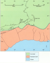
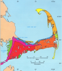
| Figure 2: The continental ice sheet advanced across Cape Cod to the islands about 23,000 years ago. Its maximum advance is marked today by gravel deposits on the continental shelf and by the outwash plains and moraines on the Islands.
|
|
|
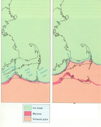
| Figure 3. Moraines and heads of outwash plains on Martha's Vineyard, Nantucket, and Cape Cod mark positions of the ice front during retreat. They also define lobes of the Laurentide ice sheet. The relationship between the deposits and lobes can be seen in this figure.
|
|
|
|
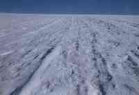
Figure 4. Up ice aerial view of the Greenland icecap. This may have been the kind of view one would have seen flying over Cape Cod about 19,000 years ago (photo by J. H.. Hartshorn). |
Sometime after 23,000 years ago, the glacier reached its maximum advance, a position marked approximately by the islands of Nantucket and Martha's Vineyard (Fig. 2). The ice sheet was characterized by lobes (Fig. 3) that occupied large basins in the bedrock surface. These lobes were responsible for the location and overall shape of Cape Cod and the islands. Thus, the western side of Cape Cod was formed by the Buzzards Bay lobe, the middle part by the Cape Cod Bay lobe, and the lower or outer Cape by the South Channel lobe, which occupied a deep basin to the east of the Cape. During the maximum ice advance the landscape, where Cape Cod was soon to be, was glacial ice to the horizon (Fig. 4).
Within a few thousand years or possibly less, the ice sheet started to retreat rapidly, and by 18,000 years ago, it had retreated away from Cape Cod and into the Gulf of Maine, which lies to the east and to the north of the Cape. Thus the retreat of the ice from the islands to a position north of Cape Cod may have taken only a few thousand years. By roughly 15,000 years ago, the ice had retreated from the Gulf of Maine and all of southern New England.
|
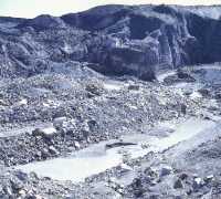
| Figure 5. Ice contact deposits of the Alaskan Malaspina Glacier. Till, boulders, and sand and gravel are underlain by the irregular surface of melting ice. Silt and clay are being deposited in ponds that occupy depressions in the ice surface (photo by J. H.. Hartshorn). |
The rock debris deposited by glaciers is called drift. It overlies bedrock that is similar to the hard rock that crops out throughout the rest of New England. On Cape Cod, the bedrock is buried by glacial deposits ranging from more than 200 to more than 600 feet thick. Drift consists of very fine to very coarse rock debris. If unstratified and unsorted, it is called glacial till. Till is deposited directly by ice and is unsorted because ice cannot separate rock fragments of different sizes. Thus, it is a mixture of all sizes of rock debris ranging from clay-sized particles to very large boulders. Stratified drift, on the other hand, is deposited by water which can separate the different sizes of rock fragments. The rock fragments are deposited in layers called strata. Gravel and sand are sorted and stratified by meltwater flowing in streams draining the glacier. The clay and silt-sized particles are carried by the meltwater streams into quiet water (glacial lakes or the sea) where they settle out according to the size of the particles; the coarsest, first, and the finest, last.
Meltwater stream sediments that are laid down over and around glacial ice are called ice-contact deposits (Fig. 5) and generally consist of sand and gravel, but locally include silt and clay, till, and large to very large boulders.
The distribution of the glacial deposits on Cape Cod is shown by the generalized geologic map (Fig. 6). Most of the drift has been fashioned into either moraines or outwash plains. Both features mark positions of the ice front. Moraines are ridges of drift formed by moving ice. Most moraines are formed when the ice front remains more or less in the same place because advance of the glacier is balanced by melting along the ice front.
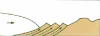
When the debris falls free of the ice, it accumulates along the ice front much like material at the end of a conveyor belt. However, the Buzzards Bay and Sandwich moraines were formed in a different way. They were formed when an advancing ice front overrode sediments it had previously deposited or sediments that were older than the last glaciation. The advancing ice thrust sheets of drift upward and forward to form a large ridge beyond the ice front. Thus, the formation of the moraine more closely resembles the work of a bulldozer rather than a conveyor belt (Fig. 7).
|
| Figure 7. Ice-Thrust Model for formation of Buzzards Bay and Sandwich glaciotectonic end moraines by advancing ice (represented by horizontal arrow). The thrust moraine is formed by adding thrust sheets at base of moraine. |
|
|
|
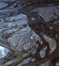
Figure 8. Aerial view of the outwash plain in the Schuchert Valley, East Greenland. The outwash plain sediments are deposited beyond the ice front by streams of meltwater. The braided pattern is characteristic of meltwater streams because sediment loads are high and water the volume varies with the amount of melting (photo by J. P. Schafer). |
Outwash plains make up most of the Cape Cod landscape. They are made up of sand and gravel deposited by meltwater streams that flowed across the plain in a braided pattern (Fig. 8).
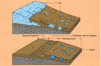
This resulted in a broad flat depositional surface that sloped gently away from the ice front. The deposits in the ice proximal part of the outwash plain were deposited atop the glacial terminus, and when the ice melted away, these (Fig. 9) deposits collapsed to form an irregular surface that sloped steeply in an up-ice direction. This slope is called an ice-contact head of outwash.
Outwash deposits also form a highly irregular and unorganized morphology called kame and kettle terrain. A kame is a knoll or hill composed of outwash deposits, which originally filled a hole in the ice.ice. When ice melted away, the deposits collapsed to form a hill. A kettle is just the opposite of a kame. The outwash was deposited around and over an ice block. When the ice block melted away, the outwash collapsed to form a hole. Figure 9 shows the relationship between buried ice and collapse morphology in kettle holes and the ice-contact head of outwash.
|
| Figure 9. Only the outwash plain that forms eastern half of the upper Cape Cod still has an ice-contact head. Ice-contact heads of outwash plains on western half of upper Cape have been incorporated into the Sandwich moraine; those of outwash plains on lower Cape have been destroyed by wave erosion. |
|
|
|
Figure 10. Cape Cod Canal is located in the drainage way of Glacial Lake Cape Cod. The water draining the lake downcut through the Sandwich moraine and flowed down the Buzzards Bay valley. |
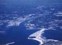
Most, if not all, of the outwash plains were formed as deltas in glacial lakes. The outwash plains on the upper Cape were formed in glacial lakes that occupied Nantucket Sound and Vineyard Sound, and those on the lower Cape were formed in a lake that occupied Cape Cod Bay. This is the best known of all the glacial lakes because outwash deltas graded to the lake occur all around Cape Cod Bay from Duxbury to Truro. Thus, the lake was given the name Glacial Lake Cape Cod. The earliest levels of the lake ranged between roughly 80 and 50 feet above present sea level, and during these lake stages, the lake drained across the Sandwich moraine and into the lowland that was to become Buzzards Bay. As the Cape Cod Bay lobe retreated northward, lower outlets were occupied and eventually the lake drained completely. The initial outlet across the Sandwich moraine was continuously lowered by erosion as the water escaped, and when the outlet was eroded to an elevation of about 30 feet, the outlet was abandoned. This low divide across the Sandwich moraine made it the obvious location for a canal connecting Cape Cod Bay and Buzzards Bay, a conclusion reached by both Miles Standish and George Washington. However, the first canal was not completed until 1914, and the improved canal (built and operated by the U.S. Army Corps of Engineers) was completed in 1940 (Fig. 10).
|
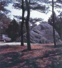
| Figure 11. Doane Rock located just off Nauset Road, Eastham is the largest glacial boulder on Cape Cod. Pits dug at the base showed as much rock below the surface as above. A boulder this large could only be deposited directly from glacial ice. |
Many other features on Cape Cod owe their existence, at least in part, to glaciation. The most common feature may be the large to very large boulders scattered about the glacial surface, usually in the moraines or ice contact terraine. These glacial boulders are too large to have been carried by running water and thus must have been deposited directly by the ice. Doane Rock in Eastham (Fig. 11)
is the largest glacial boulder known on Cape Cod, and pits dug at the base showed as much rock below the surface as above.
|
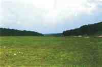
| Figure 12. Ashumet Valley in Falmouth is typical of valleys cut into outwash plains by spring sapping. The lower reaches have been drowned by sea-level rise and upper reaches are commonly the sites of cranberry bogs. |
Perhaps the most intriguing features related to glaciation are the valleys eroded in the outwash plains (Fig. 12). The valleys are relict because most do not contain rivers or streams. They are dry, except where their lower reaches have been drowned by the rise in sea level. The origin of these valleys is complex. They most likely were formed by a process called spring sapping. This occurs when the water issuing from a spring carries away loose sand and gravel and causes the spring to migrate headward carving a long straight valley. In the case of the outwash plain valleys on Cape Cod, some special conditions were required. Presently, there are few springs on Cape Cod, because in almost all places the outwash deposits are very permeable and the upper part of the outwash plain deposits is dry. In order for the spring sapping to have occurred, a higher than present water table is required. This could be accomplished by glacial lakes with altitudes well above present sea level being dammed by the outwash plains. The best example would be Glacial Lake Cape Cod that was dammed by the outwash plains and the Sandwich moraine on upper Cape Cod. The high lake levels would cause a rise in the water table that, in turn, would cause springs to form on the outwash plains. There is evidence for a glacial lake to the east of the lower Cape outwash plains in the form of the silt and clay beds exposed in the cliff below Highland Light in Truro. Nothing more is known of this lake, but it may have provided a higher than present water table to allow spring sapping to form the valleys in the lower cape outwash plains.
|
| Figure 13. Pamet River Valley in Truro is cut into the Wellfleet outwash plain and completely crosses lower Cape from Cape Cod Bay to the Atlantic and is thought to have formed when a headward eroding spring sapping valley intersected the glacial lake to east of lower Cape Cod and caused the lake to drain catastrophically. |
The Pamet Valley in Truro (Fig. 13) is wider and deeper than all other valleys on Cape Cod. The original floor of the valley, made up of glacial outwash, is well below sea level and overlain by mostly salt marsh deposits. The Pamet Valley may have started out like all other spring sapping valleys, however, the extreme width and depth of the valley requires further explanation. It is likely, that headward erosion by spring sapping cut completely across the Wellfleet outwash plain, reaching the outwash dam holding in a glacial lake to the east of the lower Cape. The breach caused the lake to drain catastrophically. This great flood carried away vast amounts of outwash to widened and deepened the original spring sapping valley.
|
|
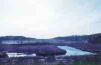
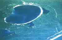
Figure 14. Great Pond in Wellfleet. This kettle pond marks the site of a large ice block left behind by the retreating South Channel lobe. The original kettle hole was far from round, but wave erosion and deposition along the shore have trimmed off headlands and closed off embayments in the shoreline much as they do along the ocean shore. |
Depressions in the outwash plain are called kettle holes. They mark the site of ice blocks that were left behind by the retreating glacier and buried by the outwash deposits. The buried ice was well insulated from the warmer post-glacial temperatures and may have persisted for several thousand years Kettle holes that are deep enough to expose the water table contain ponds or lakes
(Fig. 14). Similar to the ocean shore, waves have eroded sections along the shore to form cliffs and the eroded sand and gravel have been carried along the shore and deposited across reentrents in the shoreline. These low ridges composed of beach sand are called baymouth bars. In many kettle ponds, these processes have smoothed the shoreline so that the ponds are almost circular.
Basal organic sediments in kettle ponds have been carbon dated. The oldest ages are on the order of 12 thousand years. These early dates appear to occur in kettles that are underlain by fine sediments, which prevented or impeded the percolation of rain and snow melt. Other kettle pond basal sediments are much younger and appear to indicate the time when the rising water table, caused by the rising sea level, first intersected the floor of the kettle hole.
|
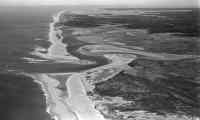
| Figure 15. Aerial photo of the embayed coastline from Nauset to Chatham. The drowned lows were formed when buried ice of sublobe of South Channel lobe melted out. Headland erosion to north of Nauset and longshore transport have formed the barriers and closed off the embayments. |
The indented coastline from Eastham southward to Chatham (Fig. 15)
also owes its existence to the Laurentide ice sheet. Most likely, it represents the last remnant of an irregular coastline made up of headlands and embayments that marked the eastern limit of the glacial Cape. It also represents a western expansion of the South Channel lobe in the form of a sublobe, which at its largest size, occupied the site of the Eastham outwash plain as well as limiting the eastern extent of the Harwich outwash plain and the distribution of the Nauset Heights deposits.
|
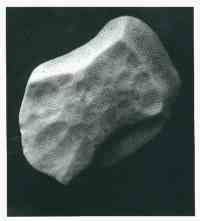
| Figure 16. Wind-polished stone or ventifact. These fluted, faceted, and pitted stones were shaped by wind driven sand, silt, and clay particles as they sat on the outwash plain surface. Later they were worked upward into the eolian layer by frost action. The unusual shape of some ventifacts cause them to be mistaken for Indian artifacts by laymen. |
At the end of glaciation and before the landscape was well covered with vegetation, winds blowing across the barren glacial deposits, including material from the exposed bottoms of drained glacial lakes, picked up sand, silt, and clay and deposited this material as a thin almost continuous blanket on the drift surface. Stones lying on the drift surface were cut, faceted, and polished by sand blasting. These stones, called ventifacts, have been moved into the windblown layer by frost action. They are distinctively shaped and some have been mistaken for tools of Indian origin (Fig. 16).
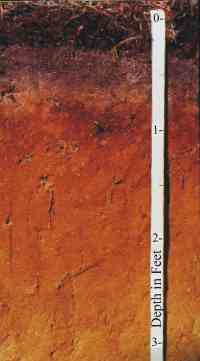
The windblown material and the upper part of the underlying drift make up the parent material for Cape Cod soils. These soils are called podzols and are typical of young soils developed on a sandy parent material in a temperate climate under forest cover. A podzol is characterized by a soil profile that consists of an upper dark organic zone and a bone-white zone that together make up the "A" horizon and a reddish orange zone that makes up the "B" horizon (Fig. 17). Beneath the "B" horizon is the parent material of the soil, either drift or the windblown layer or both.
| |
| Figure 17. A Cape Cod podzol soil. From top to bottom the soil consists of an "A" horizon made up of the organic litter zone and the leached zone (light colored zone), and the dark colored reddish orange "B" horizon. The "B" horizon is underlain by the parent material. |
|
Web Page by
Donna Newman
[an error occurred while processing this directive] |
|