
Robert I. Tilling
Christina Heliker, and
Thomas L. Wright
| ||
| Eruptions of Hawaiian Volcanoes: | ||
| Past, Present, and Future | ||
| by Robert I. Tilling Christina Heliker, and Thomas L. Wright | ||
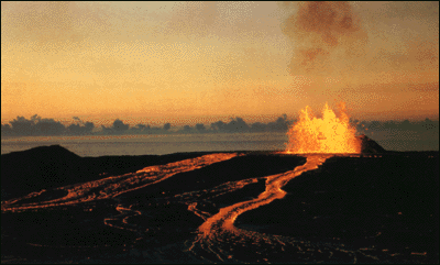
| Eruption of Kilauea Volcano, as viewed the dawn of January 30, 1974. Overflows
from an active lava lake spill down the flank of the volcanic shield at Mauna Ulu, built by many such overflows since 1969.
The height of this shield was nearly 400 feet when the Mauna Ulu eruptions ended in July 1974. (Photograph by Robert
I. Tilling.) |
|
|
| Cover photograph: Lava cascades fed by fountains at vent (skyline) fall more than 75 feet to fill Aloi Crater during the 1969-71 Mauna Ulu eruption of Kilauea Volcano. (Photograph by Donald A. Swanson.)� | First Printing, 1987. Special thanks go to Taeko Jane Takahashi and J.D. Griggs, Hawaiian Volcano Observatory, for assistance with photography selection and to Martha Kiger for graphics design. | |
Preface 4 Introduction 5 Origin of the Hawaiian Islands
7 Hawaiian Eruptions in Recorded History 13 Volcano Monitoring and Research
16
Kilauea's Volcanic "Plumbing System" 24 Eruptive Style: Powerful but Usually Benign 26
Hawaiian Volcanic Products, Landforms, and Structures 37
Loihi: Hawaii's Newest Volcano 45 Volcanic Hazards and Benefits 47
Selected Readings 52 Selected Viewings 53 Endnotes 55
|
||