
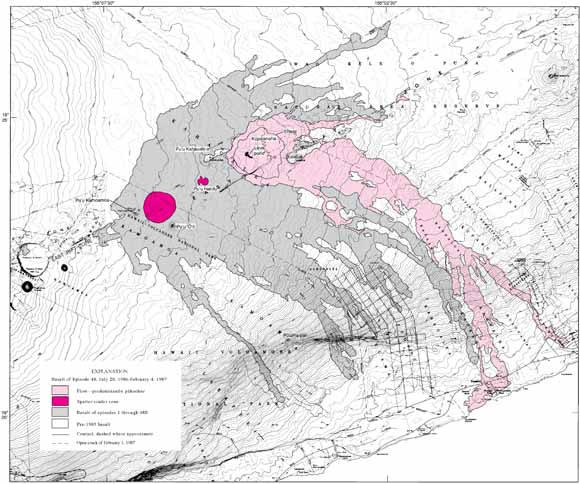
Distribution of flows, Episode 1 - early Episode 48, January 3, 1983 - February 4, 1987 (from Sheet 1)
The Puʻu ʻŌʻō - Kūpaianaha eruption on the middle east rift zone of Kīlauea began in January 1983 with intermittent activity along several fissures. By June 1983, the eruption had localized at the Puʻu ʻŌʻō vent, and the activity settled into an increasingly regular pattern of brief eruptive episodes characterized by high lava fountains. The first 18 months of this eruption are chronicled in Wolfe and others (1988), which includes maps of the flows erupted in episodes 1-20. The maps presented here extend this series through the beginning of episode 48. |
| File
Name |
File
Type and Description |
File
Size |
| | ||
| FILES for VIEWING and PLOTTING |
||
| Six maps, text, and table (PDF file of ~51" x 34" sheet):
•Distribution of flows, Episode 1 - early Episode 48, January 3, 1983 - February 4, 1987 •Eruptive fissures, January 3, 1983 - February 1987 •Episode 21 •Episode 22 •Episode 23 •Episode 24 |
2.6 MB |
|
| Eight maps (PDF file of ~56" x 33" sheet):
•Episode 25 •Episode 26 •Episode 27 •Episode 28 •Episode 29 •Episode 30 •Episode 31 •Episode 32 |
1.7 MB |
|
| Eight maps (PDF file of ~56" x 33" sheet):
•Episode 33 •Episode 34 •Episode 35 •Episode 36 •Episode 37 •Episode 38 •Episode 39 •Episode 40 |
1.6 MB |
|
| Eight maps (PDF file of ~56" x 33" sheet):
•Episode 41 •Episode 42 •Episode 43 •Episode 44 •Episode 45 •Episode 46 •Episode 47 •Episode 48 through August 3, 1986 |
1.6 MB |
|
For questions about the content of this report, contact Christina Heliker
Download a current version of Acrobat Reader for free
| Help
| PDF help
| Publications main page | Western reports main page |
| Western Geologic and Miscellaneous Investigation Series Maps |
| Privacy
Statement | Disclaimer
| Accessibility |
| Geologic
Division | Volcano Hazards Program
|
This map is also available in print from:
USGS Information Services, Box 25286,
Federal Center, Denver, CO 80225
telephone: 303-202-4210; e-mail: [email protected]