|
Sidescan-Sonar Imagery of the Shoreface and Inner Continental Shelf, Wrightsville Beach, North Carolina
|
Study Area
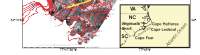
Wrightsville Beach is a low, transgressive barrier island in southeastern North Carolina (Figure 1, at right). It is located in the southern portion of Onslow Bay, a broad, shallow, relatively high-energy shelf environment between Cape Lookout and Cape Fear (see Figure 1, inset). This portion of the North Carolina coast is lined by both transgressive and regressive barrier islands (Nummedal 1983) backed by narrow, marsh-filled lagoons.
Onslow Bay is a microtidal environment, with a mean tidal range of about 1 meter (m). The dominant direction of wave approach is from the northeast during the winter months, and from the southeast during the summer Typically, storm waves approach from the northeast, but the area is also subject to episodic storm wave events from the east and south during the passage of tropical and extra tropical cyclones. Hindcast wave data (WIS studies) indicate a mean wave height of 1.1 meters, with a
7 second period. The dominant direction of wave approach is from the southeast. Based on four years of wave gage data obtained at Wrightsville Beach during 1971-1975, Jarrett (1977) found a mean significant wave height of 0.78 m, with a
corresponding period of 7.88 seconds. The net longshore drift is to the southwest.
The Onslow Bay shelf is sediment-starved (Cleary and Pilkey 1968; Riggs and others 1996). The introduction of new sediment to Onslow Bay is negligible due to: 1) no fluvial input (coarse sediments are trapped in the upper estuarine system); and 2) minimal sediment exchange between adjacent shelf embayments (Blackwelder and others 1982). Milliman and others (1972) classified the Onslow Bay shelf sediment cover as residual (derive from the erosion of underlying sediments and rocks). The modern, native sediments on the Wrightsville Beach shoreface and inner shelf are derived from shoreface bypassing of unconsolidated, ancient sediments and the physical- and bio-erosion of marine hardbottoms (exposed rock outcrops).
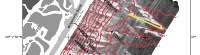
Wrightsville Beach is one of the four most-nourished beaches (i.e. large, federally-funded nourishment projects) on the U.S. East Coast (Pilkey and Clayton 1987; 1989). Major nourishments have been carried out at approximately four-year intervals since 1965, each of which involved the placement of approximately 1x10⁶ m3 of material dredged from the backbarrier lagoon (Figure 1, Banks Channel) and portions of Masonboro Inlet (Figure 1). The nourishment sediment constitutes another source of modern sediment in this coastal system (Pearson and Riggs 1981; Thieler and others 1994).
 |
Based on E. Robert Thieler, William C. Schwab, Mead A.
Allison, Jane F. Denny, and William W. Danforth, Sidescan-Sonar Imagery of the
Shoreface and Inner Continental Shelf, Wrightsville Beach, North Carolina: U.S. Geological Survey Open-file Report OF 98-616.
|
Web page: Donna
Newman
[an error occurred while processing this directive]
|
|