|
Sidescan-Sonar Imagery of the Shoreface and Inner Continental Shelf, Wrightsville Beach, North Carolina
|
Previous Work
 |
|
Using sidescan-sonar imagery, bathymetric data and sediment samples, Thieler and others (1994; 1995) found that the morphology of the Wrightsville Beach shoreface and inner shelf is dominated by linear, shore-perpendicular rippled scour depressions (sea-floor depressions floored with rippled, coarse shell hash and gravel [RSDs] ). They speculated that the RSDs serve as conduits for cross-shore sediment flux between the beach and the shelf, and that the underlying geologic framework controls the distribution and morphology of these features.
Snyder and others (1994) mapped the regional seismic stratigraphic framework of the inner continental shelf of southern Onslow Bay, including the Wrightsville Beach area. The inner shelf surface consists of an unconsolidated, early Oligocene sandy silt (designated Orb-A and proposed by Snyder and others (1994) to be equivalent to the River Bend Formation), which has been dissected by Quaternary and Plio-Pleistocene fluvial channels. Detailed seismic reflection and vibracore data from the Wrightsville Beach area (Thieler,1997) confirmed the regional stratigraphic framework proposed by Snyder and others(1994). However, the dense nature of the geophysical data used by Thieler (1997), coupled with its higher resolution and the extensive groundtruth furnished by the vibracore data, permitted the identification of additional lithosomes and the construction of a more tightly controlled stratigraphic framework than that proposed by Snyder and others (1994).
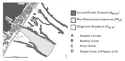
Figure 2 (see figure above) shows the distribution of Quaternary paleo-fluvial channel-fill (QPFCF) and Plio-Pleistocene valley-fill (PPvf) lithosomes in the study area. The QPFCF lithosomes cut 10-20 meters into the Oligocene section (Snyder and others 1994; Thieler 1997). The seismic architecture of the Quaternary fluvial systems indicates they have undergone multiple cycles of cut and fill, as they were occupied repeatedly during the Quaternary (Snyder and others 1994; Thieler 1997). The distribution of QPFCF lithosomes also exhibits a strong correlation with the present subaerial drainage pattern; Figure 2 indicates major incised channel systems and their probable linkage to existing tidal creeks. The uppermost sections of the QPFCF units retain, in places, a record of the Holocene transgression that is mappable in the subsurface and is exposed on the sea floor (Thieler 1997).
The PPvf lithosomes probably represent the deeper preserved thalwegs of former fluvial systems that were excavated and backfilled during multiple sea-level oscillations in the late Tertiary and Pleistocene (Snyder and others, 1994). Vibracores penetrating the PPvf lithosomes contain a variety of limestone litholgies, ranging from fine sand to bioclastic gravel, and exhibit wide variations in induration. Onshore water-well logs and ground-penetrating radar surveys (Thieler 1997) on Wrightsville Beach have identified the landward extension of the southern PPvf lithosome shown in Figure 2.
 |
Based on E. Robert Thieler, William C. Schwab, Mead A.
Allison, Jane F. Denny, and William W. Danforth, Sidescan-Sonar Imagery of the
Shoreface and Inner Continental Shelf, Wrightsville Beach, North Carolina: U.S. Geological Survey Open-file Report OF 98-616.
|
Web page: Donna
Newman
[an error occurred while processing this directive]
|
|