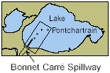
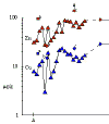
The Bonnet Carré Spillway is a site of former large crevasses that was converted into a spillway designed to protect New Orleans from floodwaters of the Mississippi River. It was constructed by the U.S. Army Corps of Engineers in 1931. During a controlled opening for 2 ½ months in 1978, the in-flowing waters deposited a large lobe of silty sand an average of 19 cm thick in proximity to the spillway mouth. Oyster fishermen have noticed that when the spillway brought freshwater into Lake Pontchartrain, the reduction in salt resulted in increased oyster production in estuarine areas outside the Rigolets inlet. Fresher waters reduced the effect of the parasitic oyster drill. This beneficial result for oyster harvests increased pressure for controlled openings of the Spillway in the absence of flood risk. But such freshwater input created environmental changes that drew criticisms from local fishermen and environmental organizations (see topical abstracts in the Basics of the Basin Symposium Series, Lopez, this publication). A major algal bloom followed after the opening of the Spillway in response to flood states of the Mississippi River in 1997. The bloom created anoxic bottom conditions deleterious to benthic organisms and shrimp and triggered renewed debate about the direct and indirect costs and effects of Spillway policy. Figure 26 shows profiles of zinc and copper concentrations and sample distribution in the vicinity of the Bonnet Carré Spillway. The lower metal concentrations at locations very close to shore are attributable to dilution of finer-grained (metal-enriched mineral fractions) with metal-poor sand.
More sensitive assessment of the presence of inorganic contaminants to lake sediments
will be possible by comparison of data from surficial sediments with dated core profiles
(M. Marot and C.W. Holmes, in progress). Deeper core samples will enable comparison of
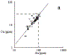
metal Data of earlier authors (e.g. Overton and others, 1984; Schurtz and St. Pe, 1984)
showed a sharp increase in surface-sediment metals as well as organic contaminants on
approach to the New Orleans shoreline, especially a few hundred meters distance from
canals (Overton and others, 1986). The metal plots in the Inorganics
Section demonstrate that virtually all samples with significantly elevated
concentrations are located in the vicinity of the New Orleans coast or other urban areas
(Slidell).
|
||||||||||||||||