
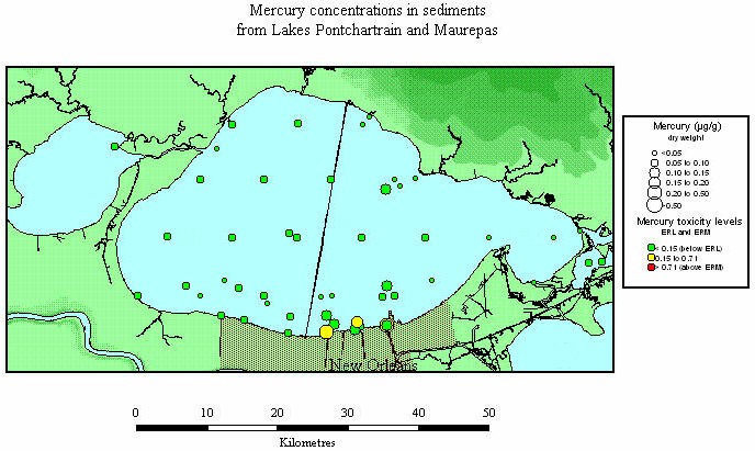
III. Data and Preliminary Interpretations (con't)F. Coastal and Inland Waterway Impacts and Sediment Toxicity ConsiderationsAs noted in previous sections (Inorganics, Organic, Bonnet Carré), data show high metal and organic contaminants near the New Orleans shoreline, especially within 1 kilometer of canals (Overton and others, 1986). The metal plots in Section C demonstrate that virtually all quality-controlled samples with significantly elevated concentrations are located in the vicinity of the New Orleans coast or other urban areas (such as Slidell). A few isolated Hg values in more centrally-located areas in Lake Pontchartrain and Maurepas shown in Figure 22 have not been corroborated by subsequently-entered, high-quality EMAP (1998) data. Inland Waterways Noteworthy are the high metal concentrations in Bayou Trepagnier, a small inland water
body adjacent to Bonnet Carré Spillway (see opening illustration
for location of Spillway; Figures 17, 19, 21 for metal
concentrations). Neither the few samples within the Spillway nor the many outside but in
proximity to shore show contaminant enrichment. Therefore, the severe contamination due to
waste discharge from a petrochemical plant (LDEQ, 1989) was restricted mainly to Bayou
Trepagnier proper and decreased sharply with distance from the plant. Subsequent to the
main investigations of water in this inland water body, flow was redirected to discharge
into the Mississippi River. Toxicity guidelines Figure 28 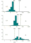 Recent guidelines relating chemical composition of bulk sediment
to effects-based toxicity criteria provide a screening-level assessment of the
environmental status of sediments with respect to specific contaminants. These are
illustrated in histograms for three of the heavy metals in Figure
28. The dashed lines refer to effects-based animal toxicity criteria of Long and
others (1995). The data on which the threshold values are based were gained from a
nation-wide set of data that include both laboratory toxicity tests on sensitive
organisms, and contaminant analyses on bulk sediment samples (dry weight basis). The
"ERM" values are defined at concentration ranges associated with a 50 percentile
level of acute toxicity symptoms in test organisms. The "ERL" level corresponds
to the 10 percentile level.(see Appendix B). Since this type of
toxicity criterion is statistically based on national samplings, it can only suggest
toxicity potential in relative terms to specific local samples or areas. Nor can it assess
bioaccumulation and other more specific issues for given species. However, the ERL and ERM
guidelines have gained wide use as a conservative screening tool that is particularly
useful to identify areas that should be subjected to more detailed analysis
("higher-tier" toxicity testing). This type of criterion is the only one
applicable to historical sediments. Alternative approaches are summarized in Baker and
Kravitz (1992). Recent guidelines relating chemical composition of bulk sediment
to effects-based toxicity criteria provide a screening-level assessment of the
environmental status of sediments with respect to specific contaminants. These are
illustrated in histograms for three of the heavy metals in Figure
28. The dashed lines refer to effects-based animal toxicity criteria of Long and
others (1995). The data on which the threshold values are based were gained from a
nation-wide set of data that include both laboratory toxicity tests on sensitive
organisms, and contaminant analyses on bulk sediment samples (dry weight basis). The
"ERM" values are defined at concentration ranges associated with a 50 percentile
level of acute toxicity symptoms in test organisms. The "ERL" level corresponds
to the 10 percentile level.(see Appendix B). Since this type of
toxicity criterion is statistically based on national samplings, it can only suggest
toxicity potential in relative terms to specific local samples or areas. Nor can it assess
bioaccumulation and other more specific issues for given species. However, the ERL and ERM
guidelines have gained wide use as a conservative screening tool that is particularly
useful to identify areas that should be subjected to more detailed analysis
("higher-tier" toxicity testing). This type of criterion is the only one
applicable to historical sediments. Alternative approaches are summarized in Baker and
Kravitz (1992).
|
|||||||