 INTRODUCTION
To choose other pages, return to the home page.
by David A. Lindsey
INTRODUCTIONMineral deposits at Spor Mountain, in the Thomas Range of western Utah, are well-known examples of the association of fluorine with lithophile metal mineralization in a volcanic environment. In addition to fluorspar, the Spor Mountain district contains the world's largest economic deposits of beryllium and has produced uranium in the past. This slide show summarizes the geologic setting and history of volcanism and mineralization at Spor Mountain, discusses major controls of mineralization, and describes processes of mineralization and alteration that may have formed the mineral deposits at Spor Mountain. The discovery and economic significance of the Spor Mountain beryllium deposits is discussed by Griffitts (1964) and Williams (1963). Mining methods are discussed by Davis (1984).
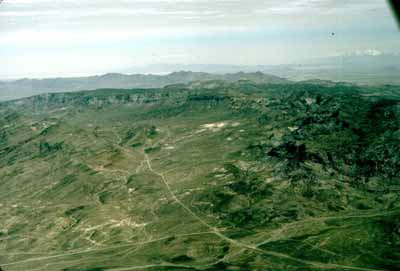
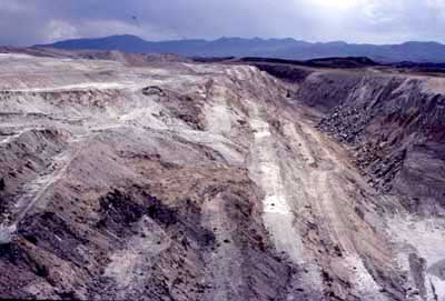
SLIDE 1 (above or left) is an aerial view looking north at the eastern part of (from left to right) Spor Mountain, The Dell, and most of the Thomas Range in 1978. The excavations in the left foreground, within the southernmost part of Spor Mountain, include the Bell Hill fluorspar mine. The Yellow Chief open pit uranium mine is visible in the center of the photo. The cliffs beyond are flows of Topaz Mountain Rhyolite of Miocene age. Beyond the cliffs is the Dugway Range. The principal area of beryllium mining is out of view, to the lower left of the photo. More aerial views (SLIDES 2-9) includes photos of beryllium mines.
 LOCATION
AND REGIONAL SETTING
LOCATION
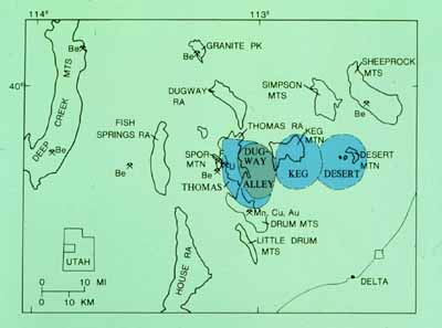
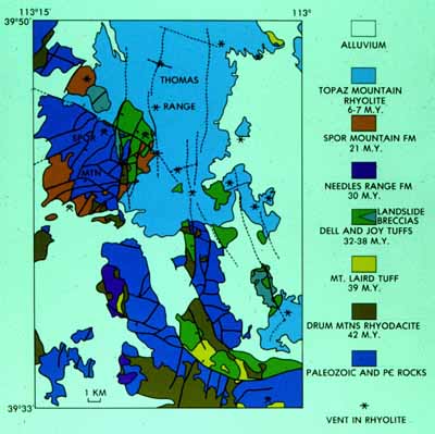
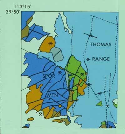
AND REGIONAL SETTINGSLIDE 10 (left) shows the location of Spor Mountain, other ranges, and beryllium occurrences in western Utah. The center of mineralization was at Spor Mountain, situated along the ring fracture of the Thomas caldera, on the west side of the Thomas Range. The Thomas caldera was one of at least three volcanic subsidence structures formed during Oligocene time in an east-west trending belt of Tertiary age igneous rocks and mineral deposits, called the "beryllium belt of western Utah," also the "Deep Creek-Tintic belt." In addition to fluorspar, beryllium, and uranium at Spor Mountain, the belt contains other beryllium occurrences and deposits or occurrences of copper, base metals, and gold scattered between the Deep Creek Mountains on the west and the East Tintic Mountains (not shown) on the east. Pronounced aeromagnetic anomalies, in part reflecting igneous stocks and thick accumulations of volcanic rocks in calderas, accompany the mineral belt. The regional setting of the belt is described by Cohenour (1963), Hilpert and Roberts (1964), and Shawe (1972).
The map in slide 10 shows three calderas (in blue) identified by Shawe (1972) and a fourth (shown in dark green) hypothesized by Lindsey (1982), as well as locations of some beryllium occurrences in the Deep Creek-Tintic belt.
 FLUORSPAR: Spor Mountain was first mined in
1943 for fluorspar; most mines are in carbonate rock formations
on Spor Mountain. Mines are typically small adits, shafts, and
irregular workings that follow pipe-like ore bodies and veins.
Most pipes are mineralized breccias located along faults or fault
intersections. Some contain rhyolite and are evidently plugs or
volcanic vents. The geology of the fluorspar deposits is described
by Staatz and Osterwald (1959) and Staatz and Carr (1964).
FLUORSPAR: Spor Mountain was first mined in
1943 for fluorspar; most mines are in carbonate rock formations
on Spor Mountain. Mines are typically small adits, shafts, and
irregular workings that follow pipe-like ore bodies and veins.
Most pipes are mineralized breccias located along faults or fault
intersections. Some contain rhyolite and are evidently plugs or
volcanic vents. The geology of the fluorspar deposits is described
by Staatz and Osterwald (1959) and Staatz and Carr (1964).
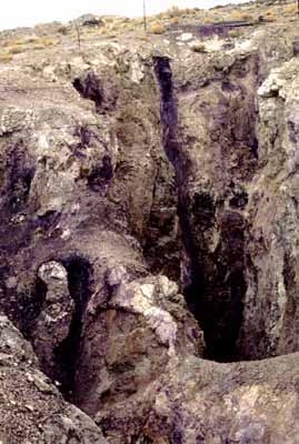
SLIDE 11 (left) shows surface workings at the Bell Hill mine in 1979. The view is to the west. In the photo, fluorspar occurs in breccia pipes that join below; fluorspar veins like the prominent one in the center of the photo, as much as 2 ft across, cut across the pipes.
URANIUM: Uranium in trace amounts is widespread in the Spor Mountain district, but uranium was mined in commercial amounts only at the Yellow Chief mine, located in The Dell, east of Spor Mountain. Tabular lenses of ore were mined until 1962 by open pit. Ore occurs in tuffaceous sandstone that has been correlated with the tuff that hosts beryllium deposits nearby. The geology of the Yellow Chief mine was first discussed by Bowyer (1963) and Staatz and Carr (1964) and was revised by Lindsey (1978) after remapping.
SLIDE 12 (above) of the Yellow Chief pit was taken in 1976, about 14 years after mining ceased. The view of the north face shows bentonite (white) overlying tuffaceous sandstone with two lenses of uranium ore, located by the arrows. Beds in the pit dip west.
 BERYLLIUM: Beryllium
at Spor Mountain has been mined by Brush Wellman since about 1970
and remains the major commercial resource of this metal in the
United States. Ore is mined from linear open pits that follow
the strike of the tilted ore-bearing tuff. Deposits are mined
to shallow depths (very approximately, 30-50 m). Depth is limited
by the cost of stripping hard rhyolite caprock. Most published
information on the Spor Mountain beryllium ore comes from the
deposit at the Roadside mine. Descriptions of the deposits at
various stages of development have been given by Staatz and Griffitts
(1961), Williams (1963), Griffitts (1964), Shawe (1968), and Lindsey
and others (1973).
BERYLLIUM: Beryllium
at Spor Mountain has been mined by Brush Wellman since about 1970
and remains the major commercial resource of this metal in the
United States. Ore is mined from linear open pits that follow
the strike of the tilted ore-bearing tuff. Deposits are mined
to shallow depths (very approximately, 30-50 m). Depth is limited
by the cost of stripping hard rhyolite caprock. Most published
information on the Spor Mountain beryllium ore comes from the
deposit at the Roadside mine. Descriptions of the deposits at
various stages of development have been given by Staatz and Griffitts
(1961), Williams (1963), Griffitts (1964), Shawe (1968), and Lindsey
and others (1973).
SLIDE 13 (left) of the Roadside pit, was taken in 1970. The view is to the south, with the Fish Springs Range in the background. The picture shows a pit face of rhyolite caprock on the right; the caprock has been stripped to expose ore in the bottom of the pit, in the upper part of the beryllium tuff.
Other mines and prospects (SLIDES 14-15) are located around the periphery of Spor Mountain, on the east side of Fish Springs Flat and in The Dell (see "Location and regional setting," above).
 HISTORY OF VOLCANISM AND MINERALIZATION
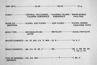
Igneous rocks and mineral deposits of the beryllium belt formed during three stages of volcanism: 1) rhyodacitic and quartz latitic eruption of flows, breccias, and tuffs, ending in initial eruption of ashflow tuff and caldera collapse, 2) rhyolitic to quartz latitic ashflow tuff eruption and continued cauldron subsidence, and 3) post-caldera eruption of rhyolite and basalt flows and domes. Each stage is characterized by distinctive compositions of igneous rocks, mode of volcanic eruption, tectonic structures, and types of ore deposits formed. The most recent discussion of geologic history is by Lindsey (1982). Detailed geologic maps are by Staatz and Carr (1964) and Lindsey (1979).
SLIDE 16 (table above or left) summarizes the geologic history of volcanism and mineralization in the Deep Creek-Tintic belt. SLIDE 17 (geologic map below) shows rocks and structures of the Thomas Range and northern Dugway Range. Both the table and map were prepared in 1980. The unit identified on the map as Oligocene "Needles Range Formation" has since been determined to be of local origin, and is no longer considered to correlate with the Needles Range.
 The first stage of volcanism
was characterized by eruption of flows, breccias and tuffs of
rhyodacite (SLIDE 18) to quartz latitic
composition about 42-39 Ma (million years ago). Early volcanism
culminated with eruption of the Eocene Mt.
Laird Tuff (SLIDE 19) from the southwestern part of the Thomas
caldera, about 39 Ma. The Mt. Laird eruption initiated subsidence
of the Thomas caldera. The west side of the caldera is marked
by a topographic wall and scarp of the Joy
fault (SLIDE 20), which extends northward past the east side
of Spor Mountain. The caldera margin is also marked by the confinement
of younger, thick intracaldera ashflow tuff east of the Joy fault,
and by caldera-wall landslide deposits
(SLIDES 21-22) at Spor Mountain. A center of igneous intrusion,
explosive eruption of breccia pipes, and copper, manganese and
gold mineralization developed in the Drum Mountains, immediately
south of the caldera margin (Nutt and others, 1991).
The first stage of volcanism
was characterized by eruption of flows, breccias and tuffs of
rhyodacite (SLIDE 18) to quartz latitic
composition about 42-39 Ma (million years ago). Early volcanism
culminated with eruption of the Eocene Mt.
Laird Tuff (SLIDE 19) from the southwestern part of the Thomas
caldera, about 39 Ma. The Mt. Laird eruption initiated subsidence
of the Thomas caldera. The west side of the caldera is marked
by a topographic wall and scarp of the Joy
fault (SLIDE 20), which extends northward past the east side
of Spor Mountain. The caldera margin is also marked by the confinement
of younger, thick intracaldera ashflow tuff east of the Joy fault,
and by caldera-wall landslide deposits
(SLIDES 21-22) at Spor Mountain. A center of igneous intrusion,
explosive eruption of breccia pipes, and copper, manganese and
gold mineralization developed in the Drum Mountains, immediately
south of the caldera margin (Nutt and others, 1991).
The second stage of volcanism was characterized by eruption of rhyolitic ashflows at 38 and 32 Ma. These tuffs (Oligocene and Eocene Joy Tuff (SLIDES 23-25) and Oligocene Dell Tuff) largely filled the Thomas and adjacent calderas as subsidence continued. The source of some of the tuff is believed to be a cauldron beneath Dugway Valley. Possible vent breccias crop out in the southeastern part of the Thomas Range. Landslide megabreccia on tuff in the northern Drum Mountains may mark the west side of the Dugway Valley cauldron. Mineralization during the second stage was sparse or absent.
The third stage of volcanism began at 21 Ma with eruption of the Miocene Spor Mountain Formation. The first eruptions deposited the stratified beryllium tuff member and formed a complex of rhyolite domes, flows and plugs (the porphyritic rhyolite member) in the vicinity of Spor Mountain. Between 21 and 7 Ma, the Spor Mountain Formation and all older formations were cut and tilted by basin-range faulting. All of western Utah was broken into basin-range fault blocks of varying sizes. At Spor Mountain, deposits of fluorspar, beryllium, and uranium were formed during and after eruption of the Spor Mountain Formation. At 6-8 Ma, extensive tuffs, flows and domes of Miocene Topaz Mountain Rhyolite (SLIDES 26-34) were erupted in the Thomas Range and the Keg Mountain area (SLIDES 35-40), located east of the Thomas Range. Only weak mineralization accompanied eruption of the Topaz Mountain Rhyolite, and no mineralization at all is known from the Keg Mountains. Basaltic rocks, also characteristic of the third stage of volcanism, are not represented in the vicinity of Spor Mountain, but were erupted at Fumarole Butte (SLIDE 41), located about 20 miles southeast of Spor Mountain. A small analog of the mineralized rhyolite at Spor Mountain is found at the Honeycomb Hills (SLIDES 42-45), located about 20 miles west of Spor Mountain.
Controls of mineralization are defined by 1) magma chemistry, 2) favorable host rocks, and 3) structure. The association of fluorine and lithophile metals (primarily, Be, Li, U) mineralization with alkali rhyolite volcanism and basin-range extensional faulting indicates that extensional tectonism may be a fundamental cause of mineralization. In addition to this general control, both stratigraphic and structural features provided paths for mineralizing fluids. Controls of mineralization are summarized by Lindsey (1977) and updated by Lindsey (1982).
 MAGMA
CHEMISTRY: The three stages of volcanism are marked by distinct
chemical compositions of major oxides and trace elements. Rocks
of the first stage, of rhyodacitic and quartz latitic composition,
contain the largest trace concentrations of base metals such as
lead, zinc, and copper. Rocks of the middle stage, mostly rhyolite,
contain the smallest concentrations of all trace elements. Alkali
rhyolite of the third, post-caldera stage, contains the largest
trace concentrations of lithophile elements such as beryllium,
lithium, thorium, and uranium. Trace element concentrations of
these rocks are interpreted as primary, indicative of retention
in erupted magma. Mineralizing fluids either interacted directly
with fluorine and lithophile-rich magma or secondarily by leaching
eruptive products. Low content of trace elements, especially lithophile
elements, in caldera-forming rhyolite tuffs may reflect volatilization
and eruption into the atmosphere.
MAGMA
CHEMISTRY: The three stages of volcanism are marked by distinct
chemical compositions of major oxides and trace elements. Rocks
of the first stage, of rhyodacitic and quartz latitic composition,
contain the largest trace concentrations of base metals such as
lead, zinc, and copper. Rocks of the middle stage, mostly rhyolite,
contain the smallest concentrations of all trace elements. Alkali
rhyolite of the third, post-caldera stage, contains the largest
trace concentrations of lithophile elements such as beryllium,
lithium, thorium, and uranium. Trace element concentrations of
these rocks are interpreted as primary, indicative of retention
in erupted magma. Mineralizing fluids either interacted directly
with fluorine and lithophile-rich magma or secondarily by leaching
eruptive products. Low content of trace elements, especially lithophile
elements, in caldera-forming rhyolite tuffs may reflect volatilization
and eruption into the atmosphere.
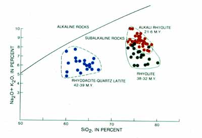
SLIDE 46 (above or right) is a total alkali-silica diagram of volcanic rocks in the Thomas Range and northern Drum Mountains. It illustrates the compositional differences among the three stages of volcanism. Plots of trace element content are given by Lindsey (1982).
 FAVORABLE HOST ROCK:
The host-rock control of beryllium and uranium deposits at Spor
Mountain is precise: every important deposit of beryllium and
the only economic deposit of uranium occur in the beryllium tuff
member of the Spor Mountain Formation. Beryllium is mined from
the top of the beryllium tuff member, immediately beneath the
mostly unmineralized porphyritic rhyolite member. The beryllium
tuff is a favorable host for beryllium ore because 1) it is adjacent
to faults and rhyolite vents where mineralizing fluids could enter
the tuff, 2) it is a porous, reactive conduit for mineralizing
fluids, including both hydrothermal and ground waters, and 3)
it contains carbonate clasts, which reacted with fluorine-rich
fluids to precipitate fluorite and beryllium.
FAVORABLE HOST ROCK:
The host-rock control of beryllium and uranium deposits at Spor
Mountain is precise: every important deposit of beryllium and
the only economic deposit of uranium occur in the beryllium tuff
member of the Spor Mountain Formation. Beryllium is mined from
the top of the beryllium tuff member, immediately beneath the
mostly unmineralized porphyritic rhyolite member. The beryllium
tuff is a favorable host for beryllium ore because 1) it is adjacent
to faults and rhyolite vents where mineralizing fluids could enter
the tuff, 2) it is a porous, reactive conduit for mineralizing
fluids, including both hydrothermal and ground waters, and 3)
it contains carbonate clasts, which reacted with fluorine-rich
fluids to precipitate fluorite and beryllium.
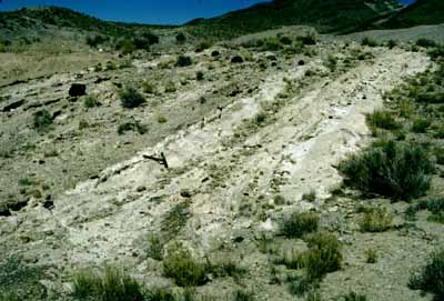
SLIDE 47 (above or right) shows one of the few natural outcrops of the beryllium tuff remaining in 1969, south of Spor Mountain. Other natural exposures are found in The Dell. The few natural outcrops may be atypical in that they do not contain abundant clasts of carbonate rock. Tuff with carbonate clasts (SLIDES 48-49) is well-exposed in mines and prospect pits on the southwest side of Spor Mountain. Carbonate-clast tuff was formed by explosive eruption of the Spor Mountain Rhyolite through carbonate rocks of Paleozoic age.
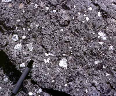
 SLIDE 50 (left)
shows the porous, reactive beryllium tuff, initially composed
of volcanic glass, zeolite, and abundant fragments of carbonate
rock. The specimen contains abundant angular fragments of carbonate
rock in tuff from the Monitor pit. The specimen represents the
first stage of alteration of dolomite fragments to calcite. The
matrix is still glassy.
SLIDE 50 (left)
shows the porous, reactive beryllium tuff, initially composed
of volcanic glass, zeolite, and abundant fragments of carbonate
rock. The specimen contains abundant angular fragments of carbonate
rock in tuff from the Monitor pit. The specimen represents the
first stage of alteration of dolomite fragments to calcite. The
matrix is still glassy.
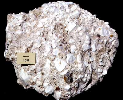
 SLIDE 51 (right)
shows the beryllium tuff after mineralization. Mineralized tuff
is composed of a matrix of clay and potassium feldspar and the
dolomite fragments have been replaced by fluorite, clay, chalcedonic
quartz, and manganese oxide. The specimen is mineralized tuff
from the Roadside pit. Mineralized tuff specimens
(SLIDES 52-54) contain a variety of nodules formed by replacement
of rock fragments.
SLIDE 51 (right)
shows the beryllium tuff after mineralization. Mineralized tuff
is composed of a matrix of clay and potassium feldspar and the
dolomite fragments have been replaced by fluorite, clay, chalcedonic
quartz, and manganese oxide. The specimen is mineralized tuff
from the Roadside pit. Mineralized tuff specimens
(SLIDES 52-54) contain a variety of nodules formed by replacement
of rock fragments.
STRUCTURE: SLIDE 55 (left) shows some details of the structural geology of Spor Mountain (see slide 18 for explanation of colors and symbols). Both eruption of alkali rhyolite and the flow of mineralizing fluids were influenced by basin-range faults. Vents (shown by asterisks on the map) for the Spor Mountain Formation (and the younger Topaz Mountain Rhyolite) were located along faults and fault intersections. On Spor Mountain and in The Dell, rhyolite plugs and domes mark vents for the Spor Mountain Formation. A small dome, located at a fault intersection on the south slope of Spor Mountain, contains a fringe of mineralized pumiceous rhyolite and tuff.
Fluorspar pipes on Spor Mountain also occur along faults and at fault intersections, indicating that they, too, are fault-controlled.
Some faults existed prior to eruption of rhyolite, but displacement of Spor Mountain Formation and, locally, even the younger Topaz Mountain Rhyolite, indicates repeated basin-range faulting. The fault system that separates Spor Mountain from The Dell follows the margin of the Thomas caldera; it was reactivated during basin-range faulting. At the Claybank beryllium prospect and the Bell Hill fluorspar mine, breccia and wallrock in the reactivated margin fault were mineralized.
Fluorspar, beryllium, and uranium ore differ markedly in occurrence, mineral association, and alternation minerals. Fluorspar is described in detail by Staatz and Osterwald (1959) and Staatz and Carr (1964); uranium ore, by Bowyer (1963) and Staatz and Carr (1964); and beryllium ore, by Staatz and Griffitts (1961), Griffitts and Rader (1963), Shawe (1968), and Lindsey and others (1973). Only beryllium and uranium ore are discussed here.
SLIDE 56 (below) shows the distribution of alteration minerals and beryllium in a section through the Roadside beryllium ore body.
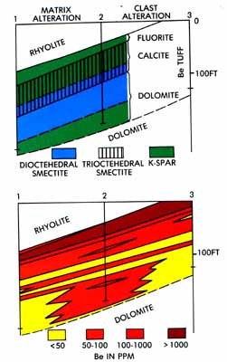 BERYLLIUM: At most places, beryllium ore is
concentrated in the upper part of the beryllium tuff member, as
typified by the Roadside ore body. Feldspathic and montmorillonitic
(smectite) clay alteration zones, including lithium-bearing trioctahedral
smectite, closely follow and enclose beryllium ore (>1,000
ppm Be). In ore, carbonate clasts have been largely replaced by
fluorite that contains submicroscopic bertrandite. Below ore,
clasts that have been altered to calcite persist downward and
are accompanied by anomalous amounts of lithium (probably in associated
smectite). In the lowest part of the beryllium tuff, unmineralized
dolomite clasts predominate.
BERYLLIUM: At most places, beryllium ore is
concentrated in the upper part of the beryllium tuff member, as
typified by the Roadside ore body. Feldspathic and montmorillonitic
(smectite) clay alteration zones, including lithium-bearing trioctahedral
smectite, closely follow and enclose beryllium ore (>1,000
ppm Be). In ore, carbonate clasts have been largely replaced by
fluorite that contains submicroscopic bertrandite. Below ore,
clasts that have been altered to calcite persist downward and
are accompanied by anomalous amounts of lithium (probably in associated
smectite). In the lowest part of the beryllium tuff, unmineralized
dolomite clasts predominate.
Mineralized nodules (commonly called "beryllium nodules," SLIDES 57-62) are locally abundant in beryllium ore; they represent altered clasts of carbonate rock. Other clasts, of quartzite, limestone, and volcanic rocks, are little altered. Carbonate clasts show the alteration sequence dolomite-calcite-chalcedonic quartz/opal-fluorite.
Matrix of mineralized tuff consists of smectite (both dioctahedral and trioctahedral varieties), opal, potassium feldspar, and minor kaolinite. Glassy and zeolitic tuff was probably altered in the sequence smectite-sericite-potassium feldspar. Beryllium (bertrandite)-bearing matrix is clay-rich but commonly also feldspathic. Feldspathic alteration is best detected by X-ray diffraction and by overgrowths of clear potassium feldspar on volcaniclastic crystals. Photomicrographs (SLIDES 63-65) show typical matrix of glass and alteration products.
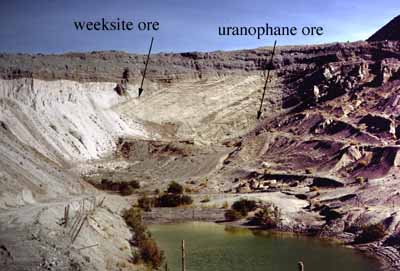
Mineralized tuff also contains pore fillings and veinlets of opal (SLIDE 66), manganese oxide minerals, and yellow secondary uranium minerals, including weeksite (SLIDE 67) and beta-uranophane.
URANIUM: Anomalous amounts of uranium are broadly associated with beryllium ore but, at the Roadside ore body, the principal uranium anomaly (100-200 ppm) underlies beryllium ore. The major thorium anomaly (100-150 ppm), in contrast to uranium, follows beryllium ore. Below the beryllium ore, thorium levels decline to crustal background values. The ratio of thorium to uranium (>4) rises to crustal background.
The cross-section in slide 56 shows the distribution of alteration minerals and beryllium values in cuttings from three exploration drillholes in the Roadside ore body. These sections are discussed in detail by Lindsey (1977, 1982). Uranium and thorium (SLIDES 68-69) distribution is shown in additional cross sections.
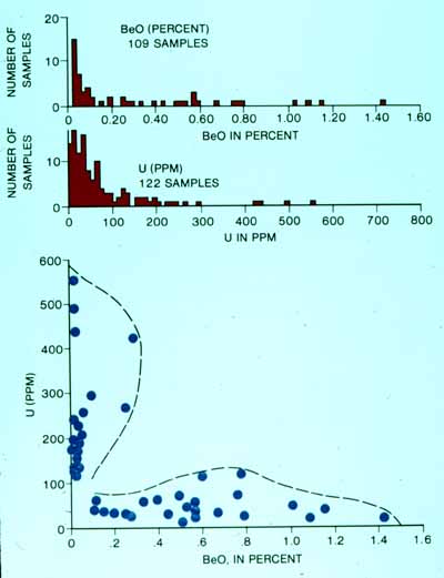 SLIDE 70 (left)
summarizes analyses of drill cuttings from many mineralized zones
in the beryllium tuff member. Anomalous levels of beryllium and
uranium occur separately. Likewise, uranium and beryllium ore
bodies at Spor Mountain are separate. At the Yellow Chief mine,
uranium ore does not have the characteristic clay and fluorite
alteration of beryllium ore. Only background trace levels of beryllium
occur in Yellow Chief uranium ore.
SLIDE 70 (left)
summarizes analyses of drill cuttings from many mineralized zones
in the beryllium tuff member. Anomalous levels of beryllium and
uranium occur separately. Likewise, uranium and beryllium ore
bodies at Spor Mountain are separate. At the Yellow Chief mine,
uranium ore does not have the characteristic clay and fluorite
alteration of beryllium ore. Only background trace levels of beryllium
occur in Yellow Chief uranium ore.
Mineralization processes involving both hydrothermal and meteoric fluids have been proposed to explain the origin of fluorspar, beryllium and uranium deposits at Spor Mountain. Hydrothermal mineralization has been discussed by Staatz and Griffitts (1961), Shawe (1968), and Lindsey and others (1973). Mineralization by meteoric waters has been discussed by Burt and Sheridan (1981) (for fluorspar, beryllium, and uranium) and by Lindsey (1981) for uranium only.
The occurrence of beryllium and uranium in fluorspar indicates coprecipitation of fluorite, bertrandite, and uranium (probably dispersed in the fluorite lattice--no uranium mineral has been identified in fluorite). The proposed mechanism for precipitation is declining fluorine activity in cooling hydrothermal fluids. At low to moderately elevated temperatures, beryllium-fluoride and uranium-fluoride complexes are stable, but the complexes dissociate in the presence of calcium at temperatures common near the earth's surface.
Abundant secondary minerals of manganese and uranium suggest the likely remobilization of these elements by meteoric water. Uranium in secondary minerals (uranophane and, less commonly, weeksite) was concentrated separately from beryllium and fluorite in the beryllium tuff member. Under near-surface temperatures and oxidizing conditions, uranium may have been mobilized as uranyl carbonate complexes. No reducing material, such as pyrite or organic matter, has been identified, and no uraninite has been found. Uranium is interpreted to have precipitated as uranophane and other oxidized minerals.
The relative role of ascending hydrothermal fluids versus shallow meteoric (ground) water in forming the fluorspar and beryllium deposits remains an unresolved question. Burt and Sheridan (1981) discuss evidence for deposition of fluorspar and beryllium by meteoric water, perhaps heated locally by cooling rhyolite lava. Most other investigators have assumed, or argued for, a concealed pluton that either contributed hydrothermal fluids directly or heated meteoric waters that leached magma and rock of fluorine and lithophile metals. All agree that the uranium ore at the Yellow Chief was deposited by meteoric water.
Bowyer, B., 1963, Yellow Chief uranium mine, Juab County, Utah, in Sharp, B. J., and Williams, N. C., eds., Beryllium and uranium mineralization in western Juab County, Utah: Utah Geological Society Guidebook to the Geology of Utah, no. 17, p. 15-22.
Burt, D. M., and Sheridan, M. F., 1981, Model for the formation of uranium/lithophile element deposits in fluorine-rich volcanic rocks, in Goodell, P. C., and Waters, A. C., eds., Uranium in volcanic and volcaniclastic rocks, AAPG Studies in Geology No. 13, p. 99-109.
Christiansen, E. H., Sheridan, M. F., and Burt, D. M., 1986, The geology and geochemistry of Cenozoic topaz rhyolites from the western United States: Geological Society of America Special Paper 205, 82 p.
Christiansen, E. H., Bikun, J. V., Sheridan, M. F., and Burt, D. M., 1984, Geochemical evolution of topaz rhyolites from the Thomas Range and Spor Mountain, Utah: American Mineralogist, v. 69, no. 3/4, p. 223-236.
Cohenour, R. E., 1963, The beryllium belt of western Utah, in Sharp, B. J., and Williams, N. C., eds., Beryllium and uranium mineralization in western Juab County, Utah: Utah Geological Society Guidebook to the Geology of Utah, no. 17, p. 4-7.
Davis, L. J., 1984, Beryllium deposits in the Spor Mountain area, Juab County, Utah, in Kerns, G. J., and Kerns, R. L., Jr., eds., Geology of northwest Utah, southern Idaho and northeast Nevada: 1984 Field Conference, Utah Geological Association Publication 13, p. 173-183.
Galyardt, G. L., and Rush, F. E., 1981, Geologic map of the Crater Springs known geothermal resources area and vicinity, Juab and Millard Counties, Utah: U. S. Geological Survey Miscellaneous Investigations Series Map I-1297, scale 1:24,000.
Griffitts, W. R. 1964, Beryllium, in Mineral and water resources of Utah: Utah Geological and Mineralogical Survey Bulletin 73, p. 71-75.
Griffitts, W. R., and Rader, L. F., Jr., 1963, Beryllium and fluorine in mineralized tuff, Spor Mountain, Juab County, Utah: U. S. Geological Survey Professional Paper 476-B, p. B16-B17.
Hilpert, L. S., and Roberts, R. J., 1964, Economic geology, in Mineral and water resources of Utah: Utah Geological and Mineralogical Survey Bulletin 73, p. 28-34.
Lindsey, D. A., 1975a, Mineralization halos and diagenesis in water-laid tuff of the Thomas Range, Utah: U. S. Geological Survey Professional Paper 818-B, 59 p.
Lindsey, D. A., 1975b, The effect of sedimentation and diagenesis on trace element composition of water-laid tuff in the Keg Mountain area, Utah: U. S. Geological Survey Professional Paper 818-C, 35 p.
Lindsey, D. A., 1977, Epithermal beryllium deposits in water-laid tuff, western Utah: Economic Geology, v. 72, no. 2, p. 219-232.
Lindsey, D. A., 1978, Geology of the Yellow Chief mine, Thomas Range, Juab County, Utah, in Shawe, D. R., ed., Guidebook to mineral deposits of the Great Basin: Nevada Bureau of Mines and Geology Report 32, p. 65-68.
Lindsey, D. A., 1979, Geologic map and cross-sections of Tertiary rocks in the Thomas Range and northern Drum Mountains, Juab County, Utah: U. S. Geological Survey Miscellaneous Investigations Map I-1176, scale 1:62,500.
Lindsey, D. A., 1981, Volcanism and uranium mineralization at Spor Mountain, Utah, in Goodell, P. C., and Waters, A. C., eds., Uranium in volcanic and volcaniclastic rocks: AAPG Studies in Geology No. 13, p. 89-98.
Lindsey, D. A., 1982, Tertiary volcanic rocks and uranium in the Thomas Range and northern Drum Mountains, Juab County, Utah: U. S. Geological Survey Professional Paper 1221, 71 p.
Lindsey, D. A., Ganow, H., and Mountjoy, W., 1973, Hydrothermal alteration associated with beryllium deposits at Spor Mountain, Utah: U. S. Geological Survey Professional Paper 818-A, 20 p.
Ludwig, K. R., Lindsey, D. A., Zielinski, R. A., and Simmons, K. R., 1980, U-Pb ages of uraniferous opals and implications for the history of beryllium, fluorine, and uranium mineralization at Spor Mountain, Utah: Earth and Planetary Science Letters, v. 46, no. 2, p. 221-232.
McAnulty, W. N., and Levinson, A. A., 1964, Rare alkali and beryllium mineralization in volcanic tuffs, Honeycomb Hills: Juab County, Utah: Economic Geology, v. 59, no. 5, p. 768-774.
Nutt, C. J., Thorman, C. H., Zimbelman, D. R., and Gloyn, R. W., 1991, Geologic setting and trace-element geochemistry of the Detroit mining district and Drum gold mine, Drum Mountains, west-central Utah, in Raines, G. L., Lisle, R. E., Schafer, R. W., and Wilkinson, W. H., eds., Geology and ore deposits of the Great Basin: Geological Society of Nevada and U. S. Geological Survey, Reno, Nevada, April 1-5, 1990, Proceedings, v. 1, p. 491-509.
Shawe, D. R., 1968, Geology of the Spor Mountain beryllium district, Utah, in Ridge, J. D., ed., Ore deposits of the United States, 1933-1967 (Graton-Sales volume): New York, American Institute of Mining, Metallurgical, and Petroleum Engineers, v. 2, pt. 8, p. 1149-1161.
Shawe, D. R., 1972, Reconnaissance geology and mineral potential of the Thomas, Keg, and Desert calderas, central Juab County, Utah: U. S. Geological Survey Professional Paper 800-B, p. B67-B77.
Shubat, M. A., and Snee, L. W., 1992, High-precision 40Ar/39Ar geochronology, volcanic stratigraphy, and mineral deposits of Keg Mountain, west-central Utah, in Thorman, C. H., ed., Application of structural geology to mineral and energy resources of the central and western United States: U. S. Geological Survey Bulletin 2012, p. G1-G-16.
Staatz, M. H. and Carr, W. J., 1964, Geology and mineral deposits of the Thomas and Dugway Ranges, Juab and Tooele Counties, Utah: U. S. Geological Survey Professional Paper 415, 188 p.
Staatz, M. H., and Griffitts, 1961, Beryllium-bearing tuff in the Thomas Range, Juab County, Utah: Economic Geology, v. 56, no. 5, p. 946-950.
Staatz, M. H., and Osterwald, F. W., 1959, Geology of the Thomas Range fluorspar district, Juab County, Utah: U. S. Geological Survey Bulletin 1069, 97 p.
Williams, N. C., 1963, Beryllium deposits, Spor Mountain, Utah, in Sharp, B. J., and N. C. Williams, N. C., eds., Beryllium and uranium mineralization in western Juab County, Utah: Utah Geological Society Guidebook to the Geology of Utah, no. 17, p. 36-59.
Zielinski, R. A., Lindsey, D. A., and Rosholt, J. N., 1980, The distribution and mobility of uranium in glassy and zeolitized tuff, Keg Mountain area, Utah, U.S.A.: Chemical Geology, v. 29, no. 1, p. 139-162.
To choose other pages, return to the home page.