| |
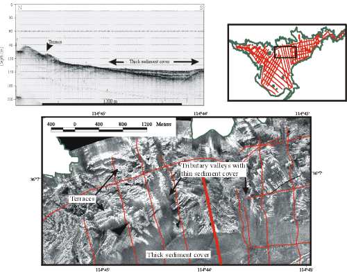
Surficial Geology and Distribution of Post-Impoundment Sediment of the Western Part of Lake Mead Based on a Sidescan Sonar and High-Resolution Seismic-Reflection SurveyFigure 9. Sidescan sonar image of part of the terraced rock outcrop that characterized much of the northern side of the lake (location in inset map). Terraces show as alternating bands of high and low backscatter on the sidescan while uniform low-backscatter along southern part of image is post-impoundment sediment. Small tributary valleys with low-backscatter floors have thin sediment cover. Seismic profile ( heavy red line on sidescan image) shows the gentler gradient and terraced nature of this side of the lake as well as post- impoundment sediment onlapping and burying this older surface. On the profile, 0.02 sec. Two-way travel time is approximately 15 m. Click on figure for larger image. | ||||||||||||||||||||||||
| ||||||||||||||||||||||||