Surficial Geology and Distribution of Post-Impoundment Sediment of the Western Part of Lake Mead Based on a Sidescan Sonar and High-Resolution Seismic-Reflection Survey
Methods
Click on each figure for larger image with caption.
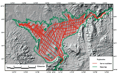
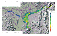
Figure 3. Tracklines in the Boulder Basin and Las Vegas Bay parts of Lake Mead along which sidescan sonar, subbottom seismic-reflection profiles, bathymetry, and navigation were collected. All four types of data were continuously collected along all of these lines.
A two-week sidescan sonar and high-resolution seismic-reflection survey was completed during May 12-26, 1999. Geophysical data were collected along approximately 335 km of survey tracklines (Fig. 3). The grid of survey lines, spaced 500-1000 m apart, provide complete sidescan sonar coverage of the study area except in some of the shallow parts of the lake, and allow a detailed mapping of the thickness and distribution of post-impoundment sediments within the study area. The survey was conducted aboard a 19-m houseboat. A Datasonics Inc. SIS-10001 sidescan sonar and chirp subbottom profiling system was used to collect the sidescan imagery and subbottom profile information. The sound source for the subbottom data was a chirp system with a central frequency of 3.5 kHz. Minimum resolution based on this frequency and the sampling interval used to log the data is approximately 50 cm. The sidescan imagery and subbottom data were logged digitally using an ISIS1 digital acquisition system developed by Triton-Elics Industries1. Both data types were collected on all tracklines. Single-beam bathymetry was collected along all the survey tracklines as well. All navigation was done with a P-Code GPS receiver with an estimated accuracy of +/- 10 m. The navigation information is stored every 10 seconds and includes Julian day, hour, minute, second, longitude, latitude, and depth. The time recorded with the navigation information is in UTC.
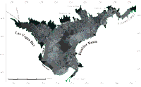
During the field operation, the sidescan sonar data were processed and a digital mosaic was completed. The sidescan imagery was demultiplexed, corrected for slant-range distortions and signal attenuation using techniques summarized by Danforth et al (1991). These strips of image data were then mapped into their proper geographic location using software described by Paskevich (1996).
Once the individual strips were mapped, they were combined together into a composite digital mosaic using a remote sensing software package developed by PCI (Anonymous, 1992). The techniques for generating the composite digital sidescan mosaic are summarized by Paskevich (1992). The completed mosaic has a pixel size of 2 m, and the image is in a UTM projection, zone 11 using the WGS-84 ellipsoid.
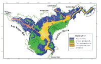
The sidescan sonar mosaic was imported into ESRI's ArcView GIS package where the image shown in Figure 4 and the interpretation shown in Figure 5 were generated. On the sidescan images presented in this report, a strong acoustic return, also referred to as high backscatter, appears as white and light gray tones. A weak acoustic return, low backscatter, is black or dark gray.
Processing of the seismic data involved two steps. The first step was to convert the seismic files from the ISIS format to SEG-Y format. This step also included correcting for the depth of the transducer since the sonar vehicle was not towed at the surface. This was accomplished using a conversion utility developed by the US Geological Survey which converts the data to a standard 16-bit unsigned integer SEG-Y format. This format is described in detail by Barry et al. (1975). The SEG-Y files consist of shot files with one trace per shot. Most of the data was collected using a 0.5 sec. firing rate, but some was collected using a 1.0 sec. firing rate. For the data collected at the 1 sec. fire rate, there were 2072 samples per trace with a sample interval of 488 microseconds. For the data collected at the 0.5 sec fire sate, there were 2144 samples per trace and the sample interval was 244 microseconds. Because the combined water depth and sediment thickness in the lake did not exceed 270 milliseconds, only the upper 300 milliseconds of each trace were used. The second step was to use the seismic processing package, SEISMIC UNIX (Cohen and Stockwell, 1997), to generate a postscript file of each seismic data file. This postscript file was then converted to 'GIF' format and down-sampled to 25% of the original size for analysis in the field.
After the cruise, the SEG-Y files were imported into Seisworks1 (Landmark Graphics Corp) where the interpretation of the profiles was completed.
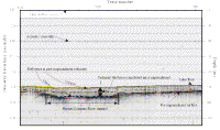
Figure 6 shows a part of one of the seismic profiles, and highlights the different horizons that were identified on each of the profiles. A velocity of sound of 1500 m/sec was used to convert travel times on the seismic profiles to depths. The present lake floor and the pre-impoundment surface were identified on each of the seismic profiles (Fig. 6), and the difference between these two reflectors was used to measure the thickness of the post-impoundment sediments (Fig. 7).
In addition to these two horizons, four other horizons were identified within the post-impoundment sedimentary section (Fig. 6). The thickness of sediment that has accumulated in the lake since impoundment was derived independently by subtracting a low-resolution version of the pre-impoundment elevation from the modern lake floor elevation. The thickness derived from the seismic-reflection profiles and that derived from subtracting the two elevations provided similar results except along the Colorado River. The pre-impoundment topography did not include river depths, so the sediment thickness along the former path of the Colorado River derived from the seismic profiles is significantly thicker. Because the seismic profiles information in the Colorado River bed, sediment thickness discussed in this report is only based on the seismic-reflection profiles.
Back to Mid-Page
1 The use of trade names is for descriptive purposes only and does not indicate endorsement by the U.S. Geological Survey, nor the University of Nevada, Las Vegas.
|