Surficial Geology and Distribution of Post-Impoundment Sediment of the Western Part of Lake Mead Based on a Sidescan Sonar and High-Resolution Seismic-Reflection Survey
Introduction
Click on figure for larger image.
Figure 1. Location map showing the morphology of the western part of Lake Mead and the surrounding area. Morphology is shown as a shaded-relief image that was derived from combining a digital elevation model of the surrounding landscape (USGS, 1999) with a gridded version of the bathymetry collected during this survey. Green line is the approximate location of the shoreline (360 m contour), and names are places referred to in the text. Inset shows the location of the study area (yellow box).
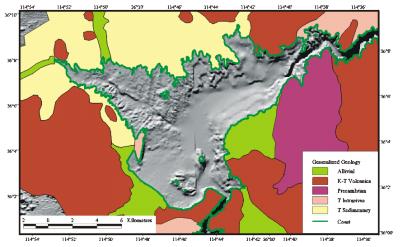
Lake Mead is a large interstate reservoir located in the Mojave Desert of southeastern Nevada and northwestern Arizona (Fig. 1). It was impounded in 1935 by the construction of Hoover Dam and is one of a series of multi-purpose reservoirs on the Colorado River. The lake extends 183 km from the mouth of the Grand Canyon to Black Canyon, the site of Hoover Dam, and is surrounded by Precambrian through Tertiary aged volcanic and intrusive rocks as well as Tertiary sedimentary strata and Quaternary alluvial deposits (Fig. 2). It provides water for residential, commercial, industrial, recreational, and other non-agricultural users in communities across the southwestern U.S.
Click on figure for larger image.
Figure 2. Generalized geology of the area surrounding Lake Mead. Geology of Arizona is modified from Wilson et al. (1969), and geology of Nevada is modified from Stewart and Carlson (1978). Alluvial is mostly Quaternary and recent unconsolidated alluvial gravel, sand and silt. K-T Volcanics are mostly Cretaceous and Tertiary andesitic and basaltic flows. T Intrusives are mostly Tertiary aged rhyolitic flows and shallow intrusive rocks including diorite and granite. T Sedimentary are Tertiary aged tuffaceous sedimentary rocks. Precambrian includes gneiss and some areas of undivided schist and granite of Precambrian age.
The Colorado River, via discharges from Lake Powell, supplies approximately 98% of the annual inflow to Lake Mead (Preissler et al, 1998, Water Resources Data, Arizona, Water Year 1998, 1998). The remainder is derived from the Virgin and Moapa Rivers which discharge into the Overton Arm, the Las Vegas Wash which discharges into Las Vegas Bay, and a number of desert washes which surround the lake. Outflows from Lake Mead include the Colorado River (below Hoover Dam) and water diversions located at Saddle Mountain (Fig. 1) and in the Overton Arm. These diversions provide water for municipal and industrial uses for the greater Las Vegas Metropolitan area and Moapa Valley, respectively.
The impact of these inflows on the ecosystem of Lake Mead has been well documented (Pressler, et al., 1998; Bevans et al, 1996; Bevans et al., 1998; Covay and Leiker, 1998; LaBounty and Horn, 1997; Paulson, 1981). Much of the work has been conducted in Las Vegas Bay and Boulder Basin of Lake Mead (Fig. 1) due to the proximity to the potable water intakes at Saddle Mountain. A majority of the studies involved determining levels of anthropogenic contaminants such as synthetic organic compounds, heavy metals and dissolved ions, furans/dioxins, and nutrient loading in lake water, sediment, and biota. However, little work has focused on the transportation and deposition of sediments in Las Vegas Bay and Boulder Basin. These sediments are known to be largely silts that have been transported along the lake floor by turbidity currents active in the original Colorado River bed (Gould, 1951). By 1947, in excess of 30 m of sediment had accumulated behind Hoover Dam (U.S. Bureau of Reclamation, 1947; Gould, 1951; Vetter, 1953). In 1965, the Glen Canyon Dam was built on the Colorado River approximately 300 km upstream of Lake Mead (Lucchita and Leopold, 1999). The effect of this dam on sedimentation in Lake Mead is not well understood. The purpose of this exploratory study is to utilize sidescan sonar imagery and high-resolution seismic reflection profiles to determine the surficial geology as well as the distribution and thickness of sediment that has accumulated in Las Vegas Bay and Boulder Basin of Lake Mead.
|