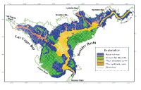
Surficial Geology and Distribution of Post-Impoundment Sediment of the Western Part of Lake Mead Based on a Sidescan Sonar and High-Resolution Seismic-Reflection Survey
Discussion
Part I
Click on each figure for larger image with caption.
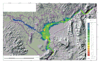
The sidescan sonar imagery and high-resolution seismic-reflection profiles provide a detailed overview of the lake-floor geology
and the thickness and distribution of sediments that have accumulated in the lake since its initial formation. Because no cores or surface sediment samples are available, the interpretation presented here is based exclusively on the geophysical data and undoubtedly will be refined with the addition of ground-truth information. Even without ground-truth information, however, certain observations can be made as to the distribution of sediment within the lake and as to the processes by which it was deposited.
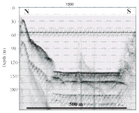
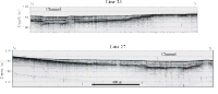
Much of the lake-floor geology mimics the geology of the surrounding landscape. Adjacent to steep rock cliffs the seismic profiles and sidescan sonar imagery show steep cliffs (Fig. 8). Adjacent to alluvial fans the morphology of the lake floor mimics the on-land parts of these fans, and the sidescan imagery shows the same intricate network of channels that is seen on the subaerially exposed parts of these fans (Fig. 10).The preservation of these pre-impoundment geological features suggests that virtually no sediment has accumulated on these areas. If there were sediment covering these areas, it must be less than 0.5 m thick, otherwise it would be apparent on the seismic profiles that cross these areas (Fig. 9, Fig. 10).
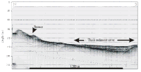
The distinctive distribution of post-impoundment sediments in the lake indicates processes of transport that are restricted to the axes of the submerged valley
floors rather than sediment being deposited as a drape across the entire lake floor (Fig. 5, Fig. 7).
Furthermore, the flat-lying reflectors in the sediments that fill the deep part of the lake indicate a vertical filling process rather than a process by which a blanket of sediment has draped the entire lake floor (Fig. 8, Fig. 11).
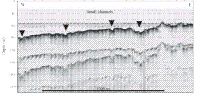
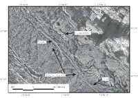
The preservation of the morphology of the surface of the alluvial deposits is of additional interest because it implies little reworking of the lake floor during the flooding of the lake and since the lake became full. These alluvial deposits consist of unconsolidated silt, sand, and gravel (Wilson et al., 1969) that would be remobilize if strong bottom currents or large waves were present in the lake. The preservation of the alluvial surfaces and the presence of what appear to be a road and a narrow trail that were created prior to the formation of the lake indicates that processes acting on the lake floor as lake level rose and since then have been insufficient to erase these features (Fig. 14).
The only evidence of pre-impoundment deposits being reworked is in water depths shallower than 18-20 m. Figure 15 shows some alluvial channels that abruptly end in about 18-m water depth. Shoreward of this depth, the lake floor has a more uniform high-backscatter appearance that suggests a continuous smooth sheet of sand. This smooth sand sheet may reflect reworking and redistribution of the unconsolidated alluvial deposits by storm waves breaking on the beach. The 18-m depth, however, is deeper than the depth to which significant reworking of sediment occurs on high-energy coasts (Komai, 1997). In Lake Mead, this depth probably is more indicative of the maximum lowering of the lake surface since initial filling rather than being an indication of wave energy.
|