National Assessment of Coastal Vulnerability to Sea-Level Rise: Preliminary Results for the
U.S. Atlantic Coast
U.S. Geological Survey Open-File
Report 99-593
E. Robert Thieler and Erika S. Hammar-Klose
Woods Hole, Massachusetts 1999
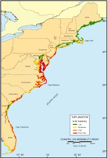
Click on figure for larger view. |
Figure 1. Map of the Coastal Vulnerability Index (CVI) for the U.S. Atlantic coast. The CVI shows the relative vulnerability of the coast to changes due to future rise in sea-level. Areas along the coast are assigned a ranking from low to high risk, based on the analysis of physical variables that contribute to coastal change.
One of the most important applied problems in coastal geology
today is determining the physical response of the coastline to
sea-level rise. Prediction of shoreline retreat and land loss rates
is critical to the planning of future coastal zone management
strategies, and assessing biological impacts due to habitat changes
or destruction. Presently, long-term (>50 years) coastal
planning and decision-making has been done piecemeal, if at all,
for the nation's shoreline (National Research Council, 1990; 1995).
Consequently, facilities are being located and entire communities
are being developed without adequate consideration of the potential
costs of protecting or relocating them from sea level rise-related
erosion, flooding and storm damage.
|