National Assessment of Coastal Vulnerability to Sea-Level Rise: Preliminary Results for the U.S. Atlantic Coast
Coastal Vulnerability Index (CVI)
The coastal vulnerability index (CVI) presented here is similar
to that used by Gornitz et al. (1994), as well as to the
sensitivity index employed by Shaw et al. (1998). The index allows
the six physical variables to be related in a quantifiable manner.
This method yields numerical data that cannot be directly equated
with particular physical effects. It does, however, highlight those
regions where the various effects of sea-level rise may be the
greatest.
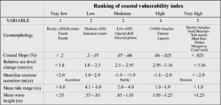 |
| Table 1. Ranking of coastal vulnerability index variable. Click on figure for larger image. |
Once each section of coastline is assigned a risk value based on
each specific data variable, the coastal vulnerability index is
calculated as the square root of the geometric mean, or the square
root of the product of the ranked variables divided by the total
number of variables as
where,
- a = geomorphology
- b = coastal slope
- c = relative
sea-level rise rate
- d = shoreline erosion/accretion rate
- e = mean
tide range
- f = mean wave height
|
