Open–File Report 2000–0347
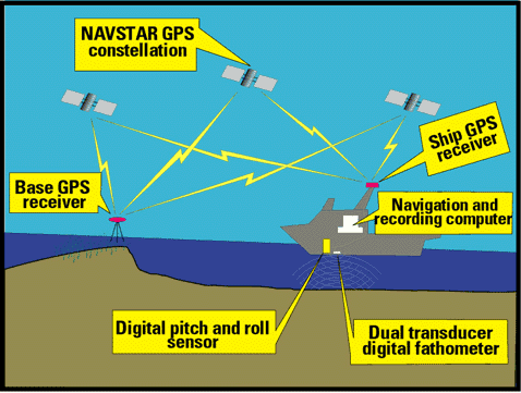
Bathymetric positions for this study were derived using differential GPS techniques on 10-km baselines or less. One or more GPS reference stations (base stations) were continuously recording full-phase carrier data while the boat surveyed. A rover GPS receiver on the boat was simultaneously recording carrier information. Below is a cartoon example depicting a typical bathymetric survey and the communication links needed to obtain precise positions and measurements.
Record epoch intervals was 1 second for both base station and rover receivers. Precise positions for each epoch were computed using Ashtech Precise Differential GPS Navigation and Surveying (PNAV) v2.0 software. PNAV provides a root mean squared (RMS) value for each epoch. For this study, a RMS value of 0.08 cm or less was considered reasonable. A RMS value of 1.0 indicates that the GPS data ambiguities were unresolved, and that the depths were determined by a tie-line best-fit method. For data format consistencies, RMS values for the 1890's data set are equal to 0.0. The horizontal positions of each data point were transformed from Latitude/Longitude to UTM (Zone 17) XY coordinates using NOAA/NGS software UTMSv1.0. Vertical positions were converted from ellipsoid height to orthometric height using NOAA/NGS software GEOID96, where, orthometric height is considered to be equal to NAVD88. According to NOAA tidal datum information, NAVD88 is approximately 0.41m (1.35 ft) above MLW in the Florida Bay area. The 1.35 feet average is calculated using the elevation information from several tidal benchmarks throughout the Florida Keys. These tidal benchmarks are published by the National Geodetic Survey and can be located on their website http://www.ngs.noaa.gov/cgi-bin/ngs_opsd.prl/. Five tidal benchmarks were chosen from four different U.S. Geological Quadrangle locations including Blackwater Sound, Plantation Key, Long Key and Grassy Key. The following table is a quick reference of information for the five tidal benchmarks.
To compare this data set with other depth information, which is relative to MLW, e.g. NOAA nautical charts, 0.41 m (1.35 ft) is algebraically subtracted from each depth value or contour line.
Example: To find MLW for a depth value of 2.55 ft:
MLW = 2.55ft - 1.35ft = 1.2 ft
PID #
Designation
USGS Quadrangle
NAVD88 (FT)
MLW (FT)
Difference (FT)
AC1028
W273
Blackwater Sound
1.44
0.07
1.37
AA0934
8723776
Plantation Key
1.36
0.04
1.32
AA0383
G278
Long Key
1.46
0.11
1.35
AA0815
8723887
Long Key
1.45
0.11
1.34
AA0352
H328
Grassy Key
1.63
0.27
1.36
AVG
1.35
File data formats are as follows:
ASCII file data formats for both the 1890s and 1990s data sets are as follows:
Column 1: X or Easting, meters, UTM Zone 17, NAD83/GRS80
Column 2: Y or Northing, meters, UTM Zone 17, NAD83/GRS80
Column 3: Z, meters, elevation relative to NAVD88
Column 4: RMS, meters, computed from Ashtech PNAV software; 0.0 for the 1890's data set

![]() U.S. Department of the Interior |
U.S. Geological Survey
U.S. Department of the Interior |
U.S. Geological Survey
URL: http://pubsdata.usgs.gov/pubs/of/2000/0347/bathymetric.html
Page Contact Information: GS Pubs Web Contact
Page Last Modified: Tuesday, 07-Jun-2022 08:05:05 EDT
