Open–File Report 2000–0347
Florida bay was mapped by using a shallow-draft boat equipped with a high-precision Global Positioning System (GPS) coupled with a high-precision depth sounder. To accomplish this task, SANDS (System for Accurate Nearshore Depth Surveying) was developed by Mark Hansen and Jeff List of the US Geological Survey. SANDS utilizes differential GPS receivers, a digital fathometer, a heave-roll-pitch sensor, and a shallow-draft boat. The SANDS system is accurate to approximately 4 cm horizontally and 8 cm vertically and collects data in water depths as shallow as 30 cm. To achieve this accuracy, the boat's roving distance from any one GPS reference receiver location must be within a 10-kilometer radius.
Data was collected on a USGS 7.5-minute quadrangle-by-quadrangle basis, proceeding westward from Blackwater Sound. The trackline spacing varied depending upon the relief of the sea floor; that is, closer spacing adjacent to mudbanks and wider spacing in the basins. Tracklines were surveyed in a north-south orientation, and crossings (intersecting tracklines) were surveyed in an east-west orientation. Crossing lines are critical because they served as a check on the accuracy of the system. In theory, data values at the crossing should be exactly the same. In reality, this is not always the case due to random errors of each sensor. Eighty-five percent of the crossings in this data set were within +/- 6 cm with the balance within +/- 20 cm.
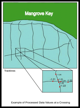
Ideally, crossings are made at the end of the survey day, however, some of the crossings were made months and even years after an area was initially surveyed. The results are very good considering the soft bottom characteristics of Florida Bay.

![]() U.S. Department of the Interior |
U.S. Geological Survey
U.S. Department of the Interior |
U.S. Geological Survey
URL: http://pubsdata.usgs.gov/pubs/of/2000/0347/mapping.html
Page Contact Information: GS Pubs Web Contact
Page Last Modified: Tuesday, 07-Jun-2022 07:59:11 EDT
