|
| Seismic and Tsunami
Hazards in Northeast Caribbean Addressed at Meeting
William Dillon 1., Uri ten Brink 1., Arthur Frankel 2., Rafael Rodriguez 3., and Charles Mueller 2. 1. Coastal and Marine Geology Program, U.S. Geological Survey, Woods Hole,
Massachusetts, USA
|
| Significant earthquake and tsunami hazards exist in the
northeastern Caribbean, where plate movements are rapid and complex, and population
density is high. The tectonic situation at this "corner," where a small plate is
shoved over a larger one, is of considerable scientific significance. Evaluation of the
tsunami hazard and earthquake risk in this region of 3.7 million people, which includes
Puerto Rico and the U.S. Virgin Islands, requires understanding the rapid plate motions
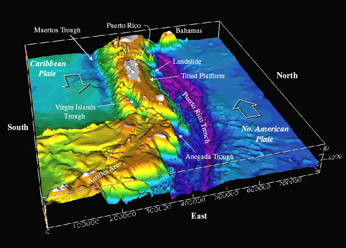
that occur there. At a workshop this past March sponsored by the U.S. Geological Survey (USGS), a group of scientists, engineers, and government and industry representatives set about to determine critical elements that would be required in a comprehensive program of scientific research, management, and public education concerning the tectonic risk in the region. Participants called for work in marine geology and geophysics, paleoseismology and active faults, earthquake seismology, engineering, and tsunami research. In particular, the participants concluded that offshore faults, their level of seismic activity and, if possible, slip rates, must be better identified, and a better historic and prehistoric record of earthquake and tsunami activity on the islands must be established. The workshop also provided an effective forum for communication among people with highly varied purposes and expertise, from academic researchers to representatives of insurance and telephone companies, but all having the shared goal of understanding and ameliorating the tectonic hazards of this part of the world. Participants hoped it was a positive first step in a dialogue that will encourage support for science, engineering, education, and effective governmental action on this problem. Puerto Rico, the Virgin Islands to its east, and eastern Hispaniola to its west exist on microplates located in an active plate boundary zone between the North American plate and the northeast corner of the Caribbean plate (see Figure 1). The Caribbean plate is roughly rectangular, and it slides eastward at about 2 cm/yr relative to the North American plate. Motion along its northern boundary (in the plate boundary zone region) is dominantly strike-slip, with perhaps a small component of shortening. In contrast, on its eastern boundary, the Caribbean overrides the North American plate, creating the island arc of the Lesser Antilles. The Puerto Rico trench, the deepest trench in the Atlantic, which has the world's largest negative free-air gravity anomaly, lies within the zone of dominantly strike-slip motion --- clearly an enigma. Pliocene shallow-water limestone platform deposits of northern Puerto Rico have been strongly and rapidly tilted northward in the last few million years; the strata have been elevated above sea level on Puerto Rico and subsided to depths of 5 km on the northern insular slope. The tilting has caused major rock slides, leaving scars that are tens of kilometers wide. The tectonic setting of the region probably includes interaction of major plates (Caribbean and North American plates) at great depths and also semi-independent movement of microplates in the broad plate boundary zone. As the motions are very poorly known, the controls on earthquakes in the region also are very poorly understood. The region has high seismicity and large earthquakes. Examples include a magnitude 7.5 earthquake centered northwest of Puerto Rico in 1943 and magnitude 8.1 and 6.9 earthquakes north of Hispaniola in 1946 and 1953, respectively. Historically, other large earthquakes have also struck the area, such as one in 1787 (M ~8.1), possibly in the Puerto Rico trench, and one in 1867 (M ~7.5) in the Anegada trough (see Figure 1). A draft USGS hazard map places equal probability for damaging ground motion for Mayaguez in western Puerto Rico as for Seattle, Washington; other Puerto Rican cities also have substantial risk. The hazard from tsunamis is also apparent. Immediately after the 1946 earthquake, a tsunami struck northeastern Hispaniola and propagated inland for several kilometers; some reports indicate that nearly 1800 people drowned. A 1918 M 7.5 earthquake resulted in a tsunami that killed at least 91 people in northwestern Puerto Rico. Eyewitness reports of an 1867 Virgin Islands tsunami give a maximum wave height of >7 m in Frederiksted, St. Croix, where a large naval vessel was left on top of a pier. Essentially all of the known causes of tsunamis are present in the Caribbean -- earthquakes, submarine landslides, submarine volcanic eruptions, subaerial pyroclastic flows into the ocean, and teletsunamis. Because of great population density and extensive construction near the coast a significant earthquake and tsunami risk exists. The workshop brought together for the first time a broad spectrum of scientists, engineers, and public and private sector officials who deal with such diverse questions as tectonic models, probabilistic assessment of seismic hazards, prediction of tsunami run-up, strong ground motion, building codes, stability of manmade structures, and the public's preparedness for natural disasters. It was an opportunity for the more than 100 participants to find out how their own activity fits into the broad picture of science and how it aids society in hazard assessment and mitigation. The workshop also was offered as a continuing education course by the Colegio de Ingenieros y Agrimensores de Puerto Rico (Association of Engineers and Surveyors of Puerto Rico), which assured a rapid dissemination of the results to the local community. Participants began by reviewing the present state of knowledge. This included review and discussion of present plate models, recent Global Positioning System (GPS) and seismic reflection data, seismicity, paleoseismology, and tsunamis. The state of earthquake/tsunami studies in Puerto Rico was presented by several faculty members from the University of Puerto Rico at Mayaguez, and applicable techniques were discussed. A trial version of a seismic hazard map was presented by USGS and previous hazard maps and economic loss assessments were discussed. Participants then divided into working groups and prepared specific recommendations for future activities in the region on six topics. In marine geology and geophysics, recommendations included acquiring deep-penetration seismic reflection and refraction data for deep structure, deploying temporary ocean bottom seismometer arrays to record earthquakes, collecting high-resolution multibeam bathymetry and side-scan sonar data of the region (particularly nearshore) to define fault patterns and facilitate tsunami modeling, and conducting focused high-resolution seismic studies around faults to attempt slip-rate estimation. Also suggested was assembling a Geographic Information System database of available marine geological and geophysical data. A working group in paleoseismology and active faults recommended carrying out field reconnaissance studies to identify Quaternary faults, determining their paleoseismic chronology and slip rates, and identifying and dating paleoliquifactions. The group also advised cooperating with marine geologists to identify faults in the nearshore region and extending their mapping onshore, mapping Quaternary marine terraces, fluvial terraces and basins, beach ridges, and so forth, using new GPS data to establish a framework for understanding neotectonic deformation of the island, and interpreting aerial photography to identify possible Quaternary faults. In earthquake seismology, recommendations included determining an empirical seismic attenuation function using observations from local seismic networks and recently installed broadband stations, evaluating existing earthquake catalogs from local networks and regional stations and completing the catalogs, transcribing pre-1991 network data from 9-track tape onto more stable archival media, calibrating instruments of local networks, and using GPS measurements to constrain deformation rates in seismic hazard maps. An engineering working group suggested preparing liquefaction-susceptibility maps for the urban areas, updating and improving databases for types of site conditions, and collecting site-effect observations and near-surface geophysical measurements for future local (urban-area) hazard maps. It also advised expanding the number of instruments in the strong motion program, developing fragility curves for Puerto Rico construction types and details, carrying out laboratory testing on selected types of mass-produced construction, and considering tsunami design in shoreline construction projects. Recommendations concerning tsunami hazards included extracting tsunami observations from archives and developing a Caribbean historical tsunami database, and analyzing prehistoric tsunami deposits. Also suggested were collecting accurate, up-to-date, nearshore topography and bathymetry for accurate inundation models, preparing tsunami flooding and evacuation maps, establishing a Caribbean Tsunami Warning System for Puerto Rico and the Virgin Islands, and evaluating local, regional, national, and global seismic networks and equipment, and their role in a tsunami warning system. A working group on societal concerns recommended preparing warning messages, protocols, and evacuation routes for earthquake, tsunami, and landslide hazards, advocating enforcement of existing building codes, preparing nontechnical hazard-assessment maps for political and educational uses, and raising the awareness of potentially affected populations by presentations at elementary schools, by the production of a tsunami video, and by distribution of earthquake preparedness manuals in newspaper supplements. The group also advised promoting partnerships at state and federal levels for long-term earthquake and tsunami hazard mitigation. These partnerships would also include private sector groups such as the insurance industry, telecommunication companies, and the engineering community. A more complete report on the workshop is available on the Web (http://woodshole.er.usgs.gov/puertoricoworkshop).
|