|
||||||||||||||||
Sedimentary Processes in a Tectonically Active Region: Puerto Rico North Insular Slope
|
||||||||||||||||
|
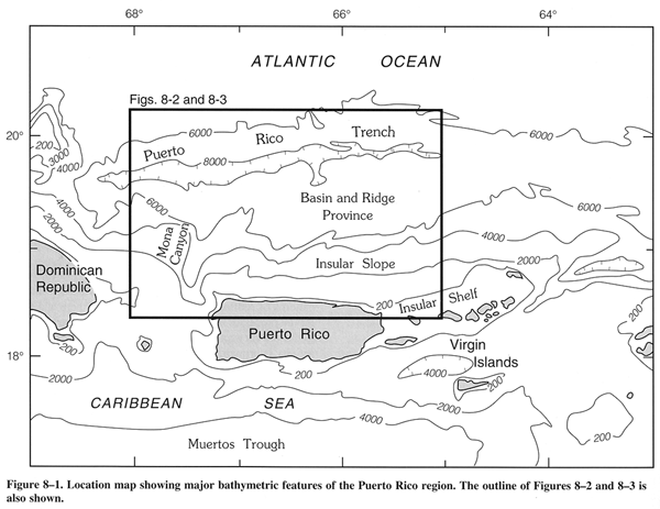
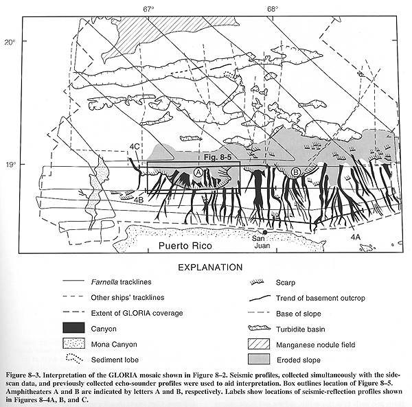
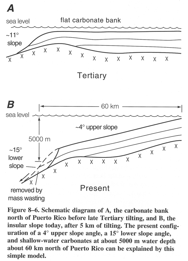
GLORIA long-range sidescan-sonar data extending from the shelf edge north of Puerto Rico across the insular slope to the floor of the Puerto Rico Trench reveal numerous canyons, amphitheater-shaped scarps, and sediment ponds. Interpretation of these data, in light of previously collected geophysical and sample data, indicates that tectonic forces have played a major role in the depositional and erosional history of the study area. Regional northward tilting of the flat, shallow-water Tertiary carbonate bank north of Puerto Rico created the insular slope and set the stage for the development of submarine canyons. The distinctive morphology of these canyons can be attributed to the character of the strata into which they have been cut. The front of the former carbonate bank has been eroded by large-scale mass-wasting which has left large amphitheater-shaped scarps on the lower slope. Shelf-derived sediment, along with material eroded from the canyon walls, is transported through the canyons to the basin and ridge province at the base of the slope where most sediment is trapped in basins south of the trench floor. The discovery of a depositional lobe on the trench floor confirms the presence of a turbidite entry point and suggests that some sediment reaches the trench floor as well. The deepest part of the Puerto Rico Trench, which has depths in excess of 8,000 meters (m), lies 150 km north of the island of Puerto Rico (Fig. 1). The area between the island and the trench is made up of a steep insular slope, extending to a depth of about 7,000 m, and an 80-km-wide basin and ridge province which separates the trench floor from the insular slope. Although sediment of shallow water origin, derived from the vicinity of Puerto Rico, has been identified in cores taken in the trench, little attempt has been made to understand the processes which have operated to transport the sediment across the intervening morphologically complex area. The major aims of this study are to describe the morphology of the insular slope north of Puerto Rico and the patterns of sedimentation and erosion seen there, and to infer the processes which have created them. It is also necessary to discuss the tectonic setting of the area, since tectonic activity is primarily responsible for the overall morphology and sedimentation pattern. Regional northward tilting of the northern insular slope of Puerto Rico since early Pliocene and seismic activity which continues to the present day are probably the two most important tectonic influences (Masson and Scanlon, 1991). THE STUDY AREA: BACKGROUND Morphology The study area includes the seafloor between the island of Puerto Rico and the Puerto Rico Trench floor and extends west to Mona Canyon and east to the U.S. Virgin Islands (fig. 1). Bathymetric maps and seismic-reflection profiles (e.g., Maley, Sieber and Johnson, 1974; Tucholke and Ewing, 1974; National Ocean Survey, 1980; Trumbull, 1981), give the general form of the sea floor in the study area. The insular shelf north of Puerto Rico is narrow, generally less than 5 km wide, whereas further east the Virgin Islands Shelf widens to about 25 km. The shelf edge occurs at a water depth of 100 m or less. The insular slope is steep and convex in cross-section. The upper slope extends form the shelf edge to about 3000 m depth and has an average gradient of about 4 degrees. The lower slope extends from 3000 m to 7000 m and has an average gradient of 15 degrees or more. Locally the slope can be vertical (Gardner, Glover, and Hollister, 1980). Numerous canyons, up to 400 m deep (Trumbull, 1981), have been recognized on the upper slope. Mona Canyon is a wide flat-floored canyon near the western edge of our study area (Fig. 1), which differs from the other canyons north of Puerto Rico in that it is larger and probably fault-controlled (Gardner et al., 1980). Between the base of the insular slope (at about 7000 m) and the trench floor is a region referred to as the basin and ridge province (Masson and Scanlon, 1991). Within this province east-southeast trending ridges exhibit several hundred meters of local relief, and basins containing flat-lying sediments are distributed irregularly in the inter-ridge areas (Masson and Scanlon, 1991). The Puerto Rico Trench lies north of the basin and ridge province. It is flat-floored, sediment-starved and, at 8000 m deep, the deepest part of the Atlantic Ocean. Tectonic setting Puerto Rico and the Virgin Islands lie within the North American-Caribbean plate boundary zone which extends from the Puerto Rico Trench in the north to the Muertos Trough in the south (Fig.1) (e.g., Burke et al., 1984; Dillon, Edgar, Scanlon, and Coleman, this volume). Until Eocene time the region experienced north-south convergence; since the end of the Eocene the relative plate motion has been mainly left-lateral slip (Burke et al., 1984; Stein et al., 1988). Deformation due to plate interactions is complex and extends across the entire plate boundary zone. Recent explanations for the observed complexity include Heubeck and Mann's (1991) proposal that the Caribbean plate may actually consist of three or more sub-plates, and Masson and Scanlon's (1991) suggestion that one or more microplates may exist, and move semi-independently, within the plate boundary zone. Seismic activity, extending to depths of at least 150 km, confirms that deformation is active to the present day (Frankel, McCann, and Murphy, 1980; Sykes, McCann, and Kafka, 1982; Mann and Burke, 1984). An important aspect of the regional tectonics is the large amount of late Tertiary tilting which has affected the northern insular slope of Puerto Rico. Birch (1986) has suggested that this tilting could have caused as much as 8 km of subsidence of the lower slope since the middle Eocene. Certainly, the occurrence of in-place shallow-water Miocene to early Pliocene limestones at depths in excess of 5 km demonstrates at least 5 km of subsidence in less than 4 million years (my) (Moussa, Seiglie, Meyerhoff, and Taner, 1987). Further evidence for large-scale subsidence comes from the recognition of karst topography in Tertiary limestones at depths to 2,100 m (Heezen, Nesteroff, Rawson, and Freeman-Lynde, 1985). Rocks The mountainous core of Puerto Rico consists mainly of Cretaceous and Early Tertiary volcanic rocks which have been folded into an anticlinorium and intensely faulted. This core is flanked by Tertiary sedimentary rocks, predominantly shallow-water limestone (Monroe, 1980). Following the nomenclature of Moussa et al. (1987) and the lithologic descriptions of Monroe (1980), the lowermost of the Tertiary sedimentary units is the San Sebastian Formation (0-300 m thick), a sandy carbonaceous clay, locally containing conglomerates and lignites. It is overlain by the Lares Limestone (0-500 m thick), a hard, very pure, fossiliferous limestone in beds 10-30 cm thick, followed by the Cibao Formation (170-300 m thick), a calcareous clay and earthy limestone. The Los Puertos Limestone (90-150 m thick) is indurated in its upper part and chalky in the lower parts, and forms a transition between the underlying earthy Cibao Formation and the overlying Aymamon Limestone, a very pure, thick-bedded, massive, fossiliferous limestone, about 200 m thick. An unconformity separates the Aymamon Limestone from the uppermost of the Tertiary sedimentary units, the Quebradillas Limestone, a thin-bedded, sandy limestone and chalk, about 170 m thick. On the northern flank of Puerto Rico the Tertiary sedimentary units mapped on land can be traced offshore for 50 km using seismic reflection profiles (Moussa et al., 1987). They are parallel-bedded and have a regional northward dip of 4 degrees, approximately the same angle as the seafloor of the upper slope. The shallow-water depositional environment and parallel-bedded character of the limestones require that the 5 km of subsidence recorded on the lower slope must be a post-depositional event, that is, it must have occurred after early Pliocene. Several publications have described rocks dredged from our study area (Schneidermann, Beckmann, and Heezen, 1972; Shido, Miyashiro, and Ewing, 1974; Fox and Heezen, 1975; Perfit, Heezen, Rawson, and Donnelly, 1980). The majority of the samples are from the steep lower slope. East of Mona Canyon (Fig. 1), most of the lithologies recovered from the lower slope are middle Tertiary limestones or pre-Eocene rocks of similar aspect to those known in Puerto Rico. West of Mona Canyon, a more diverse suite of rocks has been recovered, including calcarenites, calcilutites, marbles, and low grade metavolcanics and schists. The affinities of these rocks appear to be with northern Hispaniola and the carbonate banks of the southern Bahamas, rather than Puerto Rico (Perfit et al., 1980). Only two dredge hauls have been recovered from the basin and ridge province (Shido et al., 1974; Perfit et al., 1980). One, located at 19d20'N, 65d32'W, contained an assemblage of rocks typical of the lower slope, even though it was collected from a ridge separated from the lower slope by a 15-km-wide sedimentary basin. The second, located just to the east of the GLORIA coverage at 19d36'N, 65d04'W, recovered a different assemblage, consisting of tholeiitic volcanic rocks, which represents oceanic material derived from the North American Plate. Sedimentary processes Sediment deposition and movement on the insular shelf north of Puerto Rico have been the subjects of several studies (e.g., Schneidermann, Pilkey, and Saunders, 1976; Pilkey, Trumbull and Bush, 1978; Grove, Pilkey, and Trumbull, 1982; Pilkey, Bush, and Rodriguez, 1987). The dominant shelf sediment type is calcareous skeletal sand, but a significant amount of terrigenous material is deposited near the numerous river mouths during storms. These sediments are believed to move both laterally along the shelf and seaward into canyon heads, but the relative importance of these two processes is not known. The mouths of the rivers that contribute these sediments are spaced about 5 to 10 km apart along the coast and some are known to have shifted in location by several kilometers (Bush, Pilkey, and Rodriguez, 1986; Rodriguez, Webb, Bush, and Scanlon, 1992) during the Holocene. Canyons were recognized on the insular slope north of Puerto Rico as early as the mid-1950's (Northrop, 1954; Ewing and Heezen, 1955). The upper parts of three canyons off northwestern Puerto Rico were studied in the 1970's by Gardner et al. (1980) using research submersibles. They concluded that the canyons are not active during the present high sea-level stand; indeed the upper parts of the canyons appeared to be filling with terrigenous mud. However, past episodes of erosion, which incised the canyons into the consolidated Tertiary limestones, were inferred from the occurrence of scarps, ledges, and perched limestone boulders on the canyon walls. The distribution of the most recent turbidites across the basin and ridge province and onto the main abyssal floor of the Puerto Rico Trench was described by Doull (1983) using a suite of 44 piston cores. She was able to demonstrate that turbidite sands consisted primarily of shallow-water carbonate material derived from the Puerto Rico shelf. Rock fragments, including some of lithified limestone, are present in the turbidites but are not an important constituent. By mapping the thicknesses of basal sand layers, Doull was able to identify five distinct entry points for turbidity currents into the Puerto Rico Trench, distributed along the 360 km length of the trench studied. One of the turbidites entered the trench from all five entry points, suggesting simultaneous failure of a considerable length of the Puerto Rico slope. Such a widespread failure is likely to have been triggered by a large seismic event. Data for the present study were collected during a 30-day cruise on the research vessel FARNELLA in late 1985 and consist of GLORIA long-range sidescan-sonar imagery (fig. 2), 80-cubic-inch airgun seismic reflection profiles, and 3.5 kilohertz (kHz) and 10 kHz echo-sounder profiles (EEZ-SCAN 85 Scientific Staff, 1987; Scanlon, Masson, and Rodriguez, 1988). All of these data were collected simultaneously along the FARNELLA tracklines shown in figure 3. In addition, data from the archives of the Woods Hole Oceanographic Institution and Lamont-Doherty Geological Observatory were used to aid in the interpretation of the GLORIA mosaic. These include echo-sounder profiles, core descriptions, and bottom photographs . Technical details about the GLORIA system and information about processing and mosaicking the images can be found in the introductory chapters of this book. Light and dark areas in the GLORIA images represent areas of the sea floor that produce high and low backscatter, respectively. The intensity of backscatter is affected by the angle of the sea floor relative to the incidence angle of the sonar signal (i.e., bathymetry) and changes in the character (e.g., composition or degree of lithification) of the sea bottom. Small-scale roughness or inhomogeneities on the surface of the sea floor, of similar magnitude to the GLORIA wavelength of 23 cm, have usually been considered to be the principle contributor to backscatter intensity (see Huggett and Somers, 1988). However, it is now recognized that, in sedimented areas, significant sub-seabed penetration of energy may occur at the GLORIA frequency. Penetration to at least 5 m is well documented (Gardner et al., 1991; Huggett, Cooper, Somers, and Stubbs, 1992). Although taking penetration into account makes interpretation more complicated, this phenomenon can be exploited. For example, GLORIA has been used to map debris flows buried by as much as 3 m of turbidites off west Africa (Masson et al., 1992). Clearly, in interpretations of backscatter patterns, the assumption that GLORIA shows only seabed character and presently active sedimentary processes is incorrect. The GLORIA signal may be an integrated response from complex sub-seabed sediments representing several depositional and erosional episodes. At least some elements of the following interpretation must be viewed in these terms. The upper slope The upper slope extends from the shelf edge to a water depth of about 3000 - 4000 m. The GLORIA mosaic of the upper slope reveals dozens of downslope-trending canyons (fig. 2), which can be traced for 30 to 50 km, across the entire width of the upper slope. In cross-section, the canyons range from V- to U-shaped, with the latter being more common. Canyons appear on the GLORIA image as areas of high backscatter, which correspond to the canyon floors and walls, from rim to rim, and not just to the canyon floors. We believe the high backscatter results from outcrops of the Tertiary limestone beds into which the canyons are cut and from talus and coarse sediments within the canyons. Limestone outcrops, talus, and coarse sediments have been observed during submarine dives in the upper parts of canyons in the western part of our study area (Gardner et al., 1980; Heezen et al., 1985). Accumulations of shelf-derived sediments have been reported in some canyons (Gardner et al., 1980), but these are generally thin and the GLORIA signal probably penetrates them. Near the top of the slope (fig. 4A) the canyons are narrow (100 to 500 m wide) and closely spaced (generally less than 4 km apart). At a regional water depth of between 500 m and 800 m, the canyons are incised as much as 400 m into the dipping limestone strata. The depth of canyon incision gradually decreases downslope, with canyons at 2,250 m typically being incised to only about 100 m (fig. 4B). At this depth, many of the canyons have merged into the broader, straighter canyons which typify the deep part of the upper slope. Some "canyons" on the deep upper slope have little or no bathymetric relief in our seismic profiles, but show clearly on the GLORIA mosaic as stripes of high backscatter, and are continuous with deeply incised canyons on the shallow upper slope. In these cases, the high backscatter may indicate areas where a thin layer of unconsolidated sediment has been stripped away, exposing the underlying consolidated Tertiary units; alternatively, it may arise from trails of debris or coarse-grained sediment derived from the canyons above. The lower slope Below about 3000-4000 m the character of the slope changes: it becomes steeper (up to 15 degrees) and exhibits high backscatter in the GLORIA image (fig. 2). We interpret this to mean that the unconsolidated sediment and at least part (and in some places probably all) of the Tertiary carbonate section have been removed by mass-wasting processes. Rocks dredged from this region are Eocene to Miocene carbonates and pre-Eocene rocks of Puerto Rican affinity, which supports this interpretation (e.g., Perfit et al., 1980). Two large amphitheater-shaped scarps (A and B in fig. 3) are seen in the GLORIA images on the lower slope north of Puerto Rico. Amphitheater A is about 60 km across and up to 2250 m deeper than the surrounding sea floor (fig. 4C). Amphitheater B is smaller; it is about 30 km across and 1500 m deep. Based on seismic reflection profiles, an estimated 1500 km3 of sedimentary section have been removed from the larger amphitheater. A system of canyons has developed within Amphitheater A (fig. 5), whereas the interior of Amphitheater B appears to have an irregular, high-backscatter surface with no canyons. More recent slumping may have occurred in the smaller Amphitheater B and sufficient time has not yet passed to allow the creation (or re-creation) of canyons within that feature. This implies that modification of the amphitheaters may be an on-going, presently active process. In addition to the two large amphitheater-shaped scarps, several small (one to five km across) downslope-facing scarps have been identified (fig. 3). The basin and ridge province and the Puerto Rico Trench GLORIA data from the basin and ridge province show generally subtle backscattering contrasts. This is partly because the ship's tracks were oriented at a high angle to the bathymetric ridges, which minimized the effect of those ridges on backscatter. In addition, 3.5 kHz echo-sounder profiles show that the basin and ridge province is covered by a veneer of sediment, thus reducing expected contrasts between the ridges and the sedimentary basins. However, by comparing GLORIA and profile data, the basins are seen to correspond to areas of lower backscatter, the majority of which can be outlined with reasonable confidence (turbidite basins, fig. 3). Note that only those basins crossed by at least one profile which verifies the cause of the lower backscatter are shown in figure 3. The ridges are oriented 95-105 degrees, subparallel to the trench, which is oriented 86 degrees (Masson and Scanlon, 1991). The basins are bounded by, and their shape is controlled by, the ridges. The basin floors are shallower than the trench floor by up to 1,000 m, with each basin having its own characteristic depth. The sediment surface in some basins is tilted very slightly toward the south. No obvious sediment transport pathways or lineated sediment fabrics are seen in the GLORIA data from the basin and ridge province. As noted above, all of the basins, including the trench floor, exhibit uniform, low backscatter. The single exception is a small lobate area of slightly higher backscattering seen on the southern side of the trench floor at 66 degrees 20 minutes W. This corresponds to the location of a major turbidite entry point indicated by sedimentological studies (Doull, 1983). The Puerto Rico Trench floor is clearly recognizable in the GLORIA mosaic as a band of low backscatter, trending 86 degrees at about 19 degrees 45 minutes N (fig. 2). The flat floor is as much as 18 km wide but narrows to nothing at the eastern edge of the study area. Variations in the width of the trench floor may be related to the intersection of the trench with the slightly oblique structures of the basin and ridge province. The basement ridges seen protruding through the sediment in the floor of the trench near 66 degrees 30 minutes (fig. 2 and 3) are probably partially subducted blocks of oceanic crust from the North American plate. Morphology of canyons The canyons on the insular slope north of Puerto Rico differ from most other canyons that have been mapped using GLORIA data. Most canyons imaged by GLORIA are defined by subtle variations in backscatter intensity and their walls are dissected by numerous gullies oriented at a high angle to the canyon axes. Canyons that show such features are found in a variety of tectonic and sedimentologic settings, for example: off the east and west coasts of the United States (Twichell and Roberts, 1982; Scanlon, 1984; EEZ-SCAN 84 Scientific Staff, 1988), the Bering Sea (Bering Sea EEZ-SCAN Scientific Staff, 1991; Carlson, Karl, and Edwards, 1991), and the Bay of Biscay (Belderson and Kenyon, 1976). In contrast, the Puerto Rico canyons are steep-sided features with unusually high backscatter and a complete lack of side gullies. Geological conditions that might be unique to the Puerto Rico area and provide an explanation for the unique nature of the Puerto Rico canyons include structural control, the tectonic tilting experienced by the area, and the nature of the strata being eroded. Structural control is unlikely, since north-trending lineaments (such as faults or joints) are lacking both on- and offshore. Monroe (1980) appealed to jointing as a possible cause of NNE, WNW, and west-trending landforms in the Tertiary carbonate province of northern Puerto Rico. However, he found no north-trending structures. Sidelooking radar imagery of Puerto Rico shows east-striking bedding planes and irregular karstic weathering within this province, but likewise, no northerly-trending structures (Scanlon and Southworth, 1989; Scanlon, in press). Tectonic tilting, as has occurred on the Puerto Rico slope, is not typical of most other continental or insular margins. Although we do not know the age of the Puerto Rico canyons, their formation certainly postdates the initiation of tilting, since prior to this the area was a flat, shallow-water carbonate platform (Monroe, 1980). Although tilting by itself cannot explain the unusual morphology of the canyons, it did create an environment conducive to the formation of canyons. Earthquakes associated with the tectonic forces that caused the tilting (Dillon et al) probably triggered mass-wasting of the unconsolidated sediments on the insular slope and caused fracturing of the underlying carbonate rocks. Also, the steeper slopes that resulted from tilting accentuated canyon excavation by mass-wasting and gravity flow processes. As noted by Monroe (1980), the Tertiary carbonates of Puerto Rico erode either by dissolution or by spalling of large blocks. Observations made from submersibles in the canyons similarly indicate block-by-block failure as the primary process controlling canyon enlargement (Gardner et al., 1980; Heezen et al., 1985). This type of failure does not produce gullies. In contrast, canyons in most other locales imaged by GLORIA have formed in relatively unconsolidated sediment which erodes grain-by-grain, a process which is conducive to gully formation. Moreover, McHugh, Ryan, and Schreiber (1993) found that some submarine canyons off New Jersey change from V-shaped with side-gullies where they cut into siliciclastic sediments to U-shaped without gullies where they incise an Eocene chalk unit. GLORIA imagery of the short segments of the canyons in the chalk (EEZ-SCAN 87 Scientific Staff, 1991) shows high backscatter features with straight sides, similar to the Puerto Rico canyons. We believe that tectonic tilting and associated earthquakes set the stage and provided a mechanism for the initiation of submarine canyons on the Puerto Rico slope, but it is the character of the strata that controls the morphology of the canyons. We suggest that the canyons began to form soon after the deposition of the Quebradillas Limestone (at about 3.3 to 3.6 Ma, according to Moussa et al., 1987) when tectonic tilting began. Unconsolidated sediments on the tilting platform became unstable and earthquakes triggered submarine slides that removed any unconsolidated sediment in their paths. The stress-release caused by unroofing resulted in exfoliation and spalling of the Tertiary carbonates along the slide scars. Earthquakes helped to move the loose blocks downslope and to further fracture the carbonate beds in place. A similar cycle involving unroofing, exfoliation, and fracturing by diagenesis has been suggested by McHugh et al. (1993) for canyons cut into chalk off New Jersey. Relationship of canyons to rivers It is tempting to try to correlate the locations of present-day rivers on Puerto Rico with the locations of canyons on the insular slope as has been suggested by Gardner et al. (1980). We have identified more than 50 canyons within the study area on the insular slope, but less than a dozen rivers of significant size flow into the sea north of Puerto Rico. Canyons are uniformly distributed across the study area. Rivers, in contrast, are absent in the eastern part of the study area where no large landmass lies above the insular slope. Nevertheless, this eastern segment of the slope is incised by canyons in a manner that appears to be identical to the rest of the slope, demonstrating that rivers are not essential for canyon formation. Furthermore, not all of the canyons reach the uppermost slope; some canyons head 20 km or more seaward of the shelf edge. Previously suggested links between rivers and canyon heads are most likely based on coincidence; the high density of canyons makes it inevitable that each river will debouch near a canyon head. Moreover, it is known that at least some of the river mouths have migrated several kilometers laterally (Bush et al., 1986; Rodriguez et al., 1992) during the Holocene, making it unlikely that a river would be associated exclusively with any one canyon through time. Mass-wasting on the lower slope The lower slope has a markedly different appearance from the upper slope in the GLORIA mosaic (fig. 2). Canyons are either not present or are poorly defined on the lower slope, which shows higher backscatter and appears rougher than the intercanyon areas on the upper slope. In some sections of the study area large amphitheater-shaped scarps mark the transition from upper to lower slope. It is evident from profiles crossing the slope that the lower slope is much steeper than the upper slope (15 degrees and 4 degrees, respectively). The change in steepness between the upper and lower slope may be a relict of the morphology of the pre-subsidence carbonate bank (figure 6). We can reasonably assume a slope angle of 11 degrees for the front of a carbonate bank (Read, 1985). We can also assume that the present upper slope strata were deposited nearly horizontally (Monroe, 1980; Moussa et al., 1987). A tilt of 4 degrees would then yield the present configuration of a 4 degrees upper slope angle, a 15 degrees lower slope angle, and shallow-water carbonates at about 5000 m water depth about 60 km north of Puerto Rico. The tilted bank front has been modified by mass-wasting processes, including stripping of the unconsolidated sediment cover and slumping of parts of the Tertiary strata (as in the amphitheater areas). The high backscattering properties and rough appearance of the lower slope in the GLORIA mosaic can be attributed to exposed carbonate and basement rock outcrops. An important question regarding mass-wasting of the insular slope is whether the sediment removal was by large catastrophic events or by slower headward erosion. We suggest that, in our study area, headward erosion produces canyons, such as are common on the upper slope. Small canyons are also present within the large amphitheater (A in figure 3) on the lower slope, suggesting that headward erosion is possible here, also. However, the amphitheaters themselves are an order of magnitude larger than the upper slope canyons, and yet they formed within the same length of time (<4 my). The process that formed the amphitheaters must be very different from that which created the canyons. Perhaps the amphitheaters result from large-scale mass-wasting events (Schwab, Danforth, Scanlon, and Masson, 1991) while the canyons on the upper slope and within the amphitheaters have been created by headward erosion. Each amphitheater (figure 3) may have been formed in a single event or several somewhat smaller events. Amphitheater B (figure 3), which has no canyons within it, may be more recently formed and insufficient time has passed for the slow headward erosion processes to create canyons. An alternative scenario might be that the amphitheater scarps represent an advanced stage of the scalloped margins typical of some mature carbonate banks (Mullins and Hine, 1989). They suggest that large (tens of kilometers across) convex embayments are common in carbonate banks throughout the Caribbean and may represent the beginning of the disintegration of those banks. SeaMARC II mosaics from the nearby southeast Bahamas reveal scalloped edges along the banks nearest Hispaniola. Mullins et al. (1991, 1992) attribute the formation of these scallops to tectonic activity associated with the interaction here of the North American and Caribbean plates. The Tertiary bank north of Puerto Rico would have existed in a similar tectonic environment and may have formed similar scalloped edges. The amphitheaters could then be large pre-existing scallops that have been lowered to their present positions by tilting. However, if the amphitheaters were merely relicts of the shape of the former bank edge, then we would expect to see a continuous scarp, similar to the headwall of the amphitheaters, defining the entire bank edge. Since we do not (figure 3), we believe it is most likely that the amphitheaters formed during or after tilting. Earthquakes associated with the tectonic tilting probably triggered the mass-wasting events that created the amphitheater scarps. Since the region is still a seismically active plate boundary, earthquakes may trigger such events in the future. Sediment transport from shelf to trench floor Sediments on the shelf north of Puerto Rico move both offshore and laterally and eventually find their way into the heads of canyons (Pilkey et al., 1978). The canyons then act as conduits to the lower slope. Shallow marine Tertiary carbonates (Perfit et al., 1980), typical of the lower slope have been found on a ridge that is separated from the lower slope by a 15-km-wide basin. Shelf sediments are found in turbidites on the floor of the Puerto Rico Trench (Doull, 1983), 150 km from the shelf and north of the basin and ridge province. Clearly, material has been transported from the shelf and slope across the basin and ridge province to the Puerto Rico Trench, but no simple transport paths or channels across the basin and ridge province are seen. A turbidity current crossing the basin and ridge province would have to surmount the sills between adjacent basins, which can rise hundreds of meters above the basin floors. This suggests either large, thick turbidity flows which simply swamp the entire basin and ridge system, or flows with momentum sufficient to run up and over the sills. The steepness of the lower slope and the wide area covered by some of the turbidites in the trench (Doull, 1983) suggest that elements of both the above scenarios are possible. We believe that the morphology of the canyons on the insular slope north of Puerto Rico is controlled by the nature of the strata (i.e., parallel-bedded carbonate rocks) into which they have been cut. Earthquakes resulting from the tectonic tilting of the former shallow carbonate bank provide a mechanism for the initiating of canyon formation. They also contribute to a cycle of canyon cutting involving stress-release by unroofing, fracturing by earthquakes, and mass-wasting. Differences in erosional style between the upper slope (where canyons are numerous) and the lower slope (where evidence of large-scale collapse is seen) can be attributed to the steepness of the slope which may be a relict of the morphology of the Tertiary carbonate platform. Although the canyons do not show a one-to-one relationship to major rivers on Puerto Rico, they do serve as conduits across the insular slope for river-derived sediment. Much of this sediment is trapped in basins in the basin and ridge province, but some reaches the floor of the Puerto Rico Trench in the form of turbidites. Our data suggest that at least some canyons have been recently active and confirm the presence of one turbidite entry point onto the trench floor. The morphologic features of the north Puerto Rico insular slope are relatively young (less than 4 my) and have formed rapidly in response to abrupt oversteepening of the former carbonate bank. Since the tectonic setting of Puerto Rico is the same today as it was during the creation of the canyons they are probably undergoing modification by mass-wasting at the present time. Earthquakes have most likely been triggers in the past for large scale slope failures (i.e., at the amphitheater scarp sites) and could trigger similar events in the future. We thank the officers and crew of the R/V FARNELLA for a successful cruise. W. Dunkle provided data from the Woods Hole Oceanographic Institution archives that aided the interpretation of the GLORIA mosaic. Reviews by and discussions with D.C. Twichell and W.P. Dillon have greatly improved this manuscript. We also thank C.M. McHugh and C.C. Almy for helpful reviews. Belderson, R.H., and Kenyon, N.H. (1976). Long-range sonar views of submarine canyons. Marine Geology, 22, M69-M74. Bering Sea EEZ-SCAN Scientific Staff (1991). Atlas of the U.S. Exclusive Economic Zone, Bering Sea. U.S. Geological Survey Miscellaneous Investigations Series I-2053, 145 p., scale 1:500,000. Birch, F.S. (1986). Isostatic, thermal, and flexural models of the subsidence of the north coast of Puerto Rico. Geology, 14, 427-429. Burke, K., Cooper, C., Dewey, J.F., Mann, P., and Pindell, J.L. (1984). Caribbean tectonics and relative plate motions. In W.E. Bonini, R.B. Hargraves, and R. Shagam (Ed.), GSA Memoir 162: The Caribbean South American Plate Boundary and Regional Tectonics. Bush, D.M., Pilkey, O.H., and Rodriguez, R.W. (1986). Impact of river mouth migration on continental margin sedimentation (abs.). AAPG Annual Meeting, Program with Abstracts, 70(5) p. 570. Carlson, P.R., Karl, H.A. and Edwards, B.D. (1991). Mass sediment failure and transport features revealed by acoustic techniques, Beringian Margin, Bering Sea, Alaska. Marine Geotechnology, 10(1/2), 33-51. Dillon, W.P., Edgar, N.T., Scanlon, K.M., and Coleman D.F. (this volume). Tectonic problems of the northern boundary of the Caribbean plate examined by GLORIA. in: Gardner and Twichell, Geology of the U.S. seafloor: the view from GLORIA. Cambridge University Press.... Doull, M.E. (1983). Turbidite Sedimentation in the Puerto Rico Trench Abyssal Plain. Master's (unpublished), Duke University, 124p. EEZ-SCAN 84 Scientific Staff (1988). Physiography of the western United States Exclusive Economic Zone. Geology, 16, 131-134. EEZ-SCAN 85 Scientific Staff (1987). Atlas of the U.S. Exclusive Economic Zone, Eastern Caribbean. U.S. Geological Survey Miscellaneous Investigations Series I-1864 B, 58p., scale 1:500,000. EEZ-SCAN 87 Scientific Staff (1991). Atlas of the U.S. Exclusive Economic Zone, Atlantic Continental Margin. U.S. Geological Survey Miscellaneous Investigations Series I-2054, 174 p., scale 1:500,000. Ewing, M., and Heezen, B.C. (1955). Puerto Rico Trench topographic and geophysical data. GSA Special Paper 62, p.255-268. Fox, P.J., and Heezen, B.C. (1975). Geology of the Caribbean Crust. In A.E.M. Nairn, and F.G. Stehli (Ed.), The Caribbean and Gulf of Mexico, Plenum, NY, NY, p. 412-466. Frankel, A., McCann, W.R., and Murphy, A.J. (1980). Observations from a seismic network in the Virgin Islands Region: Tectonic structures and earthquake swarms. Journal of Geophysical Research, 85(B5), 2669-2678. Gardner, J.V., Field, M.E., Lee, Homa, Edwards, B.E., Masson, D.G., Kenyon, Neil, and Kidd, R.B. (1991). Ground-truthing 6.5-kHz side scan sonographs: What are we really imaging? Journal of Geophysical Research, 96(B4), 5955-5974. Gardner, W.D., Glover, L.K., and Hollister, C.D. (1980). Canyons off northwest Puerto Rico: Studies of their origin and maintenance with Nuclear Research Submarine NR-1. Marine Geology, 37, 41-70. Grove, K.A., Pilkey, O.H., and Trumbull, J.V.A. (1982). Mud transportation on a steep shelf, Rio de la Plata Shelf, Puerto Rico. Geo-Marine Letters, 2(1-2), 71-75. Heezen, B.C., Nesteroff, W.D., Rawson, M., and Freeman-Lynde, R.P. (1985). Visual evidence for subduction in the western Puerto Rico Trench. GŽodynamique de Cara"bes Symposium, Paris, 5-8 Feb 1985, ƒditions Technip, p.287-304. Heubeck, C. and Mann, P. (1991). Geologic evaluation of plate kinematic models for the North American - Caribbean plate boundary zone. Tectonophysics, 191, 1-26. Huggett, Q.J., Cooper, A.K., Somers, M.L., and Stubbs, A.R. (1992) Interference fringes on GLORIA side-scan sonar images from the Bering Sea and their implications. Marine Geophys. Researches, v.14, p. 47-63. Huggett, Q.J., and Somers, M.L. (1988). Possibilities of using the GLORIA system for manganese nodule assessment. Marine Geophysical Research, 9, 255-264. Maley, T.S., Sieber, F.D., and Johnson, G.L. (1974). Topography and Structure of the western Puerto Rico Trench. Geological Society of America Bulletin, 85, 513-518. Mann, P., and Burke, K. (1984). Neotectonics of the Caribbean. Reviews of Geophysics and Space Physics, 22(4), 309-362. Masson, D.G., Kidd, R.B., Gardner, J.V., Huggett, Q.J., and Weaver, P.E. (1992). Saharan continental rise: facies distribution and sediment slides. in Poag, C.W. and de Graciansky, P.C. (eds.), Geologic Evolution of Atlantic Continental Rises. Van Nostrand Reinhold, New York, 378 p. Masson, D.G., and Scanlon, K.M. (1991). Neotectonic setting of Puerto Rico, Geological Society of America Bulletin, v. 103, no. 1, p. 144-154. McHugh, C.M., Ryan, W.B.F., and Schreiber, B.C. (1993). The role of diagenesis in exfoliation of submarine canyons. American Association of Petroleum Geologists Bulletin, v. 77, no. 2, p.145-172. Monroe, W.H. (1980). Geology of the middle Tertiary formations of Puerto Rico. U.S. Geological Survey Professional Paper 953, U.S. Government Printing Office, Washington, D.C. Moussa, M.T., Seiglie, G.A., Meyerhoff, A.A., and Taner, I. (1987). The Quebradillas Limestone (Miocene-Pliocene), northern Puerto Rico, and tectonics of the northeastern Caribbean margin. Geological Society of America Bulletin, 99, 427-439. Mullins, H.T., Breen, N., Dolan, J., Wellner, R.W., Petruccione, J.L., Gaylord, M., Anderson, B., Melillo, A.J., Jurgens, A.D., and Orange, D. (1992). Carbonate platforms along the southeast Bahamas - Hispaniola collision zone. Marine Geology, 105, 169-209. Mullins, H.T., Dolan, J., Breen, N., Anderson, B., Gaylord, M., Petruccione, J.L., Wellner, R.W., Melillo, A.J., and Jurgens, A.D. (1991). Retreat of carbonate platforms: Response to tectonic processes. Geology, 19, 1089-1092. Mullins, H.T. and Hine, A.C. (1989). Scalloped bank margins: Beginning of the end for carbonate platforms? Geology, 17, 30-33. National Ocean Survey (1980). Bathymetric map of the Caribbean Region. U.S. Department of Commerce, NOAA, Washington, D.C., Mercator 1:2,500,000 scale. Northrop, J. (1954). Bathymetry of the Puerto Rico Trench. Transactions, American Geophysical Union, 35, 221-225. Perfit, M.R., Heezen, B.C., Rawson, M., and Donnelly, T.W. (1980). Chemistry, origin and tectonic significance of metamorphic rocks from the Puerto Rico Trench. Marine Geology, 34, 125-156. Pilkey, O.H., Bush, D.M., & Rodriguez, R.W. (1987). Bottom sediment types of the northern insular shelf of Puerto Rico: Punta Pe–on to Punta Salinas Misc. Investigations Map I-1861, U.S. Geological Survey. Pilkey, O.H., Trumbull, J.V.A., and Bush, D.M. (1978). Equilibrium shelf sedimentation, Rio de la Plata shelf, Puerto Rico. Journal of Sedimentary Petrology, 48(2), 389-400. Read, J.F. (1985). Carbonate platform facies models. American Association of Petroleum Geologists Bulletin, 69, 1-21. Rodriguez, R.W., Webb, R.M., Bush, D.M., & Scanlon, K.M. (1992). Marine geologic map of the north insular shelf of Puerto Rico: Rio de Bayamon to Rio Grande de Loiza. U.S. Geological Survey Misc. Investigations Map I-2207, scale 1:40,000. Scanlon, K.M. (1984). The continental slope off New England: a long-range sidescan-sonar perspective. Geo-Marine Letters, 4(1), 1-4. Scanlon, K.M. (in press) Side-looking airborne radar mosaic of Puerto Rico, in: Mineral Resource Assessment of Puerto Rico, U.S. Geological Survey publication. Scanlon, K.M., Masson, D.G., and Rodriguez, R.W. (1988). GLORIA side-scan sonar survey of the EEZ of Puerto Rico and the U.S. Virgin Islands. Transactions of the 11th Caribbean Geological Conference, Barbados,1986, p.32:1-32:9. Scanlon, K.M., and Southworth, C.S. (1989). Combined radar and GLORIA mosaics of Puerto Rico, the U.S. Virgin Islands, and surrounding deep ocean areas: tectonic interpretations (abs.). Abstracts, 12th Caribbean Geological Conference, St. Croix. Schneidermann, N., Beckmann, J.P., and Heezen, B.C. (1972). Shallow water carbonates from the Puerto Rico Trench Region. 6th Caribbean Geological Conference Volume, Margarita, Venezuela, p.423-425. Schneidermann, N., Pilkey, O.H., and Saunders, C. (1976). Sedimentation on the Puerto Rico insular shelf. Journal of Sedimentary Petrology, 46(1), 167-173. Schwab, W.C., Danforth, W.W., Scanlon, K.M., and Masson, D.G., 1991, A giant slope failure on the northern insular slope of Puerto Rico: Marine Geology, v. 96, p. 237-246. Shido, F., Miyashiro, A., and Ewing, M. (1974). Basalts and serpentinite from the Puerto Rico Trench: 1. petrology. Marine Geology, 16, 191-203. Stein, S., DeMets, C., Gordon, R.G., Brodholt, J., Argus, D., Engeln, J.F., Lundgren, P., Stein, C., Wiens, D.A., and Woods, D.F. (1988). A test of alternative Caribbean Plate relative motion models. Journal of Geophysical Research, 93(B4), 3041-3050. Sykes, L.R., McCann, W.R., and Kafka, A.L. (1982). Motion of the Caribbean plate during last 7 million years and implications for earlier Cenozoic movements. Journal of Geophysical Research, 87, 10656-10676. Trumbull, J.V.A. (1981). Oceanographic data off Puerto Rico and the Virgin Islands. Lawrence Berkley Laboratory Publication 360, Mercator projection, 1:781,786 scale, 1 sheet. Tucholke, B.E., and Ewing, J.I. (1974). Bathymetry and sediment geometry of the Greater Antilles Outer Ridge and vicinity. Geological Society of America Bulletin, 85, 1789-1802. Twichell, D.C., and Roberts, D.G. (1982). Morphology, distribution, and development of submarine canyons on the United States Atlantic continental slope between Hudson and Baltimore Canyons. Geology, 10, 408-412.
|