|
(click on image for higher resolution) |
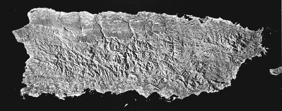
The above image was hand mosaicked and airbrushed at the EROS Data Center, then photographed by Dann Blackwood, Woods Hole Field Center). The larger composites were digitally mosaicked by Peter Briere, Woods Hole Field Center. View and/or download the individual SLAR images that make up this composite mosaic Side-looking airborne radar (SLAR) images are acquired by sending a beam of radar energy to the ground at an angle perpendicular to the aircraft’s flight path (http://edcwww.cr.usgs.gov/glis/hyper/guide/slar). Unlike visible and near-infrared wavelengths, radar energy (at the correct wavelength) can penetrate most clouds, making it an especially useful tool in Puerto Rico where a persistent cloud cover generally obscures parts of the island. With SLAR the terrain is illuminated at an oblique angle to enhance subtle geologic structures such as folds and faults. Light and dark areas on the image are caused by high and low radar reflectivity, respectively. The size of objects discerned from SLAR depends upon the radar return, so the azimuth resolution of 10-15 meters is not necessarily a limiting factor. The SLAR image of Puerto Rico was captured at a flight altitude of 8,230 meters above mean sea level, on 46 km-wide strips flown along 20 km flight lines. Sections from the eleven image strips were mosaiked and photogrammetrically controlled to USGS 1:250,00-scale Universal Tranverse Mercator (UTM) topographic maps of Puerto Rico. |