|
||||||||
Fe-Mn Nodule Field Indicated by GLORIA, North of the Puerto Rico Trench Kathryn M. Scanlon1 and Douglas G. Masson2 |
||||||||
|
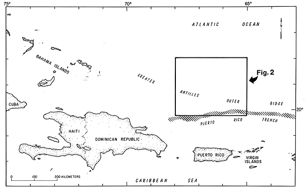
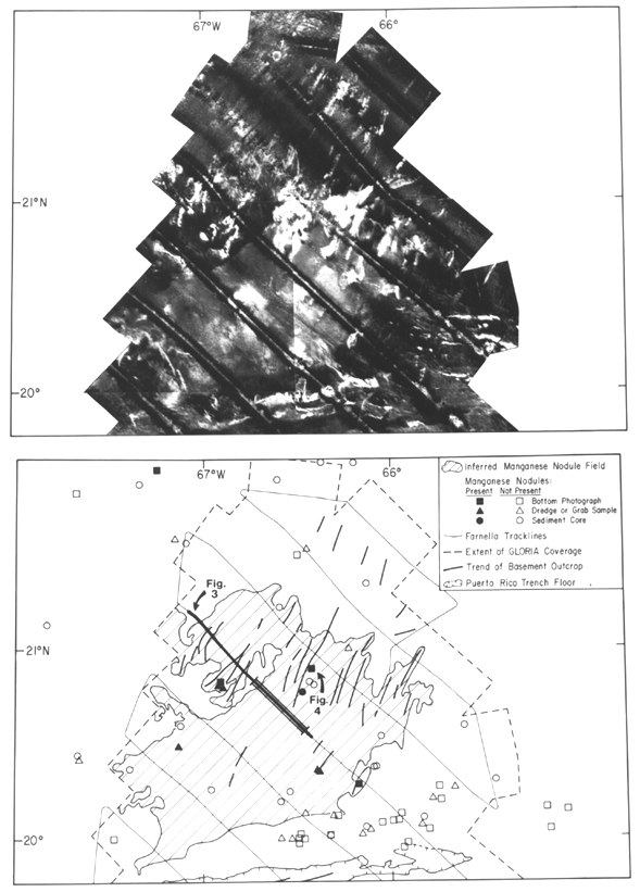
ABSTRACT INTRODUCTION The study area lies approximately 150-350 km north of the island of Puerto Rico, north of the Puerto Rico Trench (Fig. 1). Fe-Mn nodule occurrences have been reported from this region (e.g., Rawson and Ryan, 1978), but the extent of the nodule field was not previously known. DATA GLORIA is a long-range sidescan-sonar system designed and built at Great
Britain's Institute of Oceanographic Sciences for deep-ocean reconnaissance mapping.
Technical details on the GLORIA system can be found in Somers and others
(1978). The GLORIA images presented here have been processed and digitally mosaicked
using the USGS Mini Image Processing System (MIPS). Processing included a correction for
slant-range geometry, removal of distortions due to changes in the ship's speed, and
spectral corrections for noise and variations in signal strength. The data were then
mosaicked and appropriate spectral stretches were applied to enhance the images. Further
details regarding GLORIA processing procedures can be found in Chavez
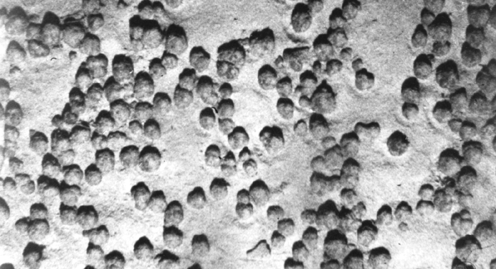
(1986) and EEZ-SCAN 85 Scientific Staff (1987). Note that areas of high acoustic backscatter show as bright areas on GLORIA images, whereas areas with low backscatter are dark. This is opposite to the convention used with most shorter-range sidescan-sonar systems. The intensity of backscatter is affected by several factors including water depth, sea floor morphology, bottom type (i.e., rock or sediment), and in the case of sedimentary sea floors, sediment composition and degree of consolidation. In addition, the presence of fields of bedforms and other types of seafloor roughness that, individually, are well below the resolution of the GLORIA system can often be inferred from changes in the intensity of backscatter over a large area (e.g., Kidd and others, 1985; Huggett and Somers, 1988). To aid in the interpretation of the GLORIA mosaic, additional data from the archives of the Woods Hole Oceanographic Institution and Lamont-Doherty Geological Observatory were used. These include core, grab sample and dredge descriptions, and bottom photographs (Fig. 2). GEOLOGIC SETTING Two distinct seismic facies are seen in the sediment cover: a stratified layer resting on acoustic basement and an overlying acoustically transparent layer (Fig. 3). The stratified layer appears to fill low areas between basement ridges. It consists of Middle Cretaceous through early Tertiary (middle Eocene) interbedded limestone, chert, and consolidated and unconsolidated silt, clay, and ooze and is separated from the overlying transparent layer by the middle Eocene Horizon A (Tucholke and Ewing, 1974). The transparent layer is composed of terrigenous sediment deposited by the Western Boundary Undercurrent (flowing south and east) where it interacts with the Antarctic Bottom Water (flowing north and west). The resulting sediment drift, the Greater Antilles Outer Ridge (GAOR), crosses and extends beyond the study area in an approximately 100-km-wide band for more than 300 km to the northwest and also several hundred kilometers eastward (Tucholke and Ewing, 1974). Within the study area, the GAOR is thickest in the north and thins southward (Fig. 3). The depositional history of the Greater Antilles Outer Ridge has been discussed in detail elsewhere (Tucholke and others, 1973; Tucholke, 1974; Tucholke and Ewing, 1974; Tucholke, 1975). INTERPRETATION The difference in acoustic reflectivity between pelagic sediments and Fe-Mn nodules has been shown by Huggett and Somers (1988) to be great enough to create a mappable difference in backscatter in GLORIA data. Their study is based on the acoustic scattering effects of a 10% coverage of the seafloor by nodules. We have bottom photographs from only three sites within the bright area; these show nodule coverage of between 5% and 25%. Compressional wave velocity in the transparent layer sediment (1.50 to 1.77 km/s according to Savit and others, 1964) is comparable to the velocity used by Huggett and Somers (1988) (1.52 km/s). It is therefore reasonable to apply Huggett and Somers' (1988) conclusions to our study area. The presence of Fe-Mn nodules is consistent with the area's low sedimentation rate as inferred from the thinness of the transparent layer. DISCUSSION AND CONCLUSIONS First, we considered possible topographic effects. The area of high backscatter lies on the flank of the Greater Antilles Outer Ridge. However, it produces the same level of backscatter whether insonified from upslope or downslope, indicating that the slope of the sea floor is not causing the difference in backscatter. Second, we considered whether a strong seismic reflector, such as Horizon A, were exposed at the sea floor, and evaluated whether GLORIA could be penetrating the sea floor and recording backscatter from a buried horizon. Horizon A is exposed (or lies very near the surface) in the southern part of the bright area. However, the transparent layer covers Horizon A in the northern part of the bright area (figure 3), eliminating the possibility that the high backscatter could be caused by exposure of Horizon A or the deeper stratified layer. Although the GLORIA signal can penetrate a thin layer of sediment, the transparent layer is over 50 m thick in parts of the bright area (figure 3). Huggett and Somers (1988) calculated that 10 m of pelagic ooze would effectively mask an underlying horizon. We therefore feel confident that GLORIA is not penetrating the transparent layer and that the bright area is not caused by a buried reflector such as Horizon A or the stratified layer. Third, there is the possibility that a covariant, some characteristic of the seafloor that exists in the bright area with the nodules, may cause the difference in backscatter. Because the Greater Antilles Outer Ridge is a current-deposited sediment body, and because Fe-Mn nodules form in areas of low sedimentation rates or current scour, the most likely covariants would be current-related surface features such as sandwaves or winnowed sediment. Bottom photographs from two of the three locations shown in Figure 2, however, do not show evidence of currents. One shows evidence of biological activity (burrows and trails), which would not be expected to persist in an area swept by currents. We therefore suggest that a covariant is not likely to cause the difference in backscatter. The samples and photographs used to support our interpretation of the GLORIA data were collected by others for other purposes and are not ideally suited to prove our hypothesis. They do, however, provide circumstantial evidence that a field of Fe-Mn nodules is causing the anomalously high backscatter in the study area. Deep-towed camera transects across the boundary between high and low backscatter would provide more conclusive evidence. A good place for such a transect would be in the vicinity of the seismic profile shown in Figure 3, where the boundary is particularly sharp. Our data suggest that the extent of a Fe-Mn nodule field can be mapped in a relatively short time using GLORIA long-range sidescan. This type of mapping with GLORIA is not limited to Fe-Mn nodules, but can be applied to any sediment facies on the deep sea floor that provides sufficient acoustic contrast with the surrounding sea floor (e.g., Kidd and others, 1985). Although additional data, such as bottom photographs, are needed to verify the cause of backscatter differences and higher resolution sidescan and sampling studies are necessary to more accurately determine the economic value of a deposit, this study indicates that a reconnaissance program using GLORIA data could greatly reduce the time needed for such studies. Acknowledgments Chavez, P.S., Jr., 1986. Processing techniques for
digital sonar images from GLORIA. EEZ-SCAN 85 Scientific Staff, 1987. Atlas of the U.S.
Exclusive Economic Zone, Eastern Huggett, Q.J., and Somers, M.L., 1988. Possibilities
of using the GLORIA system for manganese Kidd, R.B., Simm, R.W., and Searle, R.C., 1985. Sonar
acoustic facies and sediment distribution Klitgord, K.D., and Schouten, H., 1986. Plate
kinematics of the central Atlantic. In: Vogt, P.R., Masson, D.G., and Scanlon, K.M., 1991. The
neotectonic setting of Puerto Rico. Geological Rawson, M.D., and Ryan, W.B.F., 1978. Ocean floor
sediment and polymetallic nodules. Savit, C.H., Knox, W.A., Blue, D.M., and Paitson, L.,
1964. Reflection and velocity profiles Scanlon, K.M., Masson, D.G., and Rodriguez, R.W.,
1988. GLORIA sidescan-sonar survey Somers, M.L., Carson, R.M., Revie, J.A., Edge, R.H.,
Barrow, B.J., and Andrews, A.G., 1978. Tucholke, B.E., 1974. The history of sedimentation
and abyssal circulation on the Greater Antilles Tucholke, B.E., 1975. Sediment distribution and
deposition by the Western Boundary Tucholke, B.E., and Ewing, J.I., 1974. Bathymetry
and sediment geometry of the Greater Antilles Tucholke, B.E., Wright, W.R., and Hollister, C.D., 1973. Abyssal
circulation over the Greater FIGURE CAPTIONS
|