|
ABSTRACT
The San Juan Metropolitan Area (SJMA) was selected for case study as part of an
investigation of "Earth-surface processes, materials use, and urban development:
understanding the human contributions to global geomorphological change" (ESPROMUD).
The ESPROMUD investigation, commissioned by the Scientific Committee on Problems of the
Environment (SCOPE), has the goal of evaluating and understanding the effects of
urbanization and resource extraction on earth-surface processes.
Puerto Rico, a partially closed system (oceanic island) relative to water and mineral
resources, and its capital city, San Juan, are struggling to meet the demands for water,
building materials, and infrastructure development by an expanding population and
unchecked urbanization. The SJMA case study suggests a need for long-term, inventory-based
policies and practices regarding the use and conservation of natural resources to avoid
shortages of water and building supplies for housing and infrastructure expansion.
Resource inventories, both in proximity to the SJMA and island-wide, must be evaluated
relative to projected demand in order to achieve realistic constraints for a stable urban
economy and healthy ecosystems.
INTRODUCTION
In recent decades, stresses imposed by human activities on global systems have emerged
as concerns to planners, earth scientists, environmental managers, and citizens. Since
glacial times, land-surface changes often have been dominated by human activities,
particularly agriculture. In addition to deforestation, land degradation, and soil erosion
associated with farming, major transformations of landscapes and of fluvial and coastal
systems continue to occur in areas of human settlements and mineral extraction. The
environmental effects of urbanization and related activities of mining, quarrying, and
infrastructure development are principal factors promoting anthropogenic change in the
nature and processes of the earth’s surface.
The ESPROMUD (earth-surface processes, materials use, and urban development:
understanding the human contribution to global geomorphological change) project is part of
the Global Changes cluster within the scientific program of SCOPE -- the Scientific
Committee on Problems of the Environment -- and is designed to evaluate the effects of
urbanization and extractive industries on earth-surface processes. An objective of the
ESPROMUD activity is to compile and evaluate available information regarding these effects
and thus to identify gaps in the understanding of the impacts. The Río Grande de Loíza
Basin/San Juan, Puerto Rico, exemplifies problems related to urban expansion and was
selected for this pilot study.
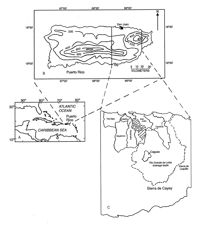
Puerto Rico is an island far enough removed from other land areas that importation of
water and rock resources is impractical (fig. 1A). The
island (fig. 1B) can be viewed as a partially closed
system relative to availability of resources for urban development, and therefore the
difficulties of accommodating the needs of an expanding population may be more easily
recognized than they are elsewhere. Moreover, the San Juan metropolitan area (SJMA) is
typical of large cities worldwide by (1) having a coastal setting of fragile, near-shore
ecosystems vulnerable to the stresses of human development, (2) being dependent on inland
water and rock resources of nearby drainage basins, and (3) experiencing an urban growth
rate greater than the regional rate.
The 802-km2 (square kilometer) Loíza drainage basin, the largest of Puerto
Rico, and the adjacent 67-km2 Río Piedras Basin were selected to analyze the
effects that growth of the capital city, San Juan, has had on these rivers and the coastal
zone into which they discharge (fig. 1C). The growth
was intensified after 1953 by the construction of Carraizo Dam on the Río Grande de
Loíza, thereby increasing the potential supply of municipal water by impounding
streamflow in Loíza Reservoir (or Lago Loíza). The dam and reservoir originally were
intended for the generation of hydroelectricity, but storage of water and extractions to
satisfy as much as 58 percent of the metropolitan needs of the San Juan area (Fields,
1972) quickly stopped the generation of electricity. The use of Loíza Reservoir, which
collects runoff and sediment from the upper 540 km2 of the basin, as a storage facility
for a municipal water supply was also complicated by sedimentation resulting in a
13-percent reduction in storage during the first 10 years and a 47-percent reduction in
1994 (Webb and Soler-López, 1997). Urbanization was stimulated also, mostly in the 1960s,
by ground-water development in support of industrial expansion. The ground-water resources
were recovered from karstic limestone that occurs in near-coast areas of Puerto Rico.
Increased land degradation and alteration of the drainage network prompted accelerated
erosion and rapid sedimentation in the reservoir and the release of solid wastes and
chemical contaminants to the surface- and ground-water systems. Thus, the effects of
urbanization and resource development now are impeding further development of land and
water resources. The Loíza Basin, a principal source of rock and water for many Puerto
Ricans, has had (1) a high rate of urban expansion in recent decades, (2) active quarrying
of building stone and excavation of sand and gravel to support population increase, and
(3) abundant documentation of the impacts that urbanization has exerted on the fluvial and
coastal systems. These features make the Loíza Basin/San Juan area an instructive
case-study example.
CHARACTERISTICS OF PUERTO RICO AND THE RÍO GRANDE DE LOIZA AND RIO PIEDRAS
WATERSHEDS
Puerto Rico, an oval-shaped island, lies in the West Indies chain between Hispaniola
and the Virgin Islands. Centered at latitude 18d 15’ N, longitude 66d 30’ W,
Puerto Rico has an east-west length of 176 km (kilometers) and a north-south width of 56
km; the area is about 8780 km2. Population centers are mostly within 7 km of
the coast, a zone in which about 85 percent of the 3.8-million inhabitants live
(Rodriguez, 1994). A central mountain chain, the Cordillera Central, extends eastward
through much of Puerto Rico’s length and typically exceeds 600 m (meters) above sea
level (fig. 1B); peaks are as high as 1338 m. An
eastern segment, the Sierra de Cayey, forms part of the southern drainage divide of the
Loíza Basin, and western portions of the Sierra de Luquillo provide runoff to the eastern
part of the basin (fig. 1C).
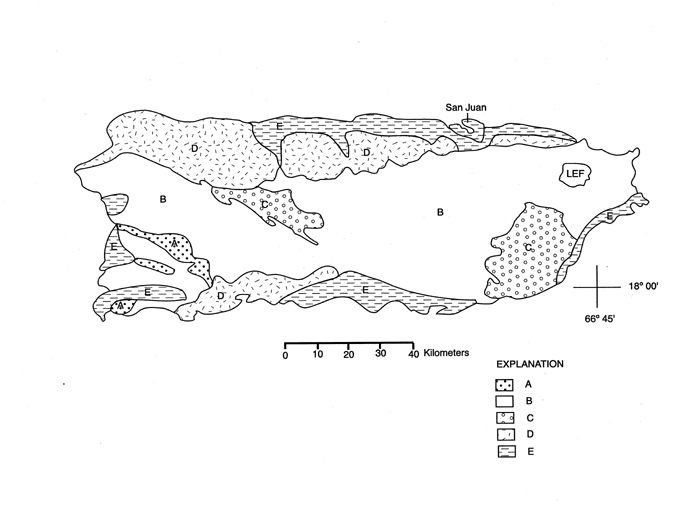
Physiography, Geology, and Soils
Major physiographic units of Puerto Rico, largely based on geology, are Upland,
Northern Karst, and Coastal Plain (Monroe, 1980). The upper four-fifths of the Loíza
Basin are in the mountainous Upland province, an erosional landscape of granodiorite and
volcaniclastic rocks of late Cretaceous and early Tertiary age (fig. 2, B and C). In the Piedras and lower Loíza Basins,
thick limestones with basal clastic beds of Tertiary age (fig.
2, D) unconformably overlie the fractured igneous rocks, and in some near-coast areas
are covered by a veneer of silt and sand (fig. 2, E). The clastic
and carbonate beds occur locally along the southern coast of Puerto Rico, but the
limestones that define the Northern Karst province are mostly exposed as a band, up to 23
km wide, along the northern coast west of the Piedras and Loíza Basins (Glover, 1971;
Monroe, 1980).
The Coastal Plain province consists predominantly of surficial material resting
unconformably on the older rocks. The sediment, mostly poorly consolidated Quaternary-aged
silt, sand, and gravel, is a variety of flood-plain, coastal-plain, and beach deposits (fig. 2, E). In the lower Loíza Basin, Coastal Plain
deposits generally blanket karstic limestone, thereby minimizing surficial expression of
the Northern Karst province.
Most soils of the Upland province are acidic, clay-rich, and highly erodible,
reflecting deep weathering of the volcanic rocks from which they are derived. The
southeastern Loíza Basin has loamy soils derived from weathered granitic rocks. Where
flood-plain, terrace, and coastal-plain sediment overlies volcanic or carbonate rocks of
the Loíza and Piedras Basins, soils are well drained and sandy. Detailed descriptions of
soil characteristics of the upper Loíza Basin were given by Hunt (1976), and Boccheciamp
(1978) mapped the soils of the San Juan area.
Climate
Puerto Rico has a tropical marine climate of average temperatures ranging from 20d C in
the mountains to 26d C in coastal areas (Picó, 1969). The central mountain range is a
barrier to northeast trade winds and casts a rain shadow over most of southern Puerto
Rico. Rainfall in the northern island averages about 2000 mm (millimeters) annually,
whereas southern areas average about 1100 mm (Calvesbert, 1970). Annual precipitation in
the Loíza Basin generally averages between 1570 and 1700 mm; the basin-wide mean is about
1600 mm but rainfall locally reaches about 2500 mm due to an orographic effect of the
mountains. San Juan, representative of the Río Piedras drainage basin, has a mean annual
precipitation of about 1530 mm.
Rain in Puerto Rico typically falls as short-duration showers of 5 to 10 mm throughout
the year, the 4-month period of August through November generally accounting for nearly
half of the annual total. Hurricanes and other tropical storms, such as Hurricane
Hortense, September, 1996, may yield as much as 70 percent of total rainfall for a year
during a one- or two-day period (Palm and Hodgson, 1993; Larsen, 1997).
Population, Land Use, and Economy
The population of Puerto Rico, presently about 3.8 million, rose 84 percent from about
1.9 million in 1940 to 3.5 million in 1990, and in the Loíza Basin population rose from
93,200 in 1971 (Hunt, 1976) to 350,000 in 1990. From 1950 to 1990 the population in the
Caguas area increased 460 percent, from about 34,000 to 191,000. About 1.22 million
people, mostly in the Río Piedras Basin, lived in the San Juan, Bayamón, Guaynabo, and
Carolina districts (fig. 1C) in 1990 (U. S. Department of Commerce,
1992). By 1984, 75 percent of the Piedras Basin was urban, and projections suggest that
the entire basin will be developed by the year 2000 (Gellis, 1991).
The rapid rise in Puerto Rico’s population, and that of the SJMA in particular, is
related to economic changes of recent decades. Through nearly 70 years following American
occupation in 1898, about three-fourths of Puerto Rico, including the Loíza Basin, was
cropland and pasture converted from forest. Sugar cane, pineapple, coffee, and tobacco
accounted for 31 percent of net income and 80 percent of exports in 1940 (Brockmann,
1952). In the 1950s, tax-exemption programs aided industry and manufacturing, such as
pharmaceutical companies, and by the mid-1960s northeastern Puerto Rico especially had
changed from an agrarian to an industrial economy. The shift caused abandonment of many
farms and thus re-conversion to a 35-percent forest cover by 1985 (Gellis and others,
1998). In the Upland and Northern Karst provinces, urbanization into adjacent woodlands or
renewed agriculture will be hampered by topography. Half of Puerto Rico has slopes greater
than 45 percent, which, if developed, would be unstable and highly susceptible to failure
and erosion (Cerame Vivas, 1989; Larsen and Torres-Sánchez, 1996; Larsen, 1997).
The changes in the economic base prompted migration to urban areas, especially San Juan
and Caguas (fig. 1C). By 1991, the Loíza Basin was 8
percent urban (Larsen and Torres-Sánchez, 1992), resulting in congestion in San Juan,
spillover into nearby towns, and decentralization of industry. In 1940, 70 percent of the
island’s population was rural as opposed to about 21 percent now. Furthermore, many
rural residents commute to city jobs so that few in northeastern Puerto Rico escape the
urban influence (Hunter and Arbona, 1995).
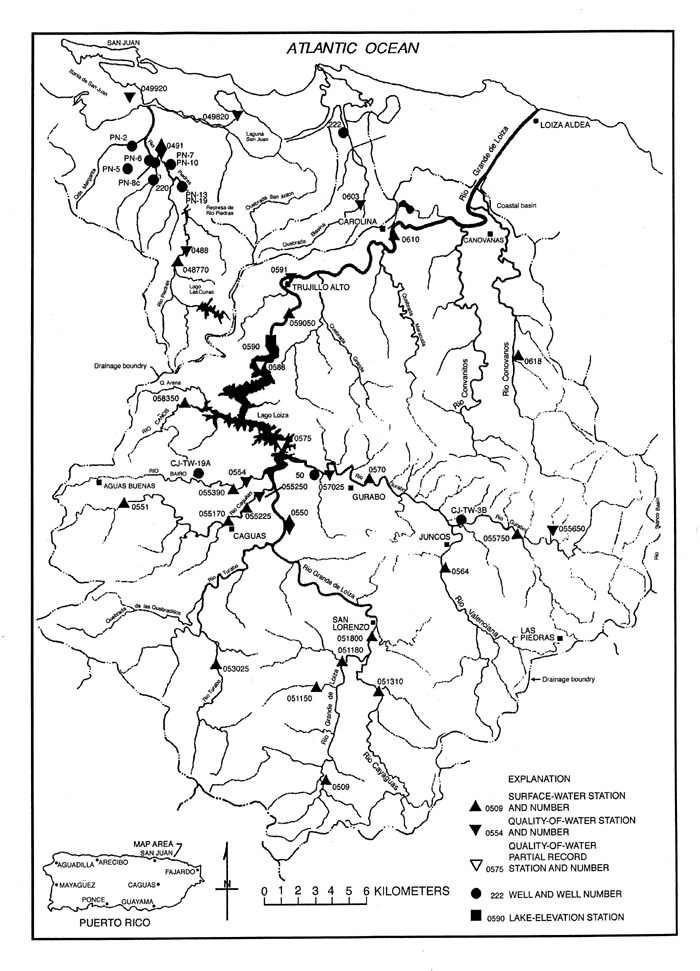
FLUVIAL SYSTEM, RIO GRANDE DE LOIZA AND RIO PIEDRAS
Puerto Rico is drained by streamflow except in the karst area, where much of the runoff
infiltrates and recharges limestone aquifers. The Río Grande de Loíza, which enters the
Atlantic Ocean about 10 km east of San Juan (fig. 3),
supplies much of the water for the SJMA. The less extensive and largely urbanized Río
Piedras Basin (figs. 1C; 3), immediately west of the Loíza Basin, contributes a small
proportion to the water needs of the SJMA. Data summarizing mean discharge, Q, in cubic
meters per second (m3/s), unit discharge, Qu, in cubic meters per second per square
kilometer (m3/s/km2), and sediment yield, in (metric) tons per square kilometer per year
(Qsy), are listed by U. S. Geological Survey (USGS) station number (Sta. No.) for gage
sites of the two basins in Table 1. Also given are station names and the drainage area
(DA) of each, in square kilometers. Instantaneous peak discharges (Qp) are provided for
selected gage sites.
Streamflow
Unit runoff from the Loíza and Piedras Basins, respectively, averages about 0.025 and
0.035 m3/s/km2 (table 1). Compared to average precipitation for
the two basins, these rates suggest that about 50 and 72 percent of rainfall,
respectively, results in streamflow in the two basins. The remainder of rainfall is mostly
lost to the atmosphere as evapotranspiration. The relatively high unit discharges of the
Piedras Basin are assumed to be caused in part by high runoff rates typical of urban
settings with extensive paved areas. Mean discharge into Loíza Reservoir is about 13 m3/s
and recent releases of water from Loíza reservoir have averaged about 6.4 m3/s (table 1,
number 15); the difference is mostly extractions averaging about 3.5 m3/s for municipal
water use (Gellis and others, 1998), infiltration, and evapotranspiration. Based on runoff
relations for non-urbanized areas of the Loíza Basin, mean discharge from the Piedras
Basin prior to urbanization was about 1.7 m3/s. Extrapolating recent discharge records for
the gage site Río Piedras at Hato Rey, PR (table 1, number 19), runoff to the ocean from
the Río Piedras Basin now averages about 2.3 m3/s. Thus, urban growth of the SJMA has,
through extractions for public water supplies, reduced streamflow in the Río Grande de
Loíza, but has increased flow in the Río Piedras through increased waste water
originating in the Loíza Basin, reduction of infiltration, and increased runoff from
paved areas.
Floods
Flooding in the Loíza and Piedras Basins can occur any time but is most likely during
the hurricane season. An exception occurred in January, 1992, when flooding was due to a
cold front combined with an upper-level trough (Torres-Sierra, 1996). Instantaneous peak
discharges of the last 36 years in the Loíza Basin at the Caguas, Juncos, Gurabo, and
Carolina gage sites (fig. 3; table
1, numbers 6, 12, 13, and 16) occurred during Hurricane Donna on September 6, 1960.
Peak discharges during a hurricane of August 4, 1945, probably exceeded those of 1960 at
many sites in the Loíza Basin, but accurate records are not available (Fields, 1972).
Other peak discharges listed in Table 1, for numbers 1, 4, 5, 6, 7, 9, and 10, occurred
during the frontal storm of January 6, 1992 (Torres-Sierra, 1996). Estimates of peak
discharges of September, 1996, during Hurricane Hortense suggest that most flows did not
exceed those of a return period of 50 years (Torres-Sierra, 1997).
Streamflow records at the Río Piedras at Hato Rey gaging station (table 1, number 19)
began in 1970 and indicate a peak discharge on June 17 of that year. For the period 1960
through 1993, 49 and 57 percent of the floods, respectively, at the Caguas and Gurabo gage
sites occurred during the August through November period (Gellis and others, 1998).
Mean discharges for 18 gaging stations and instantaneous peak discharges for ten gaging
stations are given in Table 1; at several sites, numbers 4, 5,
7, 9, 10, and 16, the period of record is short and poorly representative (at number 16,
mean discharge is unavailable owing to tidal conditions of measurement). Nevertheless, at
eight sites of the Loíza Basin, the peak discharge ranged from about 160 to 1050 times
mean discharge; peak discharge for a 26-year period at the Río Piedras at the Hato Rey
site (number 19) was about 170 times mean discharge. This measure of discharge variability
signifies the flashy streamflows that are typical of areas in the tropics that are subject
to intense storms and hurricanes.
Sediment Yield
Sampling for suspended sediment at two gage sites in the Loíza Basin began in 1984,
and therefore undisturbed conditions are not represented. Sediment yields in the Loíza
and Piedras Basins are listed in Table 1 for 18 sampling sites.
Average annual yields for the Caguas and Gurabo sites, numbers 6 and 13 (table 1) are
given for the 1984 through 1994 water years. Most other sediment yields are for the 1991,
1992, and 1993 water years only, a period of slightly deficient runoff and sediment
discharge in Puerto Rico (Gellis, 1991; Gellis and others, 1998). Sediment yields for Río
Cayaguas (no. 3) and Río Canóvanas (no. 17) are for the 1991 through 1995 water years
(Larsen, 1997).
Sediment-transport curves developed by Gellis and others (1998) and Larsen (1997) show
that 80 percent or more of sediment moved by the Río Grande de Loíza typically occurs
naturally during the several days each year of highest streamflow. The anomalously high
sediment yield measured in Río Piedras Basin at El Seńorial (table
1, number 18) is for 1988 and 1989, when active housing construction accounted for
about 6 percent of the basin area (Gellis and others, 1998). Number 19 (table 1) refers to
a very small watershed of a construction area and also illustrates the erosion and
sediment movement that are possible in northeastern Puerto Rico under disturbed conditions
(Gellis, 1991). Thus, the greatest potential for destructive erosion and large amounts of
sediment delivered to and deposited in Loíza Reservoir is when a hurricane or other
intense-rainfall event occurs in disturbed areas.
Sediment-yield data of Table 1 are too variable and not
numerous enough to show strong relations to high-intensity storms or land disturbance,
particularly because comparative data from relatively pristine drainage basins are sparse.
In the now undisturbed Luquillo Experimental Forest (fig.
2), which borders part of the Loíza Basin to the east, the sediment yield, 1991
through 1995 water years, from a 3.3-km2 watershed of the upper Icacos River
was 525 tons/km2/yr. In a 17.8-km2 watershed of the Mameyes River,
which flows northward from the experimental forest, the sediment yield was 117 tons/km2/yr
(Larsen, 1997). Compared to sediment yields of the Río Grande de Loíza, from watersheds
of similar size, these yields may not be high. Relative to yields from basins in other
tropical areas, the sediment yields of the Icacos and Mameyes Rivers are high and possibly
reflect the effects of landslide disturbance along road corridors and of recent hurricanes
(Larsen, 1997; Larsen and Parks, 1997).
Using erosion-prediction technology (the Universal Soil Loss Equation), Molinelli
(1982) estimated soil loss in the Loíza Basin for forested, pasture, cropland, and
construction areas, respectively, to be 1950, 2490, 7750, and 7870 t/km2/yr.
Gellis and others (1996) measured sediment discharges from small plots at construction
sites that yielded sediment averaging about 30 to 40 times that of forest and pasture
sites and 10 times that of croplands. These estimates, which are partly supported by data
of Table 1, are useful for distinguishing variation in sediment
yield with land use, but do not account for sediment entrained by overland flow and later
stored at the bases of hillslopes or on bottomland surfaces. Hence, measured sediment
yields are generally lower than estimates of erosion rates. The estimates suggest that
sediment yields of the last century in the Loíza Basin may have been greatest prior to
1950, when farming dominated land use. Sediment yields during the last 30 years possibly
decreased as farms were abandoned and the lands reverted to forest. As development related
to the urban areas of San Juan and Caguas continues in the Loíza Basin, accelerated
sediment discharge from construction sites may in turn accelerate the sedimentation rate
in Loíza Reservoir and thereby further threaten the water supply that has facilitated
urbanization.
Water Quality
Due to a generally granitic/volcanic geology and moist climate, dissolved-solids
concentrations in runoff of northeastern Puerto Rico are typically less than 300 mg/l
(milligrams per liter); pH values of streamflow are consistently in the range of 7.0 to
7.9 (Díaz and others, 1995). Concentrations of specific dissolved constituents generally
do not exceed health-standard limits, but locally and for short durations the
concentrations of constituents such as manganese, iron, and various organic compounds may
exceed recommended limits (Díaz and others, 1995). Where ground-water inputs to streams
have been contaminated by municipal landfills, hazardous-waste dump sites, and various
illegal disposal sites, streamflow may be highly contaminated with mercury and other heavy
metals, solvents, and pesticides (Hunter and Arbona, 1995).
High concentrations of fecal-coliform (FC) and fecal-streptococci (FS) bacteria are a
major surface-water quality concern throughout Puerto Rico, but the problem is most acute
in streams draining urban areas, industrial parks, and suburban communities lacking sewage
systems. As noted by Hunter and Arbona (1995, p. 1336), the combined processes of
urbanization and industrial growth have "been so rapid as to create a serious lag in
the provision of infrastructure services; unauthorized domestic hookups always exceed
already-saturated plant capacities. Thus at the majority of sewage facilities, the supply
of human waste outstrips treatment capacity and raw sewage is consequently discharged into
streams. The risk to human health is obvious."
Díaz and others (1995) found that the highest concentrations of FC and FS in surface
waters of Puerto Rico generally occur in streams draining densely populated and
industrialized areas of the island. In 1994 the highest levels of surface-water
contamination by FC and FS occurred at sites in the SJMA. At the Quebrada Blasina near
Carolina, PR, water-quality sampling site (fig. 3,
number 0603), in the eastern San Juan area, for example, concentrations of FC and FS in
water samples collected during the 1994 water year were as great as 530,000 and 120,000
colonies per 100 milliliters, respectively. Similarly, at the Río Piedras at Hato Rey
(fig. 3, number 0491; table 1, number 19), water-sample concentrations of FC in 1994
varied from 37,000 to 600,000, and FS ranged from 7,200 to 730,000. These concentrations
compare to a standard maximum microbiological-contaminant level of 1000 colonies FC per
100 milliliters for raw recreational water in the United States (Hunter and Arbona, 1995).
In addition to receiving wastes in runoff from the metropolitan area, streams of San
Juan also receive waste-laden effluent from sewage-treatment plants and untreated sources
in the upper parts of the Loíza and Piedras drainage basins. Elsewhere in Puerto Rico,
the main sources of contamination in surface-water systems are liquid wastes from
industrial and municipal sources (Díaz and others, 1995).
ENVIRONMENTAL ISSUES OF THE LOIZA BASIN
Puerto Rico is susceptible to earthquakes, tsunamis, hurricanes and coastal floods,
riverine flooding, landslides, and subsidence (Palm and Hodgson, 1993); natural hazards
are exacerbated by urbanization. Water pollution, accumulation of solid wastes, and
erosion accelerated by development, all direct consequences of urban growth, however, may
be of greater economic and social significance than are natural hazards. Cerame Vivas
(1989, p. 109) commented that the "main ecological problem of Puerto Rico by the year
2000 will be population. All of the environmental problems that we confront emanate from
our overpopulation."
Natural Hazards
Puerto Rico is near the subduction zone and boundary of the North American and
Caribbean tectonic plates and thus is susceptible to large earthquakes and tsunamis (Hays
and Gori, 1984). In 1918 a magnitude-7.5 earthquake destroyed many buildings on
stream-valley alluvium and coastal-plain sediment and was accompanied by a tsunami on the
west coast (Reid and Taber, 1919). Parts of Puerto Rico most subject to damage by
earthquakes and tsunamis are coastal and flood-plain areas of Río de Bayamón (in the Toa
Baja, Catańo, and Bayamón districts, fig. 1C), Río
Piedras, and Río Grande de Loíza, where urban expansion has been most intense
(Molinelli, 1987).
Hurricanes are common in Puerto Rico and other coastal areas of the Caribbean region
where they cause storm surge, high wind and rainfall, tornadoes, and flooding. Storm surge
(a rapid rise in sea level) is the main danger to coastal population centers of Puerto
Rico and accounts for a large majority of hurricane-related deaths (Pielke, 1990, p. 59).
Storm surge of hurricanes and other tropical storms also causes coastal and bottomland
flooding. Effects of high wind and heavy rain, as much as 400 mm in a day, include
extensive erosion, flooding, and plant-biomass reduction (Scatena and others, 1993).
The most recent major storm to affect Puerto Rico was Hurricane Hortense, September 9
and 10, 1996, which yielded up to 600 mm of rain in the Sierra de Luquillo (fig. 1C) and generally in excess of 400 mm throughout the
rest of eastern Puerto Rico (Torres-Sierra, 1997). Flooding was extensive along the Río
Grande de Loíza and other streams draining northeastern Puerto Rico, causing major damage
to urban areas and coastal-plain infrastructure. In some urban areas the flooding and
resulting property damage were compounded by inadequate or clogged drainage systems.
Channel alterations in the Loíza Basin included scour, aggradation, and widening.
Estimates suggested that storm-related sediment loads in the Loíza Basin, partly due to
numerous debris flows, soil slips, and landslides, equaled the mean annual sediment yield.
Much of the sediment was deposited in Loíza Reservoir, further reducing its storage
capacity. Damage to forests was minor, but crop damage was extensive. Power and water were
disrupted to nearly all of Puerto Rico, and damage to streets, highways, and distribution
systems for food and water was also substantial. Coastal-plain flooding caused only
limited damage to the San Juan municipal landfill, but movement of solid and toxic wastes
to the fluvial network from other landfill sites may have been extensive (M. C. Larsen,
USGS, written commun., 1996; F. N. Scatena, USDA Forest Service, oral commun., 1996).
Hazards Aggravated by Urban Development
Deep weathering and soil development in eastern Puerto Rico causes steep, unstable
slopes that are vulnerable to mass movement, especially when induced by heavy rainfall and
treefall. Hurricane Hugo, with rainfalls exceeding 200 mm in September, 1989, triggered
numerous landslides; 71 percent of the landslides that occurred during and shortly
following the hurricane in the Sierra de Luquillo were also related to road construction
(Larsen and Torres-Sánchez, 1992). Landslide activity was absent in the Loíza Basin,
immediately to the west, where rainfall did not exceed 200 mm (Larsen and Torres-Sánchez,
1992). Hundreds of landslides, however, were triggered by Hurricane Hortense in the upper
Loíza Basin (M. C. Larsen, USGS, written commun., 1996). Road construction and related
urban disturbances strongly increase sediment yield through mass-movement processes as
well as by normal hillslope and fluvial erosion (Molinelli, 1984; Larsen and Parks, 1997).
Dissolution of limestone by ground-water circulation occurs naturally in the Northern
Karst province, resulting in caverns and sinkholes. In urban areas of Puerto Rico these
processes are enhanced by fracturing induced during earthquake activity, and collapse may
be induced where ground-water withdrawals or drainage of wetlands reduce pore pressures in
the aquifer. The imposed weight of large buildings, highway structures, and artificial
fill can be sufficient to cause bedrock failure in karstic areas (Griggs and Gilchrist,
1983).
Sediment is volumetrically the biggest contaminant of water in Puerto Rico. Sediment
increases water turbidity of reservoirs and lakes, which degrades water for consumptive
use, fouls water-distribution networks, and destroys aquatic habitat. Riverine
sedimentation decreases the runoff capacity and affects flood frequency, fills navigable
channels, and reduces soil fertility on agricultural land. Sedimentation in reservoirs
throughout Puerto Rico is reducing storage capacity and water availability (Molinelli,
1982; Webb and Soler-López, 1997).
Environmental Effects of Urbanization
Among the inevitable by-products of urban expansion are loss of wildlife habitat,
solute loading of water supplies, air pollution, soil loss, and the generation of solid
and toxic wastes. As previously noted, pollution of surface and ground waters in the
Loíza and Piedras Basins is in some cases extreme, and accelerated erosion due to soil
disturbance adversely affects agricultural production, generation of hydropower, and
public water supplies. In the San Juan area, environmental degradation due to air
pollution is minimized by strong trade winds and consequently is probably less intense
than for most urban areas of the world (Calvesbert, 1970).
Besides the impact on water resources, the most problematic environmental effect of
urbanization in Puerto Rico may be the handling of solid wastes, including toxic
substances. The population of 3.8 million, about 430 persons/km2, generates a
daily average of about 5000 tons of solid waste, one of the highest amounts, per capita,
in the United States (Hunter and Arbona, 1995). Almost all of these wastes are derived
from imported foods, raw materials, and manufactured goods, and about a third, by weight,
mostly metals, glass, plastics, and some wood products, is not readily subject to
biodegradation (Cerame Vivas, 1989).
Thirty of 61 landfills in Puerto Rico, including the San Juan landfill, will be full
within 4 years and nearly two-thirds may be unusable within 10 years. The San Juan
landfill, in an urban marsh, receives about 1000 tons of solid waste daily and has reached
its legal height limit of 22 m; a section of the city’s main water-supply pipe
underlies the landfill, causing concerns of contamination by toxic leachates (Hunter and
Arbona, 1995). At least 14 dumps, two of which are Superfund sites (Cerame Vivas, 1989),
containing hazardous waste are in the Loíza Basin; materials in the dumps are not well
documented but probably include pharmaceutical chemicals, petrochemicals, and wastes from
paint production and the apparel industry (Hunter and Arbona, 1995).
The area of Puerto Rico and its distance from other potential disposal or recycling
sites, the population density, and an undeveloped recycling capability combine to cause a
steady increase of solid wastes. Assuming a 1989 cost of $60 per person/year to handle and
dispose of wastes, the annual cost, adjusted for inflation, for refuse management by the
year 2000 may approach $1 million per day (Cerame Vivas, 1989). Much of this expense will
be borne by the SJMA, and does not include the disposal of presently stored wastes in
landfills of the Loíza Basin.
IMPACTS OF QUARRYING AND MINING, LOIZA AND PIEDRAS BASINS
Historic mining activity in Puerto Rico has included the extraction of lime for cement
but started with the mining of gold placers by Spanish settlers and the development of
iron and copper deposits (Cardona, 1984). In the Loíza Basin, known metalliferous
deposits are limited to lenses of magnetite in beach sands (Monroe, 1977) and small
amounts of copper, molybdenum, gold, and silver associated with sulfide minerals
disseminated in quartz diorite and volcanic rocks or concentrated along shear zones
(Pease, 1968). Potential metallic ores in the Loíza Basin may include iron and copper
skarns and copper or copper-gold bearing porphyries (Orris and others, 1992). The only
significant recent extractions of metal ores in the Río Grande de Loíza Basin have been
at the Keystone iron-skarn and Island Queen copper-skarn mines near Juncos, in the
southeastern part of the basin (fig. 3). About 8 km
apart, the two mines yielded a total of about 200,000 tons of ore in 1951 through 1953.
Assuming a weight of 2 tons/m3, the extracted ore amounted to about 100,000 m3, and a
similar volume of deposited wastes (Hooke, 1994).
Most quarrying in Puerto Rico presently is related to the production of cement and
concrete, and is nearly restricted to industrial (non-metallic) minerals, limestone,
volcanic rocks, and sand from weathered igneous-intrusive rocks. Continuing urbanization
and conversion to an economy based on tourism and industry depend on the availability of
construction materials. Especially during a construction boom of the 1950s and early
1960s, alluvial deposits along the Río Grande de Loíza and elsewhere (including beaches)
were extensively mined (Rodriguez, 1994). Downstream from Loíza Reservoir and along the
lower reaches of the Río Guaynabo (in the Río Bayamón Basin) and the Río Piedras,
large volumes of sand and gravel were taken from steadily expanding pits dug into alluvium
of the bottomlands; an analysis of 1990 aerial photography showed 64 sand and gravel pits
in the basin (Gellis and others, 1998).
By 1969, when the estimated rate of extraction of sand and gravel from the channels and
flood plains of the Río Grande de Loíza stream network was 51,500 m3/month, channel
deposits were nearly depleted and operations were shifting to alluvial-terrace sources
(Hunt, 1976). Despite claims only 2 decades ago of "virtually unlimited supplies of
sand and gravel" from alluvium of the lower Loíza Basin (Monroe, 1977), the onshore
resource of Puerto Rico has been essentially depleted, and increasingly the coastal and
offshore supplies are being developed; projections suggest that terrestrial sources of
sand and gravel will be exhausted by the year 2000. Results have been inadequate supplies
of coarse fluvial sediment to replace the bottomland and coastal-zone losses, beach
erosion, and environmental degradation that is proving harmful to the tourist-based
economy (Rodriguez, 1994).
The depletion of sand and gravel resources has led to the development of alternative
sources of building materials. Crushed stone is mined from large open-pit quarries in
unweathered volcaniclastic rocks near Loíza Reservoir, and sand is extracted from highly
weathered granodiorite in the vicinity of San Lorenzo (fig.
3). An inevitable consequence of mining sand from saprolitic horizons of the
granodiorite is release of fine sediment to the upper Río Grande de Loíza and thus to
Loíza Reservoir. In lower parts of the Loíza Basin, limestone of the Northern Karst
province yields construction stone. The limestone, however, is also a principal source of
ground water in near-coast areas, and quarrying of the limestone has reduced ground-water
availability and the potential for urban and industrial development.
Availability of industrial minerals has been essential to the growth and development of
Puerto Rico. Data from the Puerto Rican Department of Natural Resources indicate that the
material moved from sand and gravel pits and rock quarries active in 1996 ranged between
100 and 3000 m3/day/pit and averaged a total of about 17,000 m3/day.
Assuming a mean density of 2 tons/m3 and 250 working days per year, about
34,000 tons of material were moved daily and about 8 x 10⁶ tons, or 4 x 10⁶ m3,
are extracted annually. Dividing these estimates by the population of the SJMA,
approaching 1.3 x 10⁶, suggests an annual per-capita consumption of industrial minerals of
6 tons, or 3 m3, about a sixth that of the per-capita consumption in the United States (17
m3).
Most of the population growth of Puerto Rico presently occurs in the SJMA, and
therefore the major use of building and construction materials also occurs in the San Juan
area. If a mean thickness of 0.2 m of concrete, building stone, and other rock
construction materials is assumed for the San Juan area (K. G. Renard, Consulting
Engineer, oral commun., 1997), a total volume for the metropolitan area is roughly 1 x 10⁸
m3, or nearly 80 m3/person. Based on recent estimates of population
increases (U. S. Department of Commerce, 1992) and a population density approaching 3300
persons/km2, the annual increase in size of the SJMA is about 15 km2,
and the annual use of industrial minerals is about 4 x 10⁶ m3, the same volume,
estimated from records of the Department of Natural Resources, of sand, gravel, and rock
extracted annually from the Río Grande de Loíza Basin.
A 1992 mineral assessment (Orris and others, 1992) indicated that there were 19 active
quarrying sites and about 40 sites of previous activity in the Loíza Basin. Recent data,
acquired from the Puerto Rico Department of Natural Resources, list 29 active quarries in
the basin. In addition to sand (from weathered granodiorite) and limestone, current
extractions are crushed and broken rock of several kinds, volcanic aggregate, and
surficial "fill". The 1992 assessment indicated that other sources of
construction materials are calcareous clastic rocks, beach and swamp deposits, and
landslide and breccia areas. Marine volcaniclastic rocks are quarried at various sites in
the Loíza Basin.
Importation of industrial minerals to support construction has proven costly to
neighboring islands in the Caribbean region (Rodriguez, 1994). In contrast to most metals,
industrial minerals are rarely traded on the world market. Transportation costs of such
bulk materials require that they be obtained within reasonable proximity to the location
of their intended use. This economic aspect poses a particular burden for small island
nations with rapidly growing economies and populations. Governmental officials of Puerto
Rico are beginning to realize prospective limits to growth imposed by depletion of its
mineral-resource base.
URBAN GROWTH IN THE LOIZA AND PIEDRAS BASINS
The Río Piedras Basin is almost totally urban, and coastal-plain portions of the Río
Grande de Loíza Basin are rapidly approaching total urbanization. Presently, however,
about 8 percent of the Loíza Basin, mostly near the Atlantic coast, is urban, the
remainder, in the Upland and Northern Karst provinces having forest (about 21 percent),
agriculture and pasture (about 58 percent), and other rural land uses (about 11 percent)
(Gellis and others, 1998). Further urbanization of the Piedras Basin is not feasible, and
urban expansion in the Loíza Basin during the next few decades is likely to be
concentrated in presently suburban communities of the Coastal Plain province east of San
Juan and Carolina.
Table 2 lists projected water-use needs, relative to those of
1993, for the years 2000, 2020, and 2050; the projections were compiled by Ocasio (1996).
Entries for the San Juan metropolitan area (SJMA, table 2) are sums of anticipated needs
for the Bayamón, Canóvanas, Carolina, Catańo, Guaynabo, San Juan, Toa Baja, and
Trujillo Alto districts of the combined urban area. Residential water use, reflecting
expected population increase, is likely to increase the most from 1993 to 2050, an average
of 46.8 percent for all of Puerto Rico. Although some of the increase, 28.3 percent to
302,000 m3/day, will be in the SJMA, much of the remaining expected increase will be in
areas that become urbanized during the next half century. Like that of the Río Piedras
Basin, water use in the present SJMA cannot increase greatly because the area is already
almost totally developed. There is, however, significant potential for increased urban
growth and water use in parts of the Loíza Basin to the east of San Juan.
Presently available water resources are inadequate to accommodate significant increased
usage in the next 50 years by industry, whereas commercial use necessarily must increase
to support an expanding population. Projected total water needs will not increase as
strongly as will residential needs, in part because progressively smaller percentages of a
finite water resource will be used for other purposes (table 2).
If new technologies for water development, such as desalinization of sea water (Zack and
Larsen, 1993), are implemented (which, owing to cost, is unlikely in the near-term), water
use by the various components of the population and economy could increase significantly.
Although Puerto Rico is a water-rich island, present water demands during periods of
normal streamflow are approaching the capacity of those streams to supply water of
adequate quantity and quality. Recent drought conditions have demonstrated the precarious
nature of water availability and its distribution in Puerto Rico and to the SJMA. The New
York Times (June 22, 1997) reported that ".....Puerto Rico ordered water rationing in
San Juan and nearby areas last week because of low rainfall, heavy use of water, and
limited reservoir space. It is the second time that rationing has been ordered in three
years." The report continued that officials of the Puerto Rico Aqueduct and Sewer
Authority began ".....to shut off water service every other day in sections of San
Juan and nearby Carolina, Trujillo Alto, and Canóvanas. Government officials estimated
that about 500,000 people would be subject to the rationing." The water crisis
prompted statements by the governor, Pedro Rossello, that he would press for long-term
projects to remedy the problem, but the newspaper did not record how the projects might
alleviate water shortages or increase the available supply of water. Recently, a $1.8
billion program of the Puerto Rico Commonwealth was initiated to alleviate water shortages
through surface-water and ground-water extractions (M. C. Larsen, USGS, written commun.,
1998).
IMPACT OF URBANIZATION ON EARTH-SURFACE PROCESSES
The main changes to earth-surface processes by urbanization in the Río Grande de
Loíza and Río Piedras drainage basins have been land disturbance, erosion, sediment
transport (including the movement of contaminants adsorbed on sediment), and elimination
of slope-stabilizing vegetation. Landfills and dump sites contain materials susceptible to
fluvial transport during high-intensity storms, and quarries become sites of stored
sediment and generally have areas of bare surface vulnerable to erosion. Urbanization
creates impervious surfaces that yield high rates of runoff during rainfall, and thus
tends to increase flood peaks.
The impacts to surface processes by changes in sediment discharge and storage are self
evident and have been described in previous sections of this discussion. The consequences
of flashy streamflow include increased flooding, possible channel erosion, and flood-plain
deposition. The effects of these changes to biota are unclear, but the entrainment and
bottomland deposition of contaminated sediment certainly may be injurious to human health,
the food network, and agricultural productivity.
QUANTITATIVE CHANGE TO RIVER SYSTEMS
The main modification made to the channel network of the Río Grande de Loíza, was the
construction of Carraizo Dam in 1953 about 22 km upstream from the river mouth. Results
have been storage of water and sediment in Loíza Reservoir, channel scour downstream from
the dam, possible sedimentation in the lower reaches of the Río Grande de Loíza, and
interbasin diversion of streamflow to the San Juan area. Regulation of streamflow has
minimized flood peaks except at times of extreme events (such as Hurricane Hortense),
assured downstream water users of low-flow discharges during periods of drought, and
increased the potential for flooding through induced sedimentation in the lowest reaches
of the Loíza channel. Reduced flows below Loíza Reservoir, by decreasing channel
conveyance, have increased flood potential in densely-populated bottomlands along the
downstream reaches.
The original storage capacity of Loíza Reservoir was about 26.9 million m3,
and was increased to nearly 30 million m3 by flashboard additions in 1977, but
by 1995, due to sedimentation, had been reduced to about 14.2 million m3 (Webb
and Soler-López, 1997). In recent decades the reservoir has provided nearly 60 percent of
the water needs for the SJMA, but that percentage is likely to decrease as new engineering
approaches to import water to San Juan are implemented. Among these plans are the
development of a large aqueduct to San Juan from the western end of the island and
construction of water-supply dams and reservoirs upstream from Loíza Reservoir on the
Río Grande de Loíza at Quebrada Arenas, Río Cayaguas at Cerro Gordo, and Río
Valenciano upstream from Juncos (fig. 3).
Lago Las Curias, in a headwater part of the Piedras Basin, provides minor regulation of
Río Piedras streamflow, and all urban reaches of the lower Río Piedras have been
channelized or otherwise altered. A water-intake and water-treatment plant on the Río
Piedras provided the original source of municipal water for San Juan. Except during
periods of water shortage, these facilities are no longer used owing to pollution of the
Río Piedras (F. N. Scatena, USDA Forest Service, oral commun., 1996).
COASTAL PROCESSES AND TRANSFORMATIONS
Puerto Rico’s north coast at San Juan is a microtidal, storm-dominated area of
Quaternary alluvial and nearshore deposits overlying the Tertiary limestones of the
Northern Karst province. Where they remain, sandy pocket beaches, lagoons, mangrove
forests, and grass marshes protect inland coastal-plain areas from wave erosion.
Geomorphic features include coral reefs and eolianite and cuspate-beach ridges near the
mouths of Río Grande de Loíza and other major streams entering the Atlantic Ocean (Webb
and Morton, 1996).
Mangrove species concentrate fine sediment and organic matter in tidal-flat and
shallow-water lagoonal environments. The mangroves provide high species diversity of
marine fauna and flora, form habitat for native and migratory birds, help to buffer inland
areas from storm-surge and related wave-action processes, and provide recreational and
tourist income to the Puerto Rican economy.
Principal lagoons and estuaries of the San Juan area are Bahia de San Juan, Cańo de
San Antonio, Laguna del Condado, Laguna San José, Laguna La Torrecilla, and Laguna de
Pińones. These shallow-marine brackish-water bodies, prior to development, were generally
adjacent to and interactive with mangrove swamps. In large part their positions are
determined by coastal-zone outcrops of eolianite, ancient beach sand that is mildly
cemented by calcium carbonate. Fine sediment of the lagoons, and to a lesser degree of the
deeper Bahia de San Juan estuary, is subject to continuous reworking and resuspension by
tidal processes; thus, the lagoons appear to be partially self-cleaning. Sand spits and
other barrier islands do not occur along the north coast of Puerto Rico, probably because
shelf and coastal-plain areas are too narrow and the gradient from the island to deep
water of the Puerto Rico Trench is too great.
Under natural conditions, coastal sand dunes of northern Puerto Rico were at least as
high as 10 m above mean sea level and formed a band as wide as 160 m or more (Nichols and
others, 1987). The dunes provided a barrier between the Atlantic Ocean and the coastal
plain, offering protection from waves, flooding, and in particular storm surge related to
hurricanes and other tropical cyclones. In recent decades much of the protection provided
by the dunes has been eliminated by mining of the dune sand for a variety of purposes.
Near-shore coral reefs are extensive off the north coast of Puerto Rico, many being
within a few tens of meters of San Juan. Marine waters in proximity to the reefs support
abundant fish and crustaceans and are also important for recreation and tourism. Adding to
the protection afforded by mangrove swamps and sand dunes, the reefs form a breakwater
against wave erosion of beach deposits and provide a setting in which deposition augments
beach sand lost during hurricanes and by high-intensity storms. Where reefs adjacent to
coastal-plain areas of Puerto Rico have been destroyed by streams discharging large loads
of fine sediment and other contaminants, as much as 1 km of inland shoreline retreat has
occurred (M. C. Larsen, USGS, written commun., 1998).
QUANTIFICATION OF COASTAL CHANGE
Urbanization in the San Juan area of Puerto Rico has had measurable effects on coastal
dunes, tidal-zone stability, and lagoons. The effects of urban growth on marshes,
mangroves, and coral reefs are apparent but are difficult to quantify.
Mining of Coastal Sand
Following decades of sand mining along beaches of the north coast of Puerto Rico, few
natural dunes persist. Especially from the beach of Carolina, in the eastern part of the
SJMA, enormous quantities of sand were removed in the 1950s to construct the San Juan
airport. Within a few years accelerated beach erosion necessitated the construction of
artificial breakwaters to protect the tidal zone. Estimates of dune volumes for the north
coast of Puerto Rico decreased from 27 million m3 in 1950 to 16 million m3
in 1980 (Castillo and Cruz, 1980).
Where beach and coastal-plain sand of leeward areas separating shoreline dunes from
lagoonal mangrove forests has been removed, dune heights have been reduced as much as 12
m, and widths of foredune ridges have been narrowed to 8 m or less. Storm waves now easily
overtop the beach sand and breach the destabilized ridges that remain. Washover by
storm-wave swash has altered the ecological conditions of the mangroves by redepositing
sand in the mangroves, in some cases suffocating them. Repair to roads and other public
facilities in the SJMA is needed frequently after storm erosion and deposition of sand and
debris in low-lying areas. Annual erosion rates at a line of dunes along the shore at
Carolina, for example, over periods of 27 to 40 years, averaged 2.0 m (Nichols and others,
1987). When overtopping and dune-face erosion occurs, mixing of saltwater ponded in the
excavated lowland areas contaminates freshwater of the coastal-plain aquifer, continuing
shoreline retreat is likely, and buildings, marshes, mangrove forests, and other areas of
the tidal zone become vulnerable to damage or destruction (Zack, 1986; Nichols and others,
1987).
Various measures of protection, such as seawalls and revetments, have been employed
where erosion damage has been pronounced. A result has been a narrowing of the dry-beach
width for stabilized shorelines versus greater widths along destabilized shorelines
(Wright and Pilkey, 1991). Many sites of San Juan that are protected by seawalls, for
example, have no beach, and unprotected shorelines of Carolina, where sand has been
extracted, have narrow beaches that have been migrating inland and displacing mangrove
forests.
Dredging and Filling of Lagoons
All of the lagoons of the San Juan area except for Laguna de Pińones, which is
protected by mangrove forests, have been extensively modified by shoreline structures,
dredging of sand from the interior of the lagoon or channels entering it, filling in
shoreline areas, and construction of railroads, bridges, and buildings for housing and
commercial purposes. Laguna La Torrecilla, at the eastern end of the San Juan airport,
increased in volume by an estimated 110 percent due to dredging of about 3.1 million m3
of sand and silt from only 25 percent of the lagoon area. Later filling along the
shorelines reduced the area of the lagoon by about 10 percent. In places Laguna La
Torrecilla was deepened to as much as 18 m, whereas Laguna San José and Laguna del
Condada, both surrounded by urban area of San Juan, were deepened to about 11 m (Ellis,
1976). The dredging was accompanied by destruction of adjacent mangrove swamps to permit
the construction of hotels and marine clubs in the vicinities of the airport and the old
section of San Juan.
DISCUSSION
The social, economic, and environmental problems that have accompanied urban growth in
Puerto Rico are obvious. Solutions, too, are easily identified if only specific objectives
are considered, but remediation of an environmental problem may exacerbate a social or
economic problem.
Urbanization and Resource Availability
Water development, especially the construction and filling of Loíza Reservoir,
encouraged expanding urbanization, and incentives for drug industries provided jobs that
resulted both in massive contamination of surface-water and ground-water supplies and
population increases in the Río Grande de Loíza drainage basin. Construction of new
homes and businesses increased erosion and sedimentation in the reservoir. Erosion and
pollution that accompany urbanization, moreover, are seriously impairing the ability of
the reservoir to provide water of adequate quantity and quality.
Despite hazards such as landslides, hurricanes, and earthquakes, sedimentation is the
greatest threat to continuing water storage in Loíza Reservoir. As an expanding urban
population in Puerto Rico increases its dependence on stored water for domestic supplies
and power generation, the rate of reservoir sedimentation becomes pivotal to the social
and economic well being of the urban community (L’vovich and others, 1990). For any
reservoir, this rate is indicative of general basin conditions -- climate, geology and
soils, topography, vegetation, and especially land use. Reservoir sedimentation, however,
is also influenced by specifics such as rainfall intensity and distribution, tectonics,
fire frequency, and the extent to which soil erosion due to human disturbance is
minimized. The longevity of present and planned reservoirs in Puerto Rico, those in
support of urban growth, can be increased if presently available erosion technology and
land-use planning are applied in a thoughtful and conscientious manner.
Future discoveries of metallic-mineral resources in Puerto Rico, based on
identification of permissive geologic environments, could include various types of
deposits containing copper, gold, iron, zinc, lead, manganese, and molybdenum (Orris and
others, 1992). In the Loíza Basin in particular, porphyry copper-gold and copper-iron
skarn deposits were deemed permissive by the geologic setting and characteristics. Were
such deposits to be discovered and developed, additional demands and impacts on the
fluvial and ground-water systems would be anticipated.
Environmental impacts of mining sand, gravel, and other building materials extend
beyond the effects of development and denudation to modifications in stream regimen. Loss
of alluvial-terrace and flood-plain deposits has an adverse effect on agriculture and
other riparian-zone land uses. Alluvial barrow pits adjacent to river courses are subject
to flooding and piracy of the stream channel with obvious impact on river-bank property.
Perhaps most serious is the loss of sand and gravel for beach nourishment and
replenishment.
Assessment of the environmental costs of exploiting industrial minerals and sand and
gravel has been slow in Puerto Rico. The principal concern at present appears to be the
identification of additional resources for infrastructure development, with little effort
directed toward remedial work at active or abandoned quarry sites. Attention is being
directed toward the exploitation of lagoons and off-shore deposits of sand and gravel
(Rodriguez, 1994), which could create new environmental problems for coastal and
shallow-marine areas. Mitigation of the environmental impacts by regrading sites and
revegetation, as well as by restrictions in site development, would help to alleviate
continued erosion and reservoir siltation. Dredging of sediment from Loíza Reservoir is
planned to extend the useful life of the reservoir (Webb and Morton, 1996), an activity
that also may provide a small supply of sand and gravel relative to urban demand.
Problems related to mining and quarrying experienced in the Río Grande de Loíza
drainage basin are not unique. In many urban areas of the world, a supply of industrial
minerals at reasonable cost for continued urban growth is of increasing concern. In the
San Juan area of Puerto Rico, as elsewhere, the available resources that were unencumbered
by site problems or land-use conflicts have been depleted. Scars remaining are in need of
remediation, and limestone that comprised a major fresh-water aquifer has been extensively
quarried and in some areas the aquifer severely degraded. The rapid expansion of urban
development further restricts the resource base while increasing demand for the resources.
Runoff increases and ground-water recharge decreases. The amount of construction material
moved and used, on the order of 8 million tons annually, has significantly affected the
fluvial and coastal environments in the Loíza Basin, and these changes have serious
potential consequences for the tourist industry.
Constraints imposed by the coastal position of San Juan are representative of those
that affect mainland coastal urban centers as well. The World Resources Institute (1996)
estimates that by the year 2000, 3.3 billion people -- more than half of the global
population -- will live in urban areas. About 60 percent of the global population
presently lives within 100 km of a coastline, and fully half of the world’s coastal
ecosystems are at significant risk of degradation from development-related activity. By
2025, when the globe will support a projected 8 billion people, the urban population is
expected to be more than 5 billion and 90 percent of that increase will occur in
developing countries. Coastal urban centers are experiencing unprecedented growth, the
sort of expansion that requires vast quantities of resources from outlying areas. As
demonstrated by growth of the San Juan metropolitan area, the ecological footprints of
cities extend far beyond their geographic boundaries. As world population heads toward 10
billion in the next century, we are obliged to consider the enormity of the demand that
burgeoning urbanization and coastal infrastructures will impose on such basic and commonly
used resources as water, rock, and sand and gravel.
Controls on Urban Expansion
The example of the San Juan area, Puerto Rico, seems to suggest that urbanization tends
to exploit available resources in such a manner as to be self-limiting. Puerto Rico, a
water-rich island, continues to be burdened with a deficiency of municipal water supplies;
importation of water to the SJMA may insure controls on growth of other urban areas in
Puerto Rico. A purposeful change from an agrarian economy to that having an industrial
base has promoted rapid urban-population increases, and infrastructure in support of the
population growth has been inadequate to keep pace. Thus, deficiencies in the municipal
water-delivery and sewage systems may be discouraging further urban growth.
Global population, however, continues to increase. Where water and mineral resources of
urban areas such as San Juan are limited, the increasing demand for available resources by
an expanding population inevitably will impose disproportionate impacts on urban areas by
normal climate variability and possibly by induced climate change. Agriculture and other
land-use activities of rural areas normally adapt to temporary excesses or deficiencies in
water supply, but a dependence on infrastructure limits the ability of urban areas to
maintain similar flexibility with changes in water availability. Recent periods of water
rationing due to drought in Puerto Rico provide stark evidence of this unfortunate
situation.
Growth is also being slowed by a dwindling resource of construction materials.
Limestone, for cement and concrete, is abundant in northeastern Puerto Rico, but quarrying
this resource restricts further urban expansion. Fluvial sand and gravel supplies, once
thought to be nearly infinite, are essentially exhausted (Rodriguez, 1994), and the mining
of limited off-shore deposits will be expensive and may result in unacceptable
environmental degradation. In Puerto Rico, frame housing is subject to damage by termites
and hurricanes, and therefore cement construction is common; the lack of sand and gravel
may have a serious retarding effect on future housing construction on the island.
Importation of industrial minerals to support construction has proven costly to
neighboring Caribbean islands such as Saint Thomas (Rodriguez, 1994). In contrast to most
mineral resources, industrial minerals are not, with few exceptions, traded on the world
market. Transportation costs of these bulk materials require that they be obtained within
reasonable proximity of their intended use. This economic aspect poses a particular burden
for small islands with rapidly growing economies and expanding populations. Puerto Rico is
beginning to experience the limits to growth that are imposed by the prospective depletion
of an industrial mineral-resource base.
In recent decades, an important part of the economy of Puerto Rico has become dependent
on tourism. The adverse environmental effects of poorly planned urban growth -- water
pollution, deforestation, inadequate infrastructure, accumulation of solid wastes, beach
erosion, reef damage -- will impact the tourist industry, and further constrain urban
growth.
COMMENTS AND RECOMMENDATIONS
As noted by Larsen (1997, p. 45), "Puerto Rico is a microcosm of the developing
world.", and as such, stresses on resources due to development are similar to those
being experienced in other parts of the world. In Puerto Rico, and elsewhere, it seems
likely that many problems attendant upon urban growth, such as inadequate supplies of
construction materials and depletion of sand and gravel resources, could have been
minimized by zoning policies and long-range planning designed to permit growth in a manner
consistent with available resources. Anticipation of resource depletion could have led to
more enlightened land-use planning.
Policy and planning conforming with an anticipated expansion of any urban area should
be consistent with the available resources. Through the 1940s, Puerto Rico largely had an
agrarian economy. Policy changes in the 1950s encouraged industrialization, which resulted
in mass population migration from rural to urban settings. Economic policies that
stimulated industrial growth were not accompanied, however, by social policies that
regulated the growth and protected environmental attributes.
Regardless of the accuracy of this historical interpretation, the San Juan/Loíza Basin
example demonstrates a need for urban planners to embrace a long-term, cause-and-effect
perspective if resource shortages and urban infrastructure deficiencies are to be avoided.
Projections of future growth of the SJMA, leading to urban policy and planning, should be
developed within a context of social and economic goals for the entire island of Puerto
Rico. To be effective, long-term planning by managers of San Juan must be done in concert
with neighboring communities, such as Bayamón, Toa Baja, Guaynabo, and Carolina, and with
upstream communities of Caguas and San Lorenzo. Inventories of renewable and non-renewable
resources, both in the Loíza Basin and island-wide, must be weighed against projected
needs for those resources if urban stability is to be achieved.
Various actions can reduce present shortages of rock and water resources, but these
actions should be applied cautiously so as not to re-stimulate an increase in urban
population and thereby perpetuate a resource shortfall. For example, where sand and gravel
can be extracted from off-shore sites without causing adverse environmental damage,
pressure to deplete remaining terrestrial and coastal supplies can be reduced. Dredging of
impounded sediment from reservoirs and lagoons, as is presently occurring at Loíza
Reservoir, can (1) supplement dwindling supplies of sand and gravel needed for cement, (2)
increase the fresh-water storage potential of the reservoir or the utility of the lagoon,
and (3) provide replacement fill at riverine and marshland sites where sediment was
extracted previously.
Short-term supplies of water in the SJMA can be enhanced through at least three
strategies: reduction of line loss, conservation incentives, and recycling (F. N. Scatena,
USDA Forest Service, oral commun., 1997).
1. An estimated 40 to 59 percent of water treated for delivery to the SJMA from 1988
through 1993 did not reach intended users, presumably owing to the combined effects of
seepage loss from pipes, loss from damaged pipes, inadequate monitoring of water-delivery,
and illegal tapping or diversion of water from supply lines (Morris, 1994; Dopazo and
Molina-Rivera, 1995). Measures to reduce these losses have been limited, but it is
estimated that water loss can be reduced to about 15 percent by increased surveillance and
infrastructure repair (Morris, 1994).
2. The use of tax advantages to encourage water conservation in the SJMA could lead to
savings by both homeowners and businesses. Included for water conservation might be
incentives for the collection of water from rooftops and other high-runoff surfaces for
use in gardening, evaporative cooling, and waste disposal. Streamflow diversion for
storage and water treatment should be scheduled to maximize ecological processes, such as
spawning patterns of aquatic wildlife.
3. Treated sewage effluent can be used advantageously for watering at sites such as
parks, golf courses, and preserved wetlands. Most treated waste water released by the SJMA
presently is discharged to the Atlantic Ocean. This water typically has concentrations of
nutrients that could be beneficial to green areas but might be injurious to corals and
other marine biota.
A comprehensive, long-term policy for urban change in the SJMA may require definition
and perhaps adjustment of an environmental ethic. If a resource evaluation suggests that
urban expansion cannot be sustained, policies of resource use must be adopted that
recognize this constraint. For example, as recently as about a decade ago, years after
general acknowledgement that fluvial sand and gravel in northeastern Puerto Rico were
nearly depleted and that removal of coastal dunes was resulting in disastrous
environmental damage, Nichols and others (1987) wrote that a prohibition of sand-dune
mining along coastal areas of Puerto Rico was....."not acceptable because sand is
needed to support the local construction industry and alternative sources as river sand
and crushed rock aggregate, are scarce or costly." Obviously, if limited supplies
dictate an unsustainable use of resources, policies must change accordingly.
An environmental ethic for Puerto Rico and the SJMA cannot be imposed on the population
by government, but government can, through policy, promote a prudent use of resources. One
possible approach is to modify present inducements that encourage industrialization and an
economy dependent on global markets. National and multi-national corporations, such as
pharmaceutical companies, that were attracted to Puerto Rico after World War II have had
little incentive to be protective of the island’s natural-resource base. Island-based
industries and agricultural cooperatives, especially those that produce foodstuffs
intended primarily for local distribution and consumption, are much more likely than
global conglomerates to be attentive to long-term care and management of the land and
water upon which their continued production depends. Although neither San Juan nor any
other large city reasonably can be or should be detached from world trade, the relatively
isolated position of Puerto Rico suggests that the more that foods, goods, and services
are provided locally, the more efficient will be the economy and the more protective of
resources will be the population. Thus, a renewed emphasis on production for Puerto Rico
as opposed to export may help the economic self-sufficiency of the island, and slow the
trend of recent decades toward urban growth at the expense of the rural population.
A resource inventory, or an accounting of the likely availability of water and rock,
must ultimately serve as a guide for the limits of urban growth and population in the
SJMA. An inventory of available resources must be compared to resources needed to support
projected increases in population and urbanization with the realization that before the
depletion or exhaustion of any required resource occurs, the effects of over-consumption
will impose constraints on continued growth. Just as extraction of coastal dunes has
resulted in environmental and economic degradation, further appropriations of
surface-water and ground-water resources, beyond those needed to maintain biophysical
processes of fluvial and coastal systems, will destroy the very features upon which an
urban economy depends. Whether accomplished through policy, which seems preferable, or
through exploitation of resources, which seems irresponsible, the limits on growth in
cities such as San Juan will be determined by the population that can be supported.
Regardless of how efficiently resources are managed and conserved or how well urban
officials anticipate growth, no city can accommodate expansion indefinitely.
ACKNOWLEDGEMENTS
This case-study analysis of resources and urbanization in Puerto Rico has been a team
effort, with various but substantial contributions to the fieldwork and manuscript by
Carroll Ann Hodges, Matt Larsen, Rick Webb, and Allen Gellis (USGS); Fred Scatena (USDA
Forest Service); Robert Morton (Texas Bureau of Economic Geology); and Maria Angeles
Alonso (Madrid, Spain). Significant field assistance, publications, and data were provided
through the USGS Water, Energy, and Biochemical Budgets (WEBB) project. The USDA Forest
Service/Institute of tropical Forestry, Rio Piedras, PR, provided housing and
transportation during field activities.
REFERENCES
Blanco de Galinanes, M. T., 1977, Geovision de Puerto Rico. Editorial Universitaria,
Universidad de
Puerto Rico.
Boccheciamp, R. A., 1978, Soil survey of the San Juan area of Puerto Rico: U. S.
Department of
Agriculture, Soil Conservation Service, 141 p.
Brockmann, V. W., 1952, The rural land classification program of Puerto Rico:
Northwestern University
Studies in Geography Number 1, p. 115-161.
Calvesbert, R. J., 1970, Climate of Puerto Rico and U. S. Virgin Islands. In
Climates of the States: U. S.
Department of Commerce, Environmental Science Services Administration,
Climatography of the United
States No. 60-52, 28 p.
Cardona, W. A., 1984, El Yunque mineral prospects, eastern Puerto Rico: Caribbean
Journal of Science,
v. 20, no. 1-2, p. 79-87.
Castillo, J. B., and Cruz, H. M., 1980, Sand study, subtask 4.3, Coastal Management
Program: Puerto
Rico Department of Natural Resources, 144 p.
Census of population and housing, 1980, Puerto Rico nos. 45-53, U. S. Dept. of
Commerce, Bureau of
the Census.
Cerame Vivas, M. J., 1989, Puerto Rico 2000: Acta Científica, v. 3, no. 2-3, p.
109-112.
Commonwealth of Puerto Rico, 1984, Water quality standard development division water
quality area.
Evaluation of the water quality classification of Río Grande de Loíza
Basin with respect to dissolved
oxygen, 39 p.
Díaz, P.L., Aquino, Z., Figueroa-Alamo, C., Vachier, R. J., and Sánchez, A. V., 1995,
Water resources
data, Puerto Rico and the U. S. Virgin Islands, water year 1994: U. S.
Geological Survey Water-data
Report PR-94- 1, 516 p.
Dopazo, Teresa, and Molina-Rivera, W. L., 1995, Estimated water use in Puerto Rico,
1988-89: U. S.
Geological Survey Open-File Report 95- 380, 30 p.
Ellis, S. R., 1976, History of dredging and filling of lagoons in the San Juan area,
Puerto Rico: U. S.
Geological Survey Water-Resources Investigations 38-76, 25 p.
Fields, F. K., 1972, Floods at Caguas, Gurabo, Juncos, and San Lorenzo, Puerto Rico: U.
S. Geological
Survey Hydrologic Investigations Atlas HA-438.
Gellis, A. C., 1991, Construction effects on sediment for two basins in Puerto Rico:
Proceedings, Fifth
Federal Interagency Sedimentation Conference, Federal Energy Regulatory
Commission, p. 4-72 to
4-78.
Gellis, A. C., Webb, R. M., Wolfe, W. J., and McIntyre, S. C. I., 1998, Effects of land
use on upland
erosion, sediment transport, and reservoir sedimentation, Lago Loíza
Watershed, Puerto Rico: U. S.
Geological Survey Water Resources Investigations (in press).
Glover, Lynn, III, 1971, Geology of the Coamo area, Puerto Rico, and its relation to
the volcanic
arc-trench association: U. S. Geological Survey Professional Paper 636,
102 p.
Gomez-Gomez, Fernando, 1984, Sinkhole development in limestone areas as related to
rainfall and
ground-water development in Puerto Rico. In: Walter Hays and
Paula Gori, eds, A workshop on
Geologic Hazards in Puerto Rico, Reston, Virginia U.S. Geological
Survey, Open-File Report no.
84-761, pp. 101-103.
Griggs, G. B., and Gilchrist, J. A., 1983, Geologic hazards, resources, and
environmental planning, 2nd
edition: Hedsworth, Belmont, CA, 502 p.
Guzmán-Ríos, Senén, 1989, Suspended-sediment data in the upper Río de Loíza Basin,
Puerto Rico: U. S.
Geological Survey Open-File Data Report 88-324, 42 p.
Hays, W. W., and Gori, Paula, 1984, Background and summary of the workshop on geologic
hazards in
Puerto Rico, In: A workshop on geologic hazards in Puerto Rico:
U. S. Geological Survey Open-File
Report 84-761, p. 12-24.
Hays, W. W., and Gori, P., 1985, A workshop on "Reducing Potential Losses from
Earthquake Hazards
in Puerto Rico". Reston, Virginia: U. S. Geological Survey
Open-File Report 84-761.
Hooke, R. LeB., 1994, On the efficiency of humans as geomorphic agents: GSA Today, v.
4, no. 9, p.
217.
Hunt, J. L., 1976, Sedimentation of Loíza Reservoir, Puerto Rico: U. S. Department of
Agriculture, Soil
Conservation Service, SCS-TP-153, 19 p.
Hunter, J. M., and Arbona, S. I., 1995, Paradise lost: an introduction to the geography
of water pollution in
Puerto Rico: Soc. Sci. Med. v. 40, no. 10, p. 1331-1355.
Larsen, M. C., 1997, Tropical geomorphology and geomorphic work: a study of geomorphic
processes
and sediment and water budgets in montane humid-tropical forested and
developed watersheds, Puerto
Rico: Unpublished PhD dissertation, University of Colorado, Boulder,
CO, 341 p.
Larsen, M. C., and Parks, J. E., 1997, How wide is a road? The association of roads and
mass-wasting
disturbance in a forested montane environment: Earth Surface Processes
and Landforms, v. 22, p. 835-
848.
Larsen, M. C., and Torres-Sánchez, A. J., 1992, Landslides triggered by Hurricane Hugo
in eastern
Puerto Rico, September, 1989: Caribbean Journal of Science, v. 28, no.
3-4, p. 113-125.
_____, 1996, Geographic relations of landslide distribution and assessment of landslide
hazards in the
Blanco, Cibuco, and Coamo basins, Puerto Rico: U. S. Geological Survey
Water-Resources
Investigations Report 95-4029, 56 p.
L’vovich, M. T., and others, 1990, Use and transformation of terrestrial water
systems, In: Turner, B. L.,
II, and others, (eds.), The earth as transformed by human action --
global and regional changes in the
biosphere over the past 300 years: Cambridge University Press,
Cambridge.
McIntyre, S. and Gellis, A., 1993, Effects of land-use changes on reservoir
sedimentation, Lake Loíza,
Puerto Rico. 13th International Symposium of the North American
Management Society, Seattle,
Washington.
Molinelli, José, 1982, Soil erosion, sediment sources, and sediment loadings in the
Loíza and La Plata lake
watersheds Puerto Rico. A Study Prepared For the Environmental Quality
Board, 34 p.
_____, 1984, Rapid mass movement as a geologic hazard in Puerto Rico, In:
Proceedings, Workshop on
geologic hazards in Puerto Rico: U.S. Geological Survey Open-File
Report 84-761, p. 80-85.
_____, 1987, Earthquake vulnerability study for the metropolitan area of San Juan,
Puerto Rico:
Proceedings, Hazard-mapping meeting, Kingston, Jamaica, p. 71-86.
Monroe, W. H., 1977, Geologic map of the Carolina Quadrangle, Puerto Rico: U. S.
Geological Survey
Miscellaneous Geologic Investigations Map I- 1054, scale 1:20,000.
Monroe, W. H., 1980, Some tropical landforms of Puerto Rico: U. S. Geological Survey
Professional
Paper 1159, 39 p.
Morris, G. L., 1994, Ten concepts on water supply and drought in Puerto Rico:
Dimension, Segundo
Trimestre, p. 7-14.
Nichols, M., Cerco, C., Clinton, G., and Martinez, R., 1987, Coastal dunes for
protection and sand
resources: Proceedings, Fifth Symposium on Coastal and Ocean
Management, v. 2, Washington, D. C.,
p. 1302-1311.
Ocasio, F. M., 1996, Estudio de necesidad de producción de agua para Puerto Rico:
Autoridad de
Acueductos y Alcantarillados, Departamento de Recursos de Agua, Puerto
Rico, 64 p.
Orris, G. J., Carbonaro, Marguerite, Allen, M. S., Bliss, J. D., Ruiz, A. H., Kibbe,
Richard, Paidakovich,
M. E., Page, N. J., Pierce, H. A., and Staude, J. M. G., 1992, Puerto
Rico: industrial mineral mines,
prospects, and occurrences in the Mineral Resources Data System (MRDS):
U. S. Geological Survey
Open-File Report 92-0244, 300 p.
Palm, R. I., and Hodgson, M. E., 1993, Natural hazards in Puerto Rico-- attitudes,
experience, and
behavior of homeowners: Monograph 55, Institute of Behavioral Science,
University of Colorado,
Boulder, CO, 151 p.
Pease, M. H., Jr., 1968, Geologic map of the Aguas Buenas Quadrangle, Puerto Rico: U.S.
Geological
Survey Miscellaneous Geologic Investigations Map I-479, scale 1:20,000.
Picó, Rafael, 1969, Nueva geografia de Puerto Rico--fisica, economica, y social:
Editorial Universitaria,
Universidad de Puerto Rico, San Juan, 460 p.
Pielke, R. A., 1990, The hurricane: Routledge, London, 220 p.
Reid, H. F., and Taber, Stephen, 1919, The Porto Rico earthquakes of October-November,
1918:
Bulletin of the Seismological Society of America, v. IX, No. 4, p.
95-127.
Rodriguez, Rafael, 1994, Sand and gravel resources of Puerto Rico, In: Selected Issues
in the USGS
Marine and Coastal Geology Program: U.S. Geological Survey, San Juan,
Puerto Rico, 2 p.
Scatena, F. N., 1989, An introduction to the physiography and history of the Bisley
Experimental
Watersheds in the Luquillo Mountains of Puerto Rico. Gen. Tech. Rep.
SO-72. U.S. Department of
Agriculture, Forest Service, Southern Forest Experiment Station, 22 p.
Scatena, F. N., Silver, W., Siccama, T., Johnson, A., and Sánchez, M. J. 1993, Biomass
and nutrient
content of the Bisley Experimental Watersheds, Luquillo Experimental
Forest, Puerto Rico, before and
after Hurricane Hugo, 1989: Biotropica, v. 25, no. 1, p. 15-27.
Smith, R. M., and Ambruna, F., 1955, Soil and water conservation research in Puerto
Rico, 1938 to 1947:
University of Puerto Rico Agricultural experiment station Bulletin 124,
51 p.
Torres-Sierra, Heriberto, 1996, Flood of January 5-6, 1992, in Puerto Rico: U.S.
Geological Survey
Open-file Report 95-374, 13 p.
_____, 1997, Hurricane Hortense -- Impact on surface water in Puerto Rico: U.S.
Geological Survey
Fact Sheet FS-014-97, 4 p.
U.S. Department of Agriculture, 1990, Loíza Lake Water Quality Project Puerto Rico:
Soil Conservation
Service 34 p.
U S. Department of Commerce, 1992, 1990 census of population, general population
characteristics,
Puerto Rico: Bureau of the Census CP-1- 53, p. 1-30.
Webb, R. M. T., and Morton, R. A., 1996, Impacts of mining and urbanization along the
north coast of
Puerto Rico: a case study of the San Juan metropolitan area: Abstracts
with Programs 1996, 109th
Annual Meeting, Geological Society of America.
Webb, R. M. T., and Soler-López, L. R., 1997, Sedimentation history of Lago Loíza,
Puerto Rico, 1953
to 1994: U.S. Geological Survey Water Resources Investigation Report
97-4108, 18 p.
World Resources Institute, 1996, World resources -- a guide to the global environment,
1996-97: World
Resources Institute, Washington, D. C., 365 p.
Wright, E. E., and Pilkey, O. H., 1991, The effect of shore-parallel hard stabilization
on the shoreline of
Puerto Rico: Abstracts with Programs, 1991, 26th Annual Meeting,
Northeastern Section, Geological
Society of America, Baltimore, Maryland, p. 152.
Zack, Allen, 1986, Effects of sand removal on the shallow aquifer in the vicinity of
the Camuy mangrove
forest, Puerto Rico: Proceedings, 3rd Caribbean Islands Water Resources
Congress, Puerto Rico
Water Resources Association, p. 41-48.
Zack, Allen, and Larsen, M. C., 1993, Puerto Rico and the U. S. Virgin Islands:
Research and
Exploration, National Geographic Society, Water Issue, v. 9, p.
126-134.
FIGURES
Table 1
Table 2 |