Woods Hole Field Center Home Page Coastal and Marine Geology Program Home Page U.S. Geological Survey with link to U.S.G.S. Home Page
USGS Banner


National Assessment of Coastal Vulnerability to Sea-Level Rise: Preliminary Results for the U.S. Pacific Coast


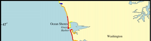
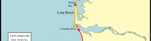
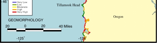
Figure 6.  Map of the geomorphology variable for southwestern Washington and northwestern Oregon. The open-ocean shoreline is composed predominantly of high-risk sandy pocket beaches interspersed with low-risk rocky headlands; to the north of Tillamook Head there is a long stretch of very high-risk sandy beach.


Click on map to zoom in

Figure 6. Map of the geomorphology variable for southwestern Washington and northwestern Oregon


Contents  Back to Top  Title Page

 Introduction  Risk
Variables
 Data
Ranking
 C.V.I.  Results  Discussion  Summary  References

[an error occurred while processing this directive]