
U.S. Geological Survey Open-File Report 00-410
Version 1.01
2001 (CD published)
2002 (Online version published)
Sea Floor Maps Showing Topography, Sun-Illuminated Topographic Imagery, and Backscatter Intensity of the Stellwagen Bank National Marine Sanctuary Region off Boston, Massachusetts
By Page C. Valentine, Tammie J. Middleton, and Sarah J. Fuller
Includes Encapsulated PostScript, PostScript, Arc export, Registered Tif, and Portable Document File formats of 3 individual maps.
INTRODUCTION
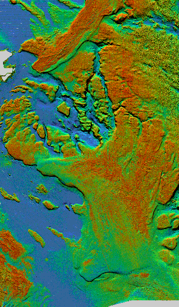
The three maps included in this report show the sea floor features of the Stellwagen Bank National Marine Sanctuary region at a scale of 1:60,000. They depict topography, sun-illuminated (shaded relief) topographic imagery, and combined imagery of sun-illuminated sea floor topography and backscatter intensity. Each of the three maps is presented in five formats (EPS, PS, TIF, Arc export, and PDF). Paper versions of these maps are in press (Valentine and others, 2001)(see "References" section).
The survey of approximately 1100 square nautical miles of sea floor was conducted on four cruises over a 2-year period from the fall of 1994 to the fall of 1996 using a multibeam echo sounder installed aboard the Canadian Hydrographic Service vessel Frederick G. Creed, a SWATH (Small Waterplane Area Twin Hull) ship that surveys at speeds up to 16 knots. See the "Methods" section for details of data acquisition and processing.
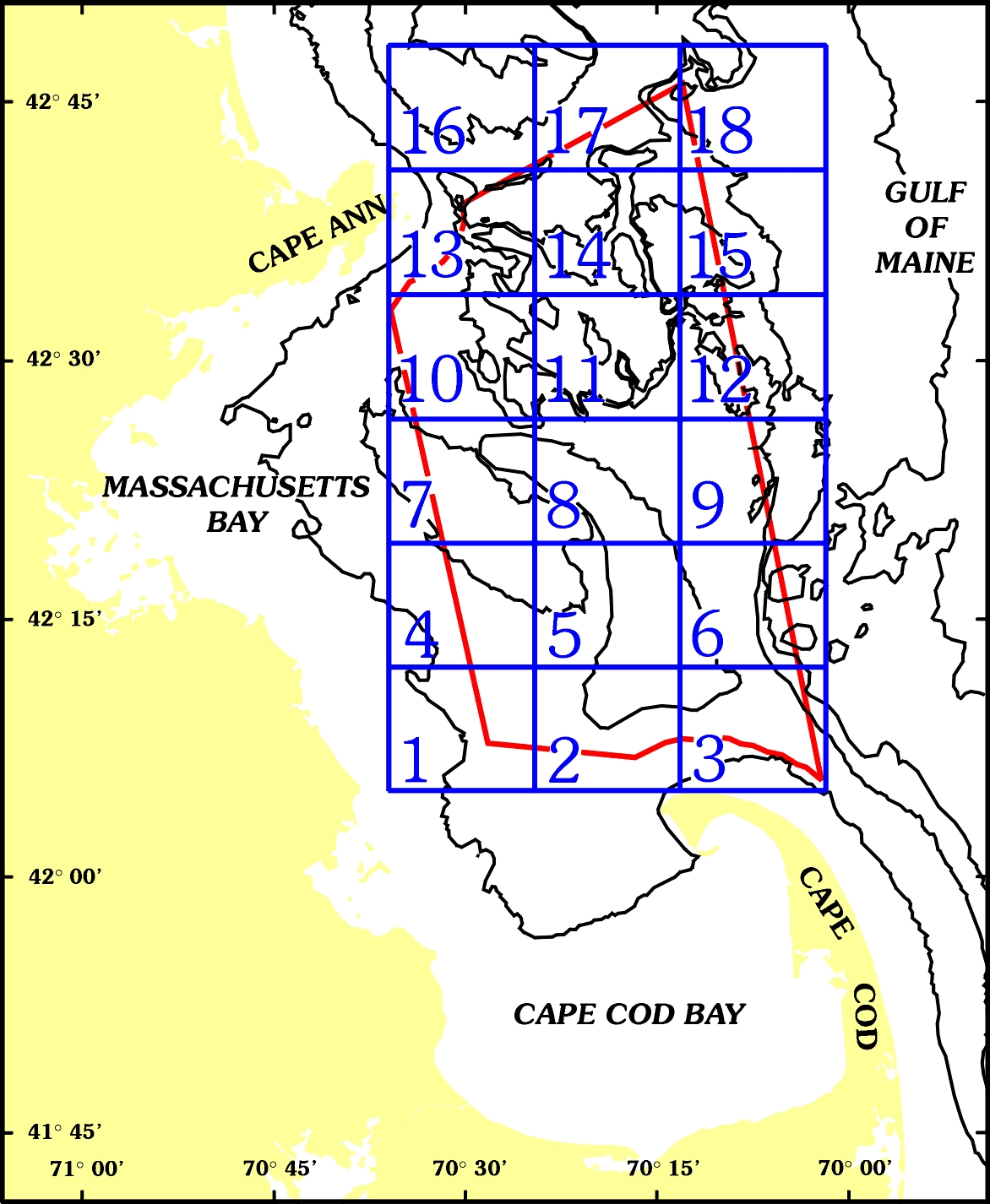
The project has published two map series of 18 quadrangles each (see location map, below) in which new sea floor topography and sun-illuminated imagery are presented at a scale of 1:25,000. See "References" section for a complete list of maps and CD-ROMs.
On the three maps presented here at a scale of 1:60,000, the locations of the corners of the 18 quadrangles are shown for reference as ticks labeled outside the map edges and as large crosses within the map area.
The great topographic detail of the seabed revealed by this survey warrants the naming here of many geographic features. Some features were named in consultation with local fishermen. The geographic names of the region are documented in the "Geographic Feature Names" section of this report.
The Stellwagen Bank National Marine Sanctuary Mapping Project is a cooperative effort of the U.S. Geological Survey and the National Oceanic and Atmospheric Administration, with support from the University of New Brunswick and the Canadian Hydrographic Service.
CONTENTS
Methods
Discussions Printed on Map Sheets
Geographic Feature Names
References to Related Map Series
PostScript Files
The PostScript files are included for printing and require a maximum page size of 26 inches by 36 inches (66 cm x 91.4 cm).
The Encapsulated PostScript (EPS) and PostScript files (PS) were generated from Adobe Illustrator version 9.0 and contain maps in a Mercator projection with the longitude of the central meridian at 70o 19'W and the latitude of true scale at 41o 39'N. The EPS files are included for the purposes of printing. The EPS files have been compressed with WinZip and require approximately 25 Mbytes of disc space when uncompressed.
PS Files (for printing)
EPS Files (for printing)
Arc Export Files
The Arc export files (e00) are coverages in a Geographic projection with Geodetic Reference System 1980 and North American Datum 1983. The attributes which accompany these coverages are depth and depression. The depth field contains positive values for each contour line. The depression field contains values representing topographic lows or depressions (identified by 1) and regular topographic contours (identified by 0).
PDF Files (for viewing, printing)
The Portable Document Files are included for viewing and printing using Adobe Acrobat Reader. Download a copy of Adobe Acrobat Reader version 5.0 for free.
TIF Files
The Tif and associated world file (tfw) can be incorporated into a GIS database for use with ArcView.
References for maps of each of the 18 Quadrangles (showing topography and sun-illuminated topographic imagery) can be seen by clicking on each quadrangle in the image below.
DISCLAIMER
This publication was prepared by
members of the US Geological Survey. Neither USGS or the United States
Government nor any agency thereof, nor any of their employees,
make any warranty, expressed or implied, or assumes any legal
liability or responsibility for the accuracy, completeness, or usefulness
of any information, apparatus, product, or process disclosed in this
report, or represents that its use would not infringe privately
owned rights. Reference therein to any specific commercial product,
process, or service by trade name, trademark, manufacturer, or otherwise
does not necessarily constitute or imply its endorsement, recommendation,
or favoring by the United States Government or any agency thereof.
Any views and opinions of authors expressed herein do not necessarily
state or reflect those of the United States Government
or any agency thereof.
CONTACTS
Paper copies of the maps and CD-ROMs can be obtained from the source listed below. See "References" section for map titles. This report is also available on CD-ROM from USGS Information Services. Because of the large file sizes, it might be better for some individuals to order the CD from Information Services.
USGS Information Services
Box 25286 Denver Federal Center
Denver, CO 80225-0046
(303) 202-4200