Open-File Report 01-448
Cruise Report; RV Moana Wave cruise M1-01-GM; the bathymetry and acoustic backscatter of the mid shelf to upper slope off Panama City, Florida, northeastern Gulf of Mexico; September 3, through October 12, 2001, Panama City, FL to Panama City, FLData Transformation Tides Bathymetry All bathymetric data were adjusted through Kongsberg Simrad
software for (1) transducer draft, (2) static roll, pitch and
gyro misalignments, (3) roll at reception, (4) refracted ray path,
and (5) beam steering at transducer interface. Post-logging transformations
included (1) transformation of navigation from antenna to transducer,
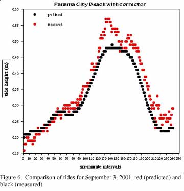
(2) correction for positioning to sonar time shifts, (3) tide,
and (4) any unaccounted-for static attitude misalignments.
Backscatter The Kongsberg Simrad EM1002 provides a backscatter-intensity time series for the bottom insonification period for each of the 111 individual beams. The corrections applied by the shipboard recording system are listed in Table 4. A set of required backscatter data transformations is performed by specialized software written by the Ocean Mapping Group at the University of New Brunswick. The transformations include conversion of each beam backscatter time series to a horizontal range equivalent, compiling the 111 beam traces together to produce one full slant-range-corrected trace, and removal of residual beam-pattern effects. Although the system software corrects for average beam pattern, there are ± 2 dB ripples in the average beam pattern that vary from transducer to transducer. Our processing approach to backscatter was to stack several thousand pings to view the angular variation of received backscatter intensity as a function of beam angle. Inherent in this function is both the transmit and receive sensitivities, as well as the mean angular response of the seafloor. We then invert this function to minimize the beam pattern and angular variations. Table 4. Corrections applied to each beam for backscatter.
Kongsberg Simrad uses a variable gain within 15° of vertical to reduce logged dynamic range at nadir and near-nadir. The sidescan data at this stage have had a Lambertian response backed out and the beam pattern has been corrected with respect to the vertical and all receive beams have been roll stabilized. Consequently, corrections have been made for variations in the beam-forming amplifiers but not variations in the stave sensitivities of the physical array. Additional transformations were required to produce calibrated backscatter measurements. These include (1) removal of Lambertian model, (2) true seafloor slope correction, (3) refracted ray-path correction, (4) residual beam-pattern correction, and (5) aspherical-spreading corrections. |
||||||||||||||||||||||||||||||||||||||
|
For more information, contact the PCMSC team.
Any use of trade, product, or firm names is for descriptive purposes only and does not imply endorsement by the U.S. Government. Suggested citation: Gardner, James V., Mayer, Larry A., Hughes Clarke, John E., Dartnell, Peter, Sulak, Kenneth J., 2001, Cruise Report; RV Moana Wave cruise M1-01-GM; the bathymetry and acoustic backscatter of the mid shelf to upper slope off Panama City, Florida, northeastern Gulf of Mexico; September 3, through October 12, 2001, Panama City, FL to Panama City, FL: U.S. Geological Survey Open-File Report 01-448, https://pubs.usgs.gov/of/2001/0448/. U.S. Department of the Interior U.S. Geological Survey |

![]() U.S. Department of the Interior |
U.S. Geological Survey
U.S. Department of the Interior |
U.S. Geological Survey
URL: http://pubsdata.usgs.gov/pubs/of/2001/0448/datatrans.html
Page Contact Information: GS Pubs Web Contact
Page Last Modified: Wednesday, 07-Dec-2016 18:58:12 EST
