Surficial Geology and Distribution of Post-Impoundment Sediment in Las Vegas Bay, Lake Mead
Discussion
Part II
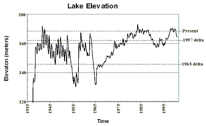
The lake's history is recorded in the sediment deposited on its floor. The completeness of this record is controlled by changes in lake's level, and the processes of deposition control the signature of the record. Although the lake is only 66 years old, it has undergone several changes in elevation during this time. The lake first reached its present elevation of approximately 360 m in 1942, but since then it has dropped by 25-37 m twice: 1954-1957 and 1964-1968 (Fig. 15). As recently as 1989-1997 the lake was 5-9 m lower than its present level. These changes have a dramatic effect on sedimentation in the shallow parts of the lake.
Click on each figure for larger image with caption.
Figure 15. Graph showing monthly elevation of Lake Mead since 1935. The dotted lines show three lake elevations significant to this study. Present refers to the time of the survey (June, 2000), and the other two lines show the elevation of the lake during two periods of delta formation.
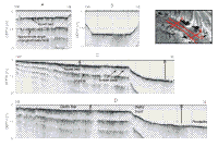
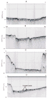
Deltas are directly tied to lake level. The two primary units seen in seismic profiles across deltas are the topset and foreset beds. These beds show most clearly in the delta at the mouth of Las Vegas Wash because it is the largest of the three deltas. The topset beds in these deltas are nearly flat, and consist of coarse material deposited in the floors of braided streams, and as such represent the
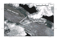
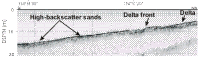
subaerial part of the delta. The aerial photograph in Figure 9A shows the braided stream crossing the subaerially exposed part of the delta, and the sidescan imagery suggests that it originally extended to the delta front (Fig. 9B and Fig. 10).Foreset beds form by sediment prograding at the delta front. These beds are deposited under water, make up the bulk of a delta and, as the delta progrades, are buried by the topset beds (Fig. 8C).
The finer grained prodelta deposits accumulate in deeper water beyond the toe of the delta. The transition from topset to foreset deposits is an approximate record of lake level, and this transition in the delta off Las Vegas Wash occurs in approximately 7-m water depth. This delta presumably built into the lake between 1989 and 1997 when the lake was 5-9 m lower than present (Fig. 15). This delta (called the 1997 delta) then was abandoned when the lake rose to its present level, and a new delta is now building on top of the 1997 delta. The present delta is only about 3 m thick, and the delta front marks the present shoreline, and thus could not be covered by this survey. The topset bed of the 1997 delta is buried by a blanket of sediment less than 1-m thick (Figs. 8A, C, D). This sediment blanket presumably is fine-grained prodelta material that is accumulating in front of the modern delta.
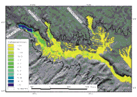
The tongues of thick sediment that were mapped in front of the 1997 deltas may be older deltas that perhaps formed between 1964-1968 when the lake was approximately 20 m lower than present. The tongues of thick sediment off the three deltas all occur in 20-25 m water depth. They are significantly thinner than the 1997 deltas, and the internal structure is poorly defined although the one off Government Wash does show foreset beds in it (Fig. 13D).
An alternative explanation is that these tongues are the same age as the 1997 delta and represent fans that form in front of the deltas by subaqueous density flows transporting sand from the delta front through small channels to these deeper water sites. The slope failures on the delta front off Las Vegas Wash indicate active erosion of the delta front and could be the source of sand for these fan deposits (Fig. 10). Beyond the delta front in Gypsum Wash is a narrow channel with a high-backscatter floor that leads from the delta front to the tongue of thick sediment beyond this delta (Fig. 12). Of these two explanations, the abandoned delta explanation seems the most reasonable. The fact that all three occur at nearly the same depth and foreset beds are seen in one of them argues for a deltaic origin.
The fine-grained prodelta sediment extends down the submerged valley in Las Vegas Bay for at least 7 km. This sediment only occurs in the valley floors, and appears to have smoothed the gradient of the original valley floor. For much of this area the sediment is less than 1 m thick, but in some patches it exceeds 2 m (Fig. 6). The thick areas tend to be depressions in the preimpoundment surface that are being filled. This sediment distribution pattern cannot be the result of sediment settling from suspension in the surface water. If sediment were raining from the water column, the resulting deposit would be more widely spread and would be covering the ridges as well as the valley floors. Instead, it appears that the fine-grained sediment is transported away from the mouths of the washes as dense turbid flows whose paths are controlled by the morphology of the lake floor. Gould (1951) first proposed this mechanism of transport for the fine-grained sediment for the deeper parts of Lake Mead where sediment derived from the Colorado River has been transported the full length of the lake. Although the scale is smaller, the same process appears to be active in Las Vegas Bay. Dispersal of sediment by density flows has transported more than half of the sediment delivered through the three washes great distances into Las Vegas Bay. Although the sandy deltaic deposits are most noticeable because of the dramatic shoaling of the lake floor, the mud is dispersed much further into the lake. This process of dispersal of the fine-grained component of the river load may have further implications to other environmental issues in the lake.
|