Holocene Evolution, OFR 01-076
Home | Intro | Geology | Methods | Animation | Data | GIS | Acknowledgements | References | AppendixA huge amount of sediment has been supplied to
the coast in the Pacific Northwest by the Columbia River during the Holocene.
One result of this sediment supply is that the coast of northern Oregon and
southern Washington distinguishes itself from many coastal environments around
the US generally because it has accreted rather than retreated during
historical time (Dolan and others, 1985). Sediment from the Columbia River is not limited to the beaches, but also blankets a large part of the shelf (Nittrouer, 1978; Wolf and others, 1997), and has filled estuaries along this coast (Peterson and Phipps, 1992; Gates, 1994). Recently, the coast has started to
show signs of change. Historically, some areas have been accreting, but now they are undergoing severe erosion. The causes of the transition from accretion to erosion are not understood, but have been attributed to anthropogenic activity both in the coastal zone and in the Columbia River drainage basin (Phipps, 1990;
Gelfenbaum and others, 1999; Peterson and others,
1999; Kaminsky and others, 1999).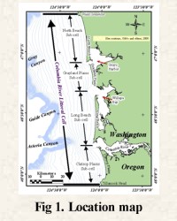
The U.S. Geological Survey and the Washington State Department of Ecology initiated a multidisciplinary cooperative study to gather information on the entire coastal system to address the causes for the recent change to increased erosion of this coast (Gelfenbaum and others, 1999; Kaminsky and others, 1999; Gelfenbaum and Kaminsky, 1999). The coastal system, known as the Columbia River littoral cell (CRLC), extends from Tillamook Head, OR to Point Grenville, WA. This area includes the barriers and beaches as well as the adjacent shelf and bays (Fig. 1). The full scope of the project has been summarized by Gelfenbaum and others (1999), Kaminsky and others (1999), Peterson and others (1999), and Ruggiero and others (1999). There are also reports summarizing annual project workshops (Gelfenbaum and Kaminsky, 1999; 2000). A description of the study and initial results can also be found on line at: URL: http://www.ecy.wa.gov/programs/sea/swce.
This report presents
the data and results of the component of the study that mapped the distribution
and thickness of Holocene aged sediment in the CLRC. The
results are presented in both paper form and digitally on the CD-ROM.
Goals of the study included mapping the lateral extent of sediment derived from the Columbia
River, the volume of sediment, how sediment is partitioned through different
parts of the system, and how this coastal system has evolved during the last
11,000 years. To achieve these goals, we have drawn on a variety of offshore and
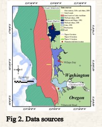
onshore data sets that were either collected specifically for this study or from the literature (Fig. 2). These data, which include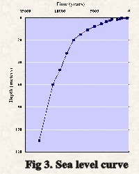 seismic-reflection data from the continental shelf, boreholes from the barriers,
dune ridge ages from the barriers, and borehole and seismic-reflection data from the
bays and lower Columbia River will be described in the Data
Sets
section
of the Geologic Discussion. The seismic-reflection data and
surfaces derived from the integration of the varied data sets were incorporated
into a GIS that is published on this CD-ROM (GIS section). The
mechanics of integrating these varied data types is described in the Methods
section, and Metadata accompanies the data presented on
this CD-ROM. The GIS is used to compute sediment volumes and to show how
sediment is partitioned throughout the littoral cell (Geologic Discussion).
A sea level curve for the Pacific Northwest (Fig. 3), sedimentation rates
derived from available cores (Herb, 2000), and beach ridge ages
(Reckendorf and
others, 2001) were used in concert with the GIS to show the evolution of this
coast from 11,000 years before present (yr BP) to the present (Animation).
seismic-reflection data from the continental shelf, boreholes from the barriers,
dune ridge ages from the barriers, and borehole and seismic-reflection data from the
bays and lower Columbia River will be described in the Data
Sets
section
of the Geologic Discussion. The seismic-reflection data and
surfaces derived from the integration of the varied data sets were incorporated
into a GIS that is published on this CD-ROM (GIS section). The
mechanics of integrating these varied data types is described in the Methods
section, and Metadata accompanies the data presented on
this CD-ROM. The GIS is used to compute sediment volumes and to show how
sediment is partitioned throughout the littoral cell (Geologic Discussion).
A sea level curve for the Pacific Northwest (Fig. 3), sedimentation rates
derived from available cores (Herb, 2000), and beach ridge ages
(Reckendorf and
others, 2001) were used in concert with the GIS to show the evolution of this
coast from 11,000 years before present (yr BP) to the present (Animation).
[an error occurred while processing this directive]