|
|
|
|
|
Early Geologic History
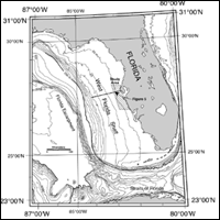
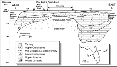
Carbonate Platform DevelopmentThe siliciclastic-dominated, west-central barrier island coast of peninsular Florida and its adjacent inner continental shelf lie at the center of a huge, ancient carbonate platform and form the proximal portion of the west Florida shelf/slope system. This platform's east-to-west lateral dimensions extend 500 km from the 200 m water depth shelf break off the east coast of Florida to the 1,500 m top of the west Florida escarpment, which drops precipitously nearly another 1,800 m into the deep Gulf of Mexico (Figure 4). With the Florida/Bahamas platform being approximately 900 km long, 1,000 km wide, and over 12 km thick (Sheridan et al., 1988), this platform represented an enormous shallow-water accumulating, carbonate sedimentary province (Figure 5). The Florida/Bahamas platform was part of an even larger Jurassic carbonate "gigaplatform" that extended contiguously over 6,000 km from the Gulf of Mexico to the Grand Banks and probably was one of the largest carbonate platform systems in earth's history (Poag, 1991). By the mid Cretaceous, the western portion of the Florida Platform drowned possibly as a result of environmental stress and rising sea level (Corso et al., 1989; Vogt, 1989; Buffler, 1991; summarized in Hine, 1997). The environmental stress may have resulted from world-wide oceanic anoxic events, which could have been imported onto carbonate-producing, shallow shelves during periods of high sea level (Arthur and Schlanger, 1979; Vogt, 1989). Because this combination of environmental stress and rising sea level , sediment production and accumulation rates could not keep pace with tectonic subsidence associated with a relatively young passive margin. So, formerly shallow, neritic environments passed through the photic zone creating the pelagic environment seen today. By the early Cenozoic, the Florida Platform had been transformed into a topographically asymmetric feature with the eastern portion elevated and the western portion sloping into deeper water. Here, the seafloor passed below the photic zone allowing carbonate accumulation rates to be greatly reduced compared to their shallow-water counterparts (Schlager, 1981; Mullins et al., 1987, 1988a,b). The western portion of the Florida Platform thus was transformed from a rim-type platform into a gently-sloping ramp, which terminated at the top of the eroding marginal escarpment. This 250 km wide ramp underlies the modern west Florida shelf-slope system and explains why the shelf system seaward of the entire west Florida coast has such a low gradient. There is a broad shelf-edge transition from approximately 100 to 200 m depth occurring over approximately 100 km between the shelf and the slope (Figure 6).
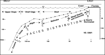
The west Florida shelf-slope system has been used extensively as a modern analog for non-rimmed, carbonate platforms, deep shelves, or ramps (Ahr, 1973; Ginsburg and James, 1974; Read, 1982; Hine and Mullins, 1983; Mullins et al., 1987; 1988a,b; Feary and James, 1998). Perhaps, Read's (1982) distally inclined ramp model is the best overall descriptor of the west Florida shelf/slope system. The Siliciclastic InvasionBy mid Cenozoic time (late Oligocene), the Suwannee Seaway and the Gulf Trough, two consecutive open seaways connecting the northern Gulf of Mexico to the Atlantic across northern Florida and Georgia, had been infilled (Chen, 1965; McKinney, 1984; Popenoe et al., 1987). This infilling probably occurred during sea-level lowstands when rivers draining off the southern Appalachian Mountains built deltas, which extended south and onlapped carbonates of the northern Florida Platform. This was the initial phase of Florida's siliciclastic "invasion," which continues today as quartz sand moves south along the beaches bordering peninsular Florida. The siliciclastic invasion is an important event in Florida's geologic history, because this process provided the State with the materials to create the high-quality beaches people enjoy today. Quartz sand transport onto the Florida platform was primarily via the dominant north-to-south longshore transport system. The surficial morphology of the peninsular Florida is dominated by these former siliciclastic shorelines (White, 1970). However, recent work (Warzeski at al, 1996; Cunningham et al, 1998; Guertin et al, 2000, Cunningham et al., 2001a,b) have shown that a river delta up to 120 m thick filled accommodation space within the south central Florida Platform during the late Miocene. Nevertheless, rivers from the southern Appalachian Mountains and the southern coastal plain drained into the northern Gulf and the Atlantic rather than down peninsular Florida. Because the eastern portion of the platform was relatively elevated and influenced by the frequent rise and fall of sea level, the quartz-rich sands were selectively sequestered to the east leaving the deeply submerged western portion of the platform to continue to accumulate carbonate sediments slowly. By virtue of numerous sea-level fluctuations and the net southerly transport of siliciclastic sediments, quartz sand was transported all the way to the extreme southern margin of the platform by Pliocene time and reached the slope extending into the southern Straits of Florida. However, toward the western portion of the platform, there was no effective mechanism of transporting siliciclastic sediments across this ramp into deeper water. As a result, the quartz-rich sediment on the eastern portion of peninsular Florida transitions into carbonate-rich sediment toward the west. The inner shelf off the west-central barrier-island system forms part of that quartz to mixed quartz carbonate transition. Furthermore, the present west Florida shelf can be subdivided into distinct N-S trending, carbonate facies belts (Figure 6; Ginsburg and James 1974). As previous investigators have pointed out, this east-to-west quartz-to-carbonate transition has been poorly defined (Ginsburg and James, 1974; Doyle and Sparks, 1980). As the results of several studies in this special issue show, the inner shelf is commonly dominated by NW-SE trending quartz-rich, sand ridges. These sand ridges extend beyond 20 km out onto the shelf, thus making it nearly impossible to precisely define a facies boundary or even a restricted transition zone between the quartz-dominated, mixed quartz/carbonate, and carbonate-dominated surficial sediment facies. |