|
|
|
|
|
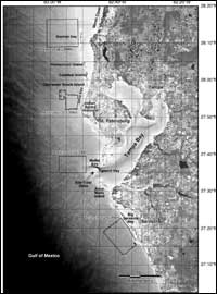
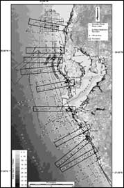
Field Strategy, Data Base, and ProductsThe 200 km length of the west-central Florida barrier-island coast presents an unusual degree of morphological complexity as compared to other barrier-island systems such as the famous North Carolina Outer Banks or the Texas coast, for example. As a result, our primary strategy was to concentrate our effort along the northern half of this barrier-island system from Anclote Key to the Venice headland, which are natural geologic boundaries and not arbitrary or political boundaries (Figure 2). This division was made for practical reasons such as limited logistics, time, and resources. Even within this 100 km natural subdivision, we further concentrated our efforts along nine onshore-to-offshore transects, each several kilometers wide for logistical reasons (Figure 3). Each transect represents a fundamentally different aspect of the coastline and inner shelf system with the sum of all nine transects representing nearly the full range of coastal morphologies, shelf provinces, sediment distributions, and stratigraphic variability. Therefore, the heart of our data products are nine USGS Open File Reports (Locker et al., 2001, b-j) each presenting a wide variety of geologic framework data along a single transect. They can be obtained at the following URL address: http://coastal.er.usgs.gov/wfla/. Each of these reports represent a cross-shore transect extending from the mainland, across the lagoon, barrier island, and terminating out on the inner-shelf setting. Each reveals surficial and subsurface features using side-scan sonar imagery, high-resolution seismic reflection profiles, surface grab samples, vibracores, aerial photos, and bathymetry. In addition to these nine USGS Open File Reports are four side-scan sonar mosaics representing different shelf provinces (Donahue et al., 2000; Harrison et al., 2000; Locker et al., 2000; Twichell and Paskevich, 1999; and Twichell et al., 2000), a digitally generated bathymetric map (Gelfenbaum and Guy, 1999), a map illustrating the distribution of beach engineering structures (Gelfenbaum et al., 1999; Figure 1), and finally a map presenting the distribution of different geologic data types collected (Locker et al., 2001a; Figure 3). A full listing of these USGS Open File Reports appears in Appendix 1. In addition, the West-Central Florida Coastal Studies Project funded two physical process-oriented studies, the results of which are not shown in these USGS Open File Reports, but constitute significant contributions to our understanding of west-central Florida coastal and shelf system. An extensive, regional shelf circulation study has been published in Yang et al. (1999), Yang and Weisberg (1999) and other associated published works referenced and summarized in the West-Central Florida Shelf Hydrography and Circulation section. Additionally, a site-specific study of transverse bar movement in the mouth of Tampa Bay is summarized in the Nearshore/Coastal Processes section. Graduate and undergraduate students were involved in this overall effort and a large data set is collectively presented in the theses completed by these students (see Appendix 2). Published abstracts representing papers or posters presented at meetings are also cited in Appendix 2.
Finally, as of this writing (December, 2001) the various investigators have submitted 20 manuscripts to be published in a special volume of Marine Geology. A list of titles is presented in Appendix 3. Please contact:
Dr. G.R. Brooks for a status report on the progress of that volume. The USGS Open File Reports, the student theses, published abstracts, and the existing and planned publications represent the total work effort by our group on this project. It also collectively represents one of the most comprehensive regional, geologic framework studies on any coastal/inner shelf system. |
||||||||||||||||||||||||||||||||||||||||||||||||||||||||||||||||||||||||||||||||||||||||||||||||||||||||