| |  |  | | Lake Pontchartrain Atlas: | | | | | | | | | | | | | | | | | | | | | | | | | Basin Geology |  | | | | | | | | | | | | | | | | | | | |  | | | | | | | | | | |  | Basin Geology - Geologic Resources Contributor: Beall, Kindinger Sand and gravel is Louisiana's second most valuable nonfuel resource. In 1999, Louisiana produced over $210 million of sand and gravel. All the state's sand and gravel come from Quaternary deposits, most of which lie in the southeastern portion of the state, including Pleistocene river and coast-parallel terrace deposits and Holocene river alluvium. Crushed stone and sand and gravel are the two main sources of natural aggregate. Both are used in most residential, commercial, and industrial buildings, and in public works projects such as roads and highways, bridges, railroads, dams, airports, water and sewer systems, and tunnels. Together, crushed stone and sand and gravel make up approximately half the volume of mined minerals in the United States. Crushed stone and sand and gravel are widely used commodities that are important elements in many national industries. Sand and gravel (or sand alone) can be used for industrial purposes such as foundry operations, in glass manufacturing, as an abrasive, and in filtration beds of water-treatment facilities. Crushed stone and sand and gravel, however, are most commonly used as aggregate in the construction industry. As an example, an average 1,500-square-foot home requires approximately 114 tons of aggregate. If you add each home's proportional share of new streets, schools, churches, municipal projects, and shopping centers, the total aggregate use per home increases to approximately 328 tons (http://water.roman.net/usmining.html). In Pontchartrain Basin crushed stone is not heavily represented, there are currently 3 crushed stone producers in the lower Mississippi delta (Fig. 49) with most of the product imported from other regions. Sand and gravel producers have decreased from a high of 170 mines (Fig. 48) to a current 143 mines located in 5 watersheds within the basin. Text Contributor: Jack Kindinger 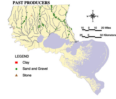 | | Figure 48: Location of past aggregate mine producers in the LPB. | | Table 5: Number of Current Aggregate Mines by Watershed | | Watershed | Clay | Sand and Gravel | Stone | | Amite | 1 | 61 | - | | Bogue Chitto | - | 21 | - | | Lower Pearl | 1 | 32 | - | | Mississippi Delta | 1 | 2 | 3 | | Tangipahoa | - | 27 | - | |
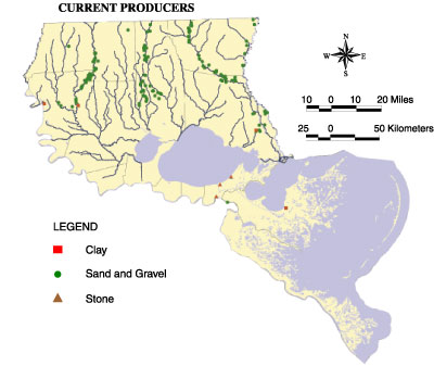 | | Figure 49: Location of current aggregate mine producers in the LPB. | | Table 6: Number of Past Aggregate Mines by Watershed | | Watershed | Clay | Sand and Gravel | Stone | | Amite | 1 | 53 | - | | Bogue Chitto | - | 48 | - | | Lower Pearl | - | 39 | - | | Mississippi Delta | - | - | - | | Tangipahoa | - | 30 | - | |
« Previous | Next » |
