USGS Home - www.usgs.gov
Coastal and Marine Geology Program
Coastal & Marine Geology Program > Center for Coastal & Regional Marine Studies > Environmental Atlas of Lake Pontchartrain

Environmental Atlas of the Lake Pontchartrain Basin

Lake Pontchartrain Atlas Home
Lake Pontchartrain Atlas:
Preface
Table of Contents
Introduction
Environmental Overview
Environmental Status & Trends
Restoration
Physical Environments
Basin Geology You are at the Basin Geology section of the Environmental Atlas of Lake Pontchartrain
Biological Resources
Environmental Issues
Bibliography
Resources
Contributors
Acronyms
Contact:
Jack Kindinger
Basin Geology: Geology | Quarternary Framework | Geomorphology | Bathymetry | Geologic Resources

Basin Geology - Geologic Resources

Contributors: Beall

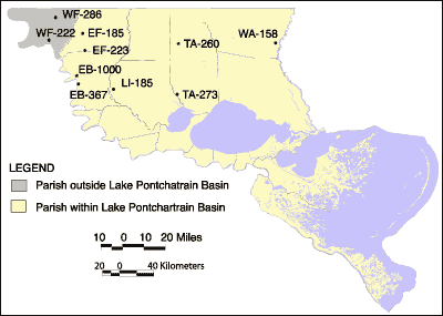
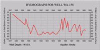
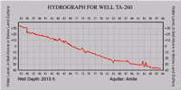
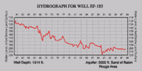
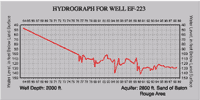
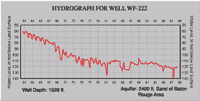
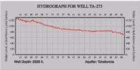
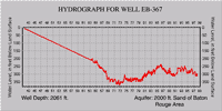
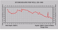
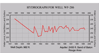
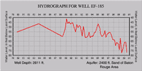
Geology of Jasper Equivalent Aquifers

The Jasper Equivalent aquifer system is composed of the Miocene aged aquifers of the Baton Rouge area and St. Tammany, Tangipahoa, and Washington Parishes. These Miocene sediments outcrop in southwestern Mississippi. The sedimentary sequences that make up the aquifer system are subdivided into several aquifer units separated by confining beds. Northward within southeast Louisiana, fewer units are recognized because some younger units pinch out updip and some clay layers present to the south disappear. Where clay layers are discontinuous or disappear, aquifer units coalesce. The aquifers consist of fine to coarse sand and gravel, with grain size increasing and sorting decreasing with depth.

Hydrogeology

The deposits that constitute the individual aquifers are not readily differentiated at the surface and act as one hydraulic system that can be subdivided into several hydrologic zones in the subsurface. A zone or ridge of saline water occurs within the Miocene sediments beneath the Mississippi River alluvial valley. Recharge occurs primarily by the direct infiltration of rainfall in interstream, upland outcrop areas, and by the movement of water between aquifers. The hydraulic conductivity varies between 10-200 feet/day.

The maximum depths of occurrence of freshwater in the Jasper Equivalent range from 152.4 to 975.4 m (500 to 3,200 ft) below sea level. The range of thickness of the fresh water interval in the Jasper Equivalent is 487.7 to 716.3 m (1,600 to 2,350 ft). The depths of the Jasper Equivalent wells that were monitored in conjunction with the Baseline Monitoring Project range from 292.6 to 822. 9 m (960 to 2,700 ft).

Text source: Baseline Monitoring Project, 2000, EPA Fiscal Years '98-'00 (State Fiscal Years '98-'00, July 1997 to June 2000), First Triennial Summary Report for the Environmental Evaluation Division of the Louisiana Department of Environmental Quality, http://www.deq.state.la.us/evaluation/aeps/triennial2000/index.htm

Map showing well sites.
Figure 46: Well location map for hydrographs showing in Figure 47. Aquifers mentioned are of same horizon as Jasper formation. Source: U.S. Geological Survey, Ground Water Resources of Louisiana.

Well WA-158 Hydrograph for well TA-260
Well WA-158 Well TA-260
Hydrograph for well EF-185 Hydrograph for well EF-223
Well EF-185 Well EF-223
Hydrograph for well WF-222 Hydrograph for well TA-273
Well WF-222 Well TA-273
Hydrograph for well EB-367 Hydrograph for well EB-1000
Well EB-367 Well EB-1000
Hydrograph for well WF-286 Hydrograph for well EF-185
Well WF-286 Well EF-185
Figure 48: Hydrographs of individual wells on an annual time scale. Also shown are well depths and aquifer name. Click on an individual hydrograph to see a larger version.

« Previous | Next »


Coastal & Marine Geology Program > Center for Coastal & Regional Marine Studies > Environmental Atlas of Lake Pontchartrain

FirstGov.govemail Feedback [an error occurred while processing this directive]