USGS Home - www.usgs.gov
Coastal and Marine Geology Program
Coastal & Marine Geology Program > Center for Coastal & Regional Marine Studies > Environmental Atlas of Lake Pontchartrain

Environmental Atlas of the Lake Pontchartrain Basin

Lake Pontchartrain Atlas Home
Lake Pontchartrain Atlas:
Preface
Table of Contents
Introduction
Environmental Overview
Environmental Status & Trends
Restoration
Physical Environments
Basin Geology You are at the Basin Geology section of the Environmental Atlas of Lake Pontchartrain
Biological Resources
Environmental Issues
Bibliography
Resources
Contributors
Acronyms
Contact:
Jack Kindinger
Basin Geology: Geology | Quarternary Framework | Geomorphology | Bathymetry | Geologic Resources

Basin Geology - Geologic Resources

Contributors: Beall

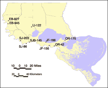
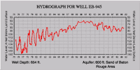
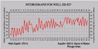
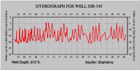
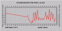
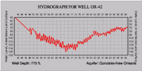
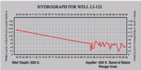
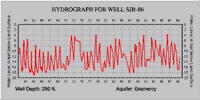
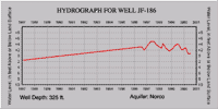
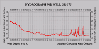
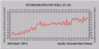
Geology of Chicot Equivalent Aquifer System

The Chicot Equivalent aquifer system is composed of the Pleistocene aged aquifers of the New Orleans area, the Baton Rouge area, and St. Tammany, Tangipahoa, and Washington Parishes. The aquifers are in Pleistocene aged alluvial and terrace deposits. The sedimentary sequences that make up the aquifer system are subdivided into several aquifer units separated by confining beds. Northward within southeast Louisiana, fewer units are recognized because some younger units pinch out updip and some clay layers present to the south disappear. Where clay layers are discontinuous or disappear, aquifer units coalesce. The aquifers are moderately well, to well sorted, and consist of fine sand near the top, grading to coarse sand and gravel in lower parts and are generally confined by silt and clay layers.

Hydrogeology

The deposits that constitute the individual aquifers are not readily differentiated at the surface and act as one hydraulic system that can be subdivided into several hydrologic zones in the subsurface. The Mississippi River Valley is entrenched into the Pleistocene strata in the western part of the system, resulting in water movement between the river, the shallow sands, and the Pleistocene aquifers. Recharge occurs primarily by the direct infiltration of rainfall in interstream, upland outcrop areas, by the movement of water between aquifers, and between the aquifers and the Mississippi River. The hydraulic conductivity varies between 10-200 feet/day.

The maximum depths of occurrence of freshwater in the Chicot Equivalent range from 160.6 m (350 ft) above sea level, to 335.3 m (1,100 ft) below sea level. The range of thickness of the fresh water interval in the Chicot Equivalent is 15.2 to 335.3 m (50 to 1,100 ft). The depths of the Chicot Equivalent wells that were monitored in conjunction with the Baseline Monitoring Project range from 26.8 to 246 m (88 to 807 ft).

Text source: Baseline Monitoring Project, 2000, EPA Fiscal Years '98-'00 (State Fiscal Years '98-'00, July 1997 to June 2000), First Triennial Summary Report for the Environmental Evaluation Division of the Louisiana Department of Environmental Quality, http://www.deq.state.la.us/evaluation/aeps/triennial2000/index.htm

Map showing well sites.
Figure 42: Well location maps for hydrographs shown in Figure 43. Aquifers mentioned are of same horizon as Chicot formation. Source: U.S. Geological Survey, Ground Water Resources of Louisiana.

Hydrograph for well EB-945 Hydrograph for well EB-827
Well EB-945 Well EB-827
Hydrograph for well SJB-145 Hydrograph for well SJ-203
Well SJB-145 Well SJ-203
Hydrograph for well OR-42 Hydrograph for well LI-122
Well OR-42 Well LI-122
Hydrograph for well SJB-86 Hydrograph for well JF-186
Well SJB-86 Well JF-186
Hydrograph for well OR-175 Hydrograph for well JF-156
Well OR-175 Well JF-156
Figure 43: Hydrographs of individual wells on an annual time scale. Also shown are well depths and aquifer names. Click on the individual images for a larger version.

« Previous | Next »


Coastal & Marine Geology Program > Center for Coastal & Regional Marine Studies > Environmental Atlas of Lake Pontchartrain

FirstGov.govemail Feedback [an error occurred while processing this directive]